Capo di Vado Lighthouse
 Capo di Vado Lighthouse | |
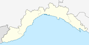 Capo di Vado Location of Capo Vado Lighthouse in Liguria  Capo di Vado Capo di Vado (Italy) | |
| Location |
Vado Ligure Liguria Italy |
|---|---|
| Coordinates | 44°15′29″N 8°27′09″E / 44.258083°N 8.452600°ECoordinates: 44°15′29″N 8°27′09″E / 44.258083°N 8.452600°E |
| Year first constructed | 1883 |
| Automated | yes |
| Foundation | concrete base |
| Construction | masonry tower |
| Tower shape | octagonal prism tower with balcony and lantern |
| Markings / pattern | white tower, grey metallic lantern dome |
| Height | 34 metres (112 ft) |
| Focal height | 43 metres (141 ft) |
| Current lens | Type OF |
| Light source | mains power |
| Range |
main: 14 nautical miles (26 km; 16 mi) reserve: 7 nautical miles (13 km; 8.1 mi) |
| Characteristic | Fl (4) W 15s. |
| Admiralty number | E1172 |
| NGA number | 7396 |
| ARLHS number | ITA-017 |
| Italy number | 1514 E.F. |
| Managing agent | Marina Militare[1][2] |
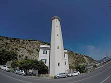
Capo di Vado Lighthouse (Italian: Faro di Capo di Vado) is an active lighthouse located on the prominent Capo di Vado, 1.5 kilometres (0.93 mi) south of Vado Ligure, Liguria on the Ligurian Sea.
Description
The lighthouse was built in 1883 and consists of a white masonry octagonal prism tower, 34 feet (10 m) high, with balcony and lantern attached to the seaward side of a 3-storey white keeper's house The lantern is painted in white, the dome in grey metallic, and is positioned at 43 metres (141 ft) above sea level and emits four white flashes in a 15 seconds period visible up to a distance of 14 nautical miles (26 km; 16 mi). The lighthouse is completely automated and operated by the Marina Militare with the identification code number 1514 E.F.[2]
See also
References
- ↑ "Lighthouses of Italy: Liguria". The Lighthouse Directory. Retrieved September 23, 2018.
External links
| Wikimedia Commons has media related to Capo di Vado Lighthouse. |
This article is issued from
Wikipedia.
The text is licensed under Creative Commons - Attribution - Sharealike.
Additional terms may apply for the media files.