Monte Cristi Province
| Monte Cristi | |||
| Province | |||
 Coastline of Monte Cristi | |||
|
|||
| Country | |||
|---|---|---|---|
| Capital | San Fernando de Monte Cristi | ||
| - elevation | 16 m (52 ft) | ||
| - coordinates | 19°51′0″N 71°39′0″W / 19.85000°N 71.65000°WCoordinates: 19°51′0″N 71°39′0″W / 19.85000°N 71.65000°W | ||
| Area | 1,924.35 km2 (743 sq mi) | ||
| Population | 150,833 (2014) [1] | ||
| Density | 78/km2 (202/sq mi) | ||
| Province since | 1879 | ||
| Subdivisions | 6 municipalities 4 municipal districts | ||
| Congresspersons | 1 Senator 2 Deputies | ||
| Timezone | EST (UTC-4) | ||
| Area code | 1-809 1-829 1-849 | ||
| ISO 3166-2 | DO-15 | ||
| Postal Code | 62000 | ||
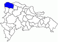 Location of the Monte Cristi Province | |||

Monte Cristi (Spanish pronunciation: [ˈmonte ˈkɾisti]) is a province in the northwest of the Dominican Republic. The capital city is San Fernando de Monte Cristi (usually simply Monte Cristi). The spelling Montecristi is also seen.
Municipalities and municipal districts
The province as of June 20, 2006 is divided into the following municipalities (municipios) and municipal districts (distrito municipal, D.M.) in them:[2]
- Castañuela
- Palo Verde (D.M.)
- Guayubín
- Cana Chapetón (D.M.)
- Hatillo Palma (D.M.)
- Villa Elisa (D.M.)
- Las Matas de Santa Cruz
- Pepillo Salcedo
- San Fernando de Monte Cristi
- Villa Vásquez
The following is a sortable table of the municipalities and municipal districts with population figures as of the 2012 census. Urban population are those living in the seats (cabeceras literally heads) of municipalities or of municipal districts. Rural population are those living in the districts (secciones: sections) and neighborhoods (parajes: stops) outside of them.[3]
| Name | Total population | Urban population | Rural population |
|---|---|---|---|
| Castañuela | 14,878 | 4,005 | 10,873 |
| Guayubín | 32,586 | 5,899 | 26,687 |
| Las Matas de Santa Cruz | 18,756 | 9,515 | 9,241 |
| Pepillo Salcedo | 11,588 | 4,983 | 6,605 |
| San Fernando de Monte Cristi | 42,657 | 26,868 | 15,789 |
| Villa Vásquez | 15,245 | 12,191 | 3,054 |
| Monte Cristi province | 135,710 | 63,461 | 72,249 |
For comparison with the municipalities and municipal districts of other provinces see the list of municipalities and municipal districts of the Dominican Republic.
References
- ↑ Consejo Nacional de Población y Familia. "Estamaciones y Proyecciones de la Población Dominicana por Regiones, Provincias, Municipios y Distritos Municipales, 2014" (PDF) (in Spanish). Retrieved 2014-02-02.
- ↑ Oficina Nacional de Estadistica, Departamento de Cartografia, Division de Limites y Linderos. "Listado de Codigos de Provincias, Municipio y Distritos Municipales, Actualizada a Junio 20 del 2006" (in Spanish). Archived from the original on 2007-03-14. Retrieved 2007-01-24.
- ↑ Consejo Nacional de Población y Familia. "Censos y Proyecciones de la Población Dominicana por Regiones, Provincias, Municipios y Distritos Municipales, 2012" (PDF) (in Spanish). Retrieved 2012-01-11.
External links
- (in Spanish) Oficina Nacional de Estadística, Statistics Portal of the Dominican Republic
- (in Spanish) Oficina Nacional de Estadística, Maps with administrative division of the provinces of the Dominican Republic, downloadable in PDF format
- (in English) / Airport Information in Montecristi / FlyDominicanRepublic.com