Rural Municipality of Montcalm
Montcalm (French: Municipalité rurale de Montcalm) is a rural municipality in the province of Manitoba in Western Canada. It is located in the southern part of the province, along its border with the state of North Dakota in the United States. The 2016 Census reported a population of 1,260 persons, a decrease from the 1,309 reported in the 2011 Census. The town of Emerson lies at the southeast corner of the municipality, although it is an administratively separate entity. The Roseau River Anishinabe First Nation lies between Montcalm R.M. and the Rural Municipality of Franklin to the east.
Geography
According to Statistics Canada, the rural municipality has an area of 469.41 km² (181.24 sq mi). The administratively separate town of Emerson lies at its southeast corner, and also borders the Rural Municipality of Franklin, as well as both North Dakota and Minnesota in the United States. Most of the St. Joseph Wind Farm lies within the RM.
Communities
- Letellier
- St. Jean Baptiste
- St. Joseph
- Ste. Elizabeth
Adjacent rural municipalities and counties
- Rural Municipality of Rhineland - (west)
- Rural Municipality of Morris - (north)
- Rural Municipality of De Salaberry - (northeast)
- Rural Municipality of Franklin - (east)
- Emerson (town) - (southeast)
- Pembina County, North Dakota - (south)
Places adjacent to Rural Municipality of Montcalm | |
|---|---|
External links
| Cities | 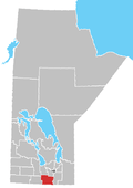 | ||
|---|---|---|---|
| Towns |
| ||
| Rural municipalities |
| ||
| Unincorporated communities | |||
Coordinates: 49°10′39″N 97°19′29″W / 49.17750°N 97.32472°W