Montague Township, New Jersey
| Montague Township, New Jersey | |
|---|---|
| Township | |
| Township of Montague | |
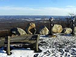 High Point State Park | |
| Nickname(s): "The Top of New Jersey" | |
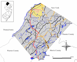 Map of Montague Township in Sussex County. Inset: Location of Sussex County highlighted in the State of New Jersey. | |
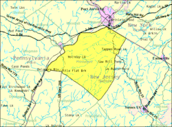 Census Bureau map of Montague Township, New Jersey. | |
| Coordinates: 41°16′51″N 74°43′50″W / 41.280864°N 74.730427°WCoordinates: 41°16′51″N 74°43′50″W / 41.280864°N 74.730427°W[1][2] | |
| Country |
|
| State |
|
| County | Sussex |
| Royal patent | March 26, 1759 |
| Incorporated | February 21, 1798 |
| Government[3] | |
| • Type | Township |
| • Body | Township Committee |
| • Mayor | Gene L. Crawford (R, term ends December 31, 2017)[4][5] |
| • Municipal clerk | Eileen DeFabiis[6] |
| Area[1] | |
| • Total | 45.380 sq mi (117.533 km2) |
| • Land | 43.997 sq mi (113.951 km2) |
| • Water | 1.383 sq mi (3.582 km2) 3.05% |
| Area rank |
40th of 566 in state 3rd of 24 in county[1] |
| Elevation[7] | 1,066 ft (325 m) |
| Population (2010 Census)[8][9][10] | |
| • Total | 3,847 |
| • Estimate (2016)[11] | 3,718 |
| • Rank |
418th of 566 in state 13th of 24 in county[12] |
| • Density | 87.4/sq mi (33.7/km2) |
| • Density rank |
547th of 566 in state 22nd of 24 in county[12] |
| Time zone | UTC-5 (Eastern (EST)) |
| • Summer (DST) | UTC-4 (Eastern (EDT)) |
| ZIP code | 07827[13] |
| Area code(s) | 973 Exchanges: 293, 948[14] |
| FIPS code | 3403747430[1][15][16] |
| GNIS feature ID | 0882256[1][17] |
| Website |
www |
Montague Township is a township in Sussex County, New Jersey, United States, in the New York City Metropolitan Area. As of the 2010 United States Census, the township's population was 3,847,[8][9][10] reflecting an increase of 435 (+12.7%) from the 3,412 counted in the 2000 Census, which had in turn increased by 580 (+20.5%) from the 2,832 counted in the 1990 Census.[18] High Point, within Montague Township, is the highest elevation within New Jersey at an altitude of 1,803 feet (550 m) above sea level. Montague is also the northernmost municipality in the state of New Jersey.
Most of the area of Montague Township is public lands, primarily High Point State Park, Stokes State Forest, and Delaware Water Gap National Recreation Area. Montague is known for its scenery and wildlife, and summer sports in the area include hiking, biking, camping (both public and private campgrounds are available), and fishing.
The derivation of the township's name is uncertain, though suggestions include that it was named after the George Montagu, 4th Duke of Manchester, as suggested by King George II, who approved the royal patent on March 26, 1759;[19] for Lady Mary Wortley Montagu, an author who was popular at the time; or for solicitor John Montague.[20] Montague was incorporated on February 21, 1798, by an act of the New Jersey Legislature as one of New Jersey's initial group of 104 townships.[21]
Before Montague Township was granted its own post office in the 1980s, residents had all of their mail delivered through the 12771 ZIP code for Port Jervis, New York, leading to situations where residents had New Jersey driver's licenses with a New York State mailing address.[22]
Geography
According to the United States Census Bureau, the township had a total area of 45.380 square miles (117.533 km2), including 43.997 square miles (113.951 km2) of land and 1.383 square miles (3.582 km2) of water (3.05%).[1][2]
Unincorporated communities, localities and place names located partially or completely within the township include Brick House, Duttonville, Four Corners, High Point, High Point Park, Lake Marcia, Mashipacong Island, Mashipacong Pond, Millville and Minisink Island.[23]
The Tri-States Monument, also known as the Tri-State Rock, marks only the northwest end of the New Jersey and New York land boundary but not the north end of the New Jersey and Pennsylvania boundary as it purports to do.[24] The true north end of the New Jersey and New York boundary, as well as the true north end of the New Jersey and Pennsylvania boundary and thus the true tri-state point is located 47.25 feet (14.40 m) to the west, in the middle of the Delaware River in diving distance of the eastbound Interstate 84 overpass. The marker is a small granite block with inscribed lines marking the supposed boundaries of the three states and a bronze National Geodetic Survey marker at the purported but mistaken triple point. The current Tri-State Monument was erected in 1884 as a replacement for the original monument erected in 1774, which was important in resolving the New York - New Jersey Line War.[25]


Climate
This climatic region is typified by large seasonal temperature differences, with warm to hot (and often humid) summers and cold (sometimes severely cold) winters. According to the Köppen Climate Classification system, Montague Township has a humid continental climate, abbreviated "Dfb" on climate maps.[26]
Demographics
| Historical population | |||
|---|---|---|---|
| Census | Pop. | %± | |
| 1810 | 661 | — | |
| 1820 | 964 | 45.8% | |
| 1830 | 990 | 2.7% | |
| 1840 | 1,025 | 3.5% | |
| 1850 | 1,010 | −1.5% | |
| 1860 | 983 | −2.7% | |
| 1870 | 932 | −5.2% | |
| 1880 | 1,022 | 9.7% | |
| 1890 | 797 | −22.0% | |
| 1900 | 710 | −10.9% | |
| 1910 | 621 | −12.5% | |
| 1920 | 534 | −14.0% | |
| 1930 | 581 | 8.8% | |
| 1940 | 621 | 6.9% | |
| 1950 | 602 | −3.1% | |
| 1960 | 879 | 46.0% | |
| 1970 | 1,131 | 28.7% | |
| 1980 | 2,066 | 82.7% | |
| 1990 | 2,832 | 37.1% | |
| 2000 | 3,412 | 20.5% | |
| 2010 | 3,847 | 12.7% | |
| Est. 2016 | 3,718 | [11][27] | −3.4% |
| Population sources: 1810-1920[28] 1840[29] 1850-1870[30] 1850[31] 1870[32] 1880-1890[33] 1890-1910[34] 1910-1930[35] 1930-1990[36] 2000[37][38] 2010[8][9][10] | |||
Census 2010
As of the 2010 United States Census, there were 3,847 people, 1,535 households, and 1,045 families residing in the township. The population density was 87.4 per square mile (33.7/km2). There were 1,802 housing units at an average density of 41.0 per square mile (15.8/km2). The racial makeup of the township was 92.33% (3,552) White, 2.63% (101) Black or African American, 0.23% (9) Native American, 1.01% (39) Asian, 0.00% (0) Pacific Islander, 1.46% (56) from other races, and 2.34% (90) from two or more races. Hispanic or Latino of any race were 6.39% (246) of the population.[8]
There were 1,535 households out of which 26.8% had children under the age of 18 living with them, 53.0% were married couples living together, 9.4% had a female householder with no husband present, and 31.9% were non-families. 25.9% of all households were made up of individuals, and 8.1% had someone living alone who was 65 years of age or older. The average household size was 2.50 and the average family size was 3.03.[8]
In the township, the population was spread out with 22.8% under the age of 18, 6.9% from 18 to 24, 24.5% from 25 to 44, 31.9% from 45 to 64, and 13.9% who were 65 years of age or older. The median age was 42.3 years. For every 100 females there were 100.8 males. For every 100 females ages 18 and older there were 100.2 males.[8]
The Census Bureau's 2006-2010 American Community Survey showed that (in 2010 inflation-adjusted dollars) median household income was $64,526 (with a margin of error of +/- $9,763) and the median family income was $68,542 (+/- $13,778). Males had a median income of $44,105 (+/- $14,473) versus $33,996 (+/- $5,832) for females. The per capita income for the borough was $26,411 (+/- $2,961). About 7.3% of families and 8.2% of the population were below the poverty line, including 12.6% of those under age 18 and 6.4% of those age 65 or over.[39]
Census 2000
As of the 2000 United States Census[15] there were 3,412 people, 1,286 households, and 910 families residing in the township. The population density was 77.5 people per square mile (29.9/km²). There were 1,588 housing units at an average density of 36.1 per square mile (13.9/km²). The racial makeup of the township was 95.25% White, 1.79% African American, 0.18% Native American, 0.67% Asian, 1.08% from other races, and 1.03% from two or more races. Hispanic or Latino of any race were 3.28% of the population.[37][38]
There were 1,286 households out of which 34.9% had children under the age of 18 living with them, 57.4% were married couples living together, 8.2% had a female householder with no husband present, and 29.2% were non-families. 23.2% of all households were made up of individuals and 7.5% had someone living alone who was 65 years of age or older. The average household size was 2.65 and the average family size was 3.14.[37][38]
In the township the population was spread out with 27.2% under the age of 18, 6.4% from 18 to 24, 31.2% from 25 to 44, 24.1% from 45 to 64, and 11.1% who were 65 years of age or older. The median age was 37 years. For every 100 females, there were 107.0 males. For every 100 females age 18 and over, there were 102.5 males.[37][38]
The median income for a household in the township was $45,368, and the median income for a family was $50,833. Males had a median income of $39,569 versus $25,221 for females. The per capita income for the township was $20,676. About 8.5% of families and 12.0% of the population were below the poverty line, including 18.1% of those under age 18 and 6.3% of those age 65 or over.[37][38]
Government
Local government
Montague Township is governed under the Township form of government. The five-member Township Committee is elected directly by the voters at-large in partisan elections to serve three-year terms of office on a staggered basis, with either one or two seats coming up for election each year as part of the November general election in a three-year cycle.[3][40] At an annual reorganization meeting, the Township Committee selects one of its members to serve as Mayor and another as Deputy Mayor.
As of 2017, members of the Montague Township Committee are Mayor Gene L. Crawford (R, term on committee ends December 31, 2018; term as mayor ends 2017), Deputy Mayor Paul M. Brislin (R, term on committee ends 2018; term as deputy mayor ends 2017), Glenn Barbagallo (R, 2017), Richard E. Innella (R, 2019) and George E. Zitone.[4][41][42][43][44]
Federal, state and county representation
Montague Township is located in the 5th Congressional District[45] and is part of New Jersey's 24th state legislative district.[9][46][47]
New Jersey's Fifth Congressional District is represented by Josh Gottheimer (D, Wyckoff).[48] New Jersey is represented in the United States Senate by Democrats Cory Booker (Newark, term ends 2021)[49] and Bob Menendez (Paramus, 2019).[50][51]
For the 2018–2019 session (Senate, General Assembly), the 24th Legislative District of the New Jersey Legislature is represented in the State Senate by Steve Oroho (R, Franklin) and in the General Assembly by Parker Space (R, Wantage Township) and Harold J. Wirths (R, Hardyston Township).[52][53] The Governor of New Jersey is Phil Murphy (D, Middletown Township).[54] The Lieutenant Governor of New Jersey is Sheila Oliver (D, East Orange).[55]
Sussex County is governed by a Board of Chosen Freeholders whose five members are elected at-large in partisan elections on a staggered basis, with either one or two seats coming up for election each year. At an annual reorganization meeting held in the beginning of January, the board selects a Freeholder Director and Deputy Director from among its members, with day-to-day supervision of the operation of the county delegated to a County Administrator.[56] As of 2014, Sussex County's Freeholders are Freeholder Director Richard Vohden (R, Green Township, 2016),[57] Deputy Director Dennis J. Mudrick (R, Sparta Township, 2015),[58] Phillip R. Crabb (R, Franklin, 2014),[59] George Graham (R, Stanhope, 2016)[60] and Gail Phoebus (R, Andover Township, 2015).[61][56] Graham was chosen in April 2013 to fill the seat vacated by Parker Space, who had been chosen to fill a vacancy in the New Jersey General Assembly.[62] Constitutional officers elected on a countywide basis are County Clerk Jeff Parrott (R, 2016),[63] Sheriff Michael F. Strada (R, 2016)[64] and Surrogate Gary R. Chiusano (R, filling the vacancy after the resignation of Nancy Fitzgibbons).[65][62] The County Administrator is John Eskilson.[66][67]
Politics
As of March 23, 2011, there were a total of 2,448 registered voters in Montague Township, of which 328 (13.4% vs. 16.5% countywide) were registered as Democrats, 1,247 (50.9% vs. 39.3%) were registered as Republicans and 870 (35.5% vs. 44.1%) were registered as Unaffiliated. There were 3 voters registered to other parties.[68] Among the township's 2010 Census population, 63.6% (vs. 65.8% in Sussex County) were registered to vote, including 82.4% of those ages 18 and over (vs. 86.5% countywide).[68][69]
In the 2012 presidential election, Republican Mitt Romney received 1,001 votes (63.6% vs. 59.4% countywide), ahead of Democrat Barack Obama with 530 votes (33.7% vs. 38.2%) and other candidates with 39 votes (2.5% vs. 2.1%), among the 1,575 ballots cast by the township's 2,426 registered voters, for a turnout of 64.9% (vs. 68.3% in Sussex County).[70] In the 2008 presidential election, Republican John McCain received 1,150 votes (63.9% vs. 59.2% countywide), ahead of Democrat Barack Obama with 592 votes (32.9% vs. 38.7%) and other candidates with 35 votes (1.9% vs. 1.5%), among the 1,799 ballots cast by the township's 2,421 registered voters, for a turnout of 74.3% (vs. 76.9% in Sussex County).[71] In the 2004 presidential election, Republican George W. Bush received 1,072 votes (68.5% vs. 63.9% countywide), ahead of Democrat John Kerry with 466 votes (29.8% vs. 34.4%) and other candidates with 20 votes (1.3% vs. 1.3%), among the 1,564 ballots cast by the township's 2,072 registered voters, for a turnout of 75.5% (vs. 77.7% in the whole county).[72]
In the 2013 gubernatorial election, Republican Chris Christie received 74.6% of the vote (750 cast), ahead of Democrat Barbara Buono with 21.8% (219 votes), and other candidates with 3.7% (37 votes), among the 1,015 ballots cast by the township's 2,446 registered voters (9 ballots were spoiled), for a turnout of 41.5%.[73][74] In the 2009 gubernatorial election, Republican Chris Christie received 832 votes (68.6% vs. 63.3% countywide), ahead of Democrat Jon Corzine with 243 votes (20.0% vs. 25.7%), Independent Chris Daggett with 103 votes (8.5% vs. 9.1%) and other candidates with 22 votes (1.8% vs. 1.3%), among the 1,212 ballots cast by the township's 2,402 registered voters, yielding a 50.5% turnout (vs. 52.3% in the county).[75]
Education
Students in public school for kindergarten through eighth grade attend the Montague Township School District.[76] As of the 2014-15 school year, the district and its one school had an enrollment of 349 students and 28.9 classroom teachers (on an FTE basis), for a student–teacher ratio of 12.1:1.[77]
Public school students in seventh through twelfth grades cross state lines to attend middle school and (had crossed to attend) high school in nearby Port Jervis, New York or may enroll at Sussex County Technical School, which accepts students on a selective basis, and to the middle school charter program in Sparta Township. Starting in September 2014, Montague Township's high school students began attending High Point Regional High School, in a shift from Port Jervis that will take four years to complete.[78] High Point also serves students from Branchville Borough, Frankford Township, Lafayette Township, Sussex Borough and Wantage Township (where the school is located).[79][80] As of the 2014-15 school year, High Point High School had an enrollment of 1,002 students and 94.3 classroom teachers (on an FTE basis), for a student–teacher ratio of 10.6:1.[81]
Transportation
As of May 2010, the township had a total of 55.97 miles (90.07 km) of roadways, of which 25.50 miles (41.04 km) were maintained by the municipality, 23.85 miles (38.38 km) by Sussex County and 6.13 miles (9.87 km) by the New Jersey Department of Transportation and 0.49 miles (0.79 km) by the Delaware River Joint Toll Bridge Commission.[82]
One U.S., state, and county route each traverses the township. U.S. Route 206 passes through in the western part and crosses the Delaware River at the Milford-Montague Toll Bridge. Route 23 passes through the eastern part and serves as the entrance road to High Point State Park and ends at the New York border just south of I-84. County Route 521 passes through the northwest and ends at the New York state boundary.
The closest limited access road is Interstate 84 (which used to be part of the New York State Thruway until October 2010) and is immediately over the state line in Deer Park, New York.
In the northernmost section of the township along Route 23, there are several gasoline stations, most likely because gas is significantly less expensive in New Jersey than in Matamoras, Pennsylvania or Port Jervis, New York.
The township does not have a traffic light.
Notable people
People who were born in, residents of, or otherwise closely associated with Montague Township include:
- Ed Banach (born 1960), athlete who won a gold medal in Freestyle Wrestling in the 198-pound-weight (heavyweight) class at the 1984 Summer Olympics in Los Angeles.[83]
- Lou Banach (born 1960), athlete who won a gold medal in Freestyle Wrestling in the 220-pound-weight (heavyweight) class at the 1984 Summer Olympics in Los Angeles.[83]
- John Westbrook Hornbeck (1804–1848), Whig Party member of the United States House of Representatives from Pennsylvania from 1847-1848.[84]
- Daniel Myers Van Auken (1826–1908) was a Democratic member of the U.S. House of Representatives from Pennsylvania from 1867 to 1871.[85]
- Kinuyo Yamashita, video game music composer and sound producer best known for her soundtrack for Konami's Castlevania.[86]
Wineries
References
- 1 2 3 4 5 6 2010 Census Gazetteer Files: New Jersey County Subdivisions, United States Census Bureau. Accessed May 21, 2015.
- 1 2 US Gazetteer files: 2010, 2000, and 1990, United States Census Bureau. Accessed September 4, 2014.
- 1 2 2012 New Jersey Legislative District Data Book, Rutgers University Edward J. Bloustein School of Planning and Public Policy, March 2013, p. 110.
- 1 2 Mayor & Township Committee, Montague Township. Accessed May 14, 2017.
- ↑ 2017 New Jersey Mayors Directory, New Jersey Department of Community Affairs. Accessed May 30, 2017. As of date accessed, George E. Zitone is listed incorrectly as mayor.
- ↑ Town Clerk, Montague Township. Accessed August 2, 2016.
- ↑ U.S. Geological Survey Geographic Names Information System: Township of Montague, Geographic Names Information System. Accessed March 8, 2013.
- 1 2 3 4 5 6 DP-1 - Profile of General Population and Housing Characteristics: 2010 for Montague township, Sussex County, New Jersey, United States Census Bureau. Accessed February 24, 2013.
- 1 2 3 4 Municipalities Grouped by 2011-2020 Legislative Districts, New Jersey Department of State, p. 11. Accessed January 6, 2013.
- 1 2 3 Profile of General Demographic Characteristics: 2010 for Montague township Archived 2016-03-11 at the Wayback Machine., New Jersey Department of Labor and Workforce Development. Accessed February 24, 2013.
- 1 2 PEPANNRES - Annual Estimates of the Resident Population: April 1, 2010 to July 1, 2016 - 2016 Population Estimates for New Jersey municipalities, United States Census Bureau. Accessed June 16, 2017.
- 1 2 GCT-PH1 Population, Housing Units, Area, and Density: 2010 - State -- County Subdivision from the 2010 Census Summary File 1 for New Jersey, United States Census Bureau. Accessed February 24, 2013.
- ↑ Look Up a ZIP Code for Montague, NJ, United States Postal Service. Accessed February 24, 2013.
- ↑ Area Code Lookup - NPA NXX for Montague, NJ, Area-Codes.com. Accessed October 5, 2014.
- 1 2 American FactFinder, United States Census Bureau. Accessed September 4, 2014.
- ↑ A Cure for the Common Codes: New Jersey, Missouri Census Data Center. Accessed October 29, 2012.
- ↑ US Board on Geographic Names, United States Geological Survey. Accessed September 4, 2014.
- ↑ Table 7. Population for the Counties and Municipalities in New Jersey: 1990, 2000 and 2010 Archived 2013-05-20 at the Wayback Machine., New Jersey Department of Labor and Workforce Development, February 2011. Accessed February 24, 2013.
- ↑ Hutchinson, Viola L. The Origin of New Jersey Place Names, New Jersey Public Library Commission, May 1945. Accessed September 7, 2015.
- ↑ History of Montague Archived 2015-06-25 at the Wayback Machine., Montague Association for the Restoration of Community History. Accessed May 19, 2013.
- ↑ Snyder, John P. The Story of New Jersey's Civil Boundaries: 1606-1968, Bureau of Geology and Topography; Trenton, New Jersey; 1969. p. 231. Accessed October 29, 2012.
- ↑ Hanley, Robert. "New Jersey Journal", The New York Times, May 11, 1980. Accessed August 2, 2016.
- ↑ Locality Search, State of New Jersey. Accessed May 21, 2015.
- ↑ Vermeule, C. Clarkson (1888). "Physical Description of New Jersey" (pdf). Final Report of the State Geologist. Vol. I. Topography. Magnetism. Climate. Trenton, New Jersey: Geological Survey of New Jersey. pp. 66–7.
- ↑ DeSanto, John. "845LIFE: Stone markers tell where three states meet", Times Herald-Record, November 8, 2015. Accessed June 18, 2017. "Well, you could drive on over to the Tri-States Monument in Port Jervis and stand in three states at the same time.... While the monument itself - where New York, New Jersey and Pennsylvania come together - is above water most of the time, it can sometimes be below water level when the Delaware River runs high, like in the spring.... While you are standing directly on the New York/New Jersey border, you are not technically standing in Pennsylvania. For that, you'd have to swim west into the Delaware exactly 47.25 feet and tread water."
- ↑ Climate Summary for Montague Township, New Jersey
- ↑ Census Estimates for New Jersey April 1, 2010 to July 1, 2016, United States Census Bureau. Accessed June 16, 2017.
- ↑ Compendium of censuses 1726-1905: together with the tabulated returns of 1905, New Jersey Department of State, 1906. Accessed May 19, 2013.
- ↑ Bowen, Francis. American Almanac and Repository of Useful Knowledge for the Year 1843, p. 231, David H. Williams, 1842. Accessed May 19, 2013.
- ↑ Raum, John O. The History of New Jersey: From Its Earliest Settlement to the Present Time, Volume 1, p. 271, J. E. Potter and company, 1877. Accessed February 24, 2013. "Montague is the most northern township, bordering on New York and Pennsylvania. It contained in 1850, 1,010 inhabitants; in 1860. 983; and in 1870, 932."
- ↑ Debow, James Dunwoody Brownson. The Seventh Census of the United States: 1850, p. 141. R. Armstrong, 1853. Accessed February 24, 2013.
- ↑ Staff. A compendium of the ninth census, 1870, p. 260. United States Census Bureau, 1872. Accessed February 24, 2013.
- ↑ Porter, Robert Percival. Preliminary Results as Contained in the Eleventh Census Bulletins: Volume III - 51 to 75, p. 97. United States Census Bureau, 1890. Accessed February 24, 2013.
- ↑ Thirteenth Census of the United States, 1910: Population by Counties and Minor Civil Divisions, 1910, 1900, 1890, United States Census Bureau, p. 338. Accessed August 30, 2012.
- ↑ Fifteenth Census of the United States : 1930 - Population Volume I, United States Census Bureau, p. 719. Accessed February 24, 2013.
- ↑ Table 6. New Jersey Resident Population by Municipality: 1930 - 1990 Archived 2015-05-10 at the Wayback Machine., New Jersey Department of Labor and Workforce Development. Accessed August 9, 2016.
- 1 2 3 4 5 Census 2000 Profiles of Demographic / Social / Economic / Housing Characteristics for Montague township, Sussex County, New Jersey, United States Census Bureau. Accessed February 24, 2013.
- 1 2 3 4 5 DP-1: Profile of General Demographic Characteristics: 2000 - Census 2000 Summary File 1 (SF 1) 100-Percent Data for Montague township, Sussex County, New Jersey, United States Census Bureau. Accessed February 24, 2013.
- ↑ DP03: Selected Economic Characteristics from the 2006-2010 American Community Survey 5-Year Estimates for Montague township, Sussex County, New Jersey, United States Census Bureau. Accessed February 24, 2013.
- ↑ "Forms of Municipal Government in New Jersey", p. 7. Rutgers University Center for Government Studies. Accessed June 3, 2015.
- ↑ 2017 Municipal User Friendly Budget, Montague Township. Accessed May 14, 2017.
- ↑ Sussex County, New Jersey General Election November 8, 2016, Official Results Summary Report, Sussex County, New Jersey, dated November 10, 2016. Accessed January 30, 2017.
- ↑ Sussex County General Election November 3, 2015 Summary Report Official Results, Sussex County, New Jersey Clerk, updated November 6, 2015. Accessed August 1, 2016.
- ↑ Sussex County General Election November 4, 2014 Summary Report Official Results, Sussex County, New Jersey Clerk, updated November 10, 2014. Accessed August 1, 2016.
- ↑ Plan Components Report, New Jersey Redistricting Commission, December 23, 2011. Accessed January 6, 2013.
- ↑ 2017 New Jersey Citizen's Guide to Government Archived 2017-04-07 at the Wayback Machine., p. 61, New Jersey League of Women Voters. Accessed May 30, 2017.
- ↑ Districts by Number for 2011-2020, New Jersey Legislature. Accessed January 6, 2013.
- ↑ Directory of Representatives: New Jersey, United States House of Representatives. Accessed January 5, 2012.
- ↑ About Cory Booker, United States Senate. Accessed January 26, 2015. "He now owns a home and lives in Newark's Central Ward community."
- ↑ Biography of Bob Menendez, United States Senate, January 26, 2015. "He currently lives in Paramus and has two children, Alicia and Robert."
- ↑ Senators of the 114th Congress from New Jersey. United States Senate. Accessed January 26, 2015. "Booker, Cory A. - (D - NJ) Class II; Menendez, Robert - (D - NJ) Class I"
- ↑ Legislative Roster 2018-2019 Session, New Jersey Legislature. Accessed January 22, 2018.
- ↑ District 24 Legislators, New Jersey Legislature. Accessed January 22, 2018.
- ↑ Governor Phil Murphy, State of New Jersey. Accessed January 16, 2018.
- ↑ Lieutenant Governor Oliver, State of New Jersey. Accessed January 16, 2018. "Assemblywoman Oliver has resided in the City of East Orange for over 40 years."
- 1 2 Sussex County Board of Chosen Freeholders, Sussex County, New Jersey. Accessed July 28, 2014.
- ↑ Richard A. Vohden, Sussex County, New Jersey. Accessed July 28, 2014.
- ↑ Dennis J. Mudrick, Sussex County, New Jersey. Accessed July 28, 2014.
- ↑ Phillip R. Crabb, Sussex County, New Jersey. Accessed July 28, 2014.
- ↑ George Graham, Sussex County, New Jersey. Accessed July 28, 2014.
- ↑ Gail Phoebus, Sussex County, New Jersey. Accessed July 28, 2014.
- 1 2 Miller, Jennifer Jean. "George Graham Chosen as Freeholder at Sussex County Republican Convention", TheAlternativePress.com, April 13, 2013. Accessed April 25, 2013. "Graham will fill the freeholder seat that New Jersey Assemblyman Parker Space left to take his new position. Space recently took the seat, which formerly belonged to Gary Chiusano, who in turn, was appointed to the spot of Sussex County Surrogate, following the retirement of Surrogate Nancy Fitzgibbons."
- ↑ Home Page, Sussex County Clerk's Office. Accessed July 28, 2014.
- ↑ Sheriff's Office, Sussex County, New Jersey. Accessed July 28, 2014.
- ↑ Home Page, Sussex County Surrogate. Accessed July 28, 2014.
- ↑ County Administrator, Sussex County, New Jersey. Accessed July 28, 2014.
- ↑ Sussex County Official Directory 2014, Sussex County, New Jersey. Accessed July 28, 2014.
- 1 2 Voter Registration Summary - Sussex, New Jersey Department of State Division of Elections, March 23, 2011. Accessed February 24, 2013.
- ↑ GCT-P7: Selected Age Groups: 2010 - State -- County Subdivision; 2010 Census Summary File 1 for New Jersey, United States Census Bureau. Accessed February 24, 2013.
- ↑ General Election November 6, 2012: District Report - Group Detail Archived June 6, 2013, at the Wayback Machine., Sussex County, New Jersey Clerk, run date November 30, 2012. Accessed February 24, 2013.
- ↑ 2008 Presidential General Election Results: Sussex County, New Jersey Department of State Division of Elections, December 23, 2008. Accessed February 24, 2013.
- ↑ 2004 Presidential Election: Sussex County, New Jersey Department of State Division of Elections, December 13, 2004. Accessed February 24, 2013.
- ↑ "Governor - Sussex County" (PDF). New Jersey Department of Elections. January 29, 2014. Retrieved December 24, 2014.
- ↑ "Number of Registered Voters and Ballots Cast - November 5, 2013 - General Election Results - Sussex County" (PDF). New Jersey Department of Elections. January 29, 2014. Retrieved December 24, 2014.
- ↑ 2009 Governor: Sussex County, New Jersey Department of State Division of Elections, December 31, 2009. Accessed February 24, 2013.
- ↑ Montagie Township School District 2016 Report Card Narrative, New Jersey Department of Education. Accessed May 14, 2017. "Montague Township is located in the Delaware Highlands Region of New Jersey. High Point State Park and Stokes State Forest provide the scenery to this rural Sussex County community. Montague Township School District is a Pre-K through grade 8 school in Sussex County. Montague students attend High Point Regional High School for grades 9 through 12. Sussex County Technical School and parent choice school are also options for students."
- ↑ District information for Montague Township School District, National Center for Education Statistics. Accessed December 7, 2016.
- ↑ Montague Township School District 2015 District Narrative, New Jersey School Report Card. Accessed June 7, 2016. "In September 2014, the district began to transition incoming ninth grade students from the Port Jervis City School District in Port Jervis New York into High Point Regional School District in Jew Jersey. The transition of high school students into High Point Regional School District will be complete by 2017."
- ↑ High Point Regional High School 2015 Report Card Narrative, New Jersey Department of Education. Accessed June 8, 2016. "High Point Regional High School is a comprehensive high school serving the diversified needs of the three surrounding K through 8 school districts of Lafayette, Frankford, Montague, and Sussex-Wantage."
- ↑ 2015-16 School Profile, High Point Regional High School. Accessed June 8, 2016. "Located 63 miles northwest of Manhattan in bucolic Sussex, County NJ, High Point serves students from six municipalities: Branchville, Lafayette, Frankford, Montague, Sussex, and Wantage."
- ↑ School data for High Point Regional High School, National Center for Education Statistics. Accessed December 12, 2016.
- ↑ Sussex County Mileage by Municipality and Jurisdiction, New Jersey Department of Transportation, May 2010. Accessed July 18, 2014.
- 1 2 Staff. "Branch Twins Grapple With Their Problems", The New York Times, June 22, 1984. Accessed May 3, 2015. "Within a year, Ed and Lou were given up by one couple, but taken in by another one, which also had taken another brother, Steve, who was 5. Ed and Lou were 4. The couple, Alan and Stephanie Tooley, had been married eight years and had given up on having children. They lived in a ranch house on an acre in Montague, N.J."
- ↑ HORNBECK, John Westbrook, (1804 - 1848), Biographical Directory of the United States Congress. Accessed May 3, 2015.
- ↑ VAN AUKEN, Daniel Myers, (1826 - 1908), Biographical Directory of the United States Congress. Accessed May 3, 2015.
- ↑ Kinuyo Yamashita, MobyGames. Accessed May 3, 2015.
External links
- Montague Township website
- Montague Township School District
- Montague Township School District's 2015–16 School Report Card from the New Jersey Department of Education
- School Data for the Montague Township School District, National Center for Education Statistics
Municipalities and communities of Sussex County, New Jersey, United States | ||
|---|---|---|
| Boroughs |  | |
| Town | ||
| Townships | ||
| CDPs | ||
| Other unincorporated communities | ||
Places adjacent to Montague Township, New Jersey | ||||||||||
|---|---|---|---|---|---|---|---|---|---|---|
| ||||||||||