Andover Township, New Jersey
| Andover Township, New Jersey | |
|---|---|
| Township | |
| Township of Andover | |
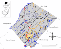 Map of Andover Township in Sussex County. Inset: Location of Sussex County highlighted in the State of New Jersey. | |
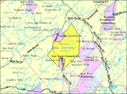 Census Bureau map of Andover Township, New Jersey. | |
| Coordinates: 41°01′48″N 74°43′38″W / 41.030051°N 74.727124°WCoordinates: 41°01′48″N 74°43′38″W / 41.030051°N 74.727124°W[1][2] | |
| Country |
|
| State |
|
| County | Sussex |
| Incorporated | April 11, 1864 |
| Named for | Andover, Hampshire, England |
| Government[3] | |
| • Type | Township |
| • Body | Township Committee |
| • Mayor | Thomas D. Walsh Jr. (R, term ends December 31, 2018)[4][5] |
| • Administrator / Municipal clerk | Diana Francisco[6] |
| Area[1] | |
| • Total | 20.687 sq mi (53.580 km2) |
| • Land | 19.956 sq mi (51.686 km2) |
| • Water | 0.731 sq mi (1.894 km2) 3.53% |
| Area rank |
137th of 566 in state 12th of 24 in county[1] |
| Elevation[7] | 600 ft (200 m) |
| Population (2010 Census)[8][9][10] | |
| • Total | 6,319 |
| • Estimate (2016)[11] | 6,006 |
| • Rank |
334th of 566 in state 8th of 24 in county[12] |
| • Density | 316.6/sq mi (122.2/km2) |
| • Density rank |
474th of 566 in state 13th of 24 in county[12] |
| Time zone | UTC-5 (Eastern (EST)) |
| • Summer (DST) | UTC-4 (Eastern (EDT)) |
| ZIP Code | 07821[13][14] |
| Area code(s) | 973 Exchange: 786[15] |
| FIPS code | 3403701360[1][16][17] |
| GNIS feature ID | 0882266[1][18] |
| Website |
www |
Andover Township is a township in Sussex County, New Jersey, United States. As of the 2010 United States Census, the township's population was 6,319,[8][9][10] reflecting an increase of 286 (+4.7%) from the 6,033 counted in the 2000 Census, which had in turn increased by 595 (+10.9%) from the 5,438 counted in the 1990 Census.[19]
Andover was incorporated as a township by an act of the New Jersey Legislature on April 11, 1864, from portions of Newton Township, which was split up on that date and dissolved. Portions of the township were taken to form Fredon Township (February 24, 1904) and Andover borough (March 25, 1904). Portions of the township were ceded to Newton town in both 1869 and 1927.[20]
The township was suggestively named after the existing village of Andover, whose name origin is not certain,[21] though sources indicate that the name comes from Andover, Hampshire, England.[22] In the years before World War II, Andover Township was home to Camp Nordland, a retreat and gathering place covering 204 acres (83 ha) owned and operated by the German American Bund, an American Nazi organization devoted to promoting a favorable view of Nazi Germany. Camp Nordland was shut down by the federal government after Germany declared war on the United States and sold at auction in 1944.[23] The property eventually was acquired by Andover Township and is now called Hillside Park with a recreational hall and sports fields.
Geography
According to the United States Census Bureau, the township had a total area of 20.687 square miles (53.580 km2), including 19.956 square miles (51.686 km2) of land and 0.731 square miles (1.894 km2) of water (3.53%).[1][2]
Unincorporated communities, localities and place names located partially or completely within the township include Brighton, County Road Camp, Davis Pond, Drakes Pond, Garders Lake, Iliffs Lake, Lake Aeroflex, Lake Iliff, Lake Lenape, Long Pond, Mulford, New Waywayanda Lake, Pinkneyville, Redings Pond, Springdale, Stickle Pond, Sussex Mills, Whitehall and Whites Pond.[24]
Demographics
| Historical population | |||
|---|---|---|---|
| Census | Pop. | %± | |
| 1870 | 1,126 | — | |
| 1880 | 1,150 | 2.1% | |
| 1890 | 1,126 | −2.1% | |
| 1900 | 987 | −12.3% | |
| 1910 | 521 | * | −47.2% |
| 1920 | 473 | −9.2% | |
| 1930 | 496 | 4.9% | |
| 1940 | 591 | 19.2% | |
| 1950 | 1,052 | 78.0% | |
| 1960 | 2,177 | 106.9% | |
| 1970 | 3,040 | 39.6% | |
| 1980 | 4,506 | 48.2% | |
| 1990 | 5,438 | 20.7% | |
| 2000 | 6,033 | 10.9% | |
| 2010 | 6,319 | 4.7% | |
| Est. 2016 | 6,006 | [11][25] | −5.0% |
| Population sources: 1870-1920[26] 1870[27][28] 1880-1890[29] 1890-1910[30] 1910-1930[31] 1930-1990[32] 2000[33][34] 2010[8][9][10] * = Lost territory in previous decade.[20] | |||
Census 2010
As of the 2010 United States Census, there were 6,319 people, 2,070 households, and 1,590 families residing in the township. The population density was 316.6 per square mile (122.2/km2). There were 2,181 housing units at an average density of 109.3 per square mile (42.2/km2). The racial makeup of the township was 91.64% (5,791) White, 3.37% (213) Black or African American, 0.17% (11) Native American, 2.60% (164) Asian, 0.00% (0) Pacific Islander, 0.73% (46) from other races, and 1.49% (94) from two or more races. Hispanic or Latino of any race were 5.14% (325) of the population.[8]
There were 2,070 households out of which 34.9% had children under the age of 18 living with them, 64.8% were married couples living together, 7.9% had a female householder with no husband present, and 23.2% were non-families. 19.2% of all households were made up of individuals, and 6.0% had someone living alone who was 65 years of age or older. The average household size was 2.70 and the average family size was 3.10.[8]
In the township, the population was spread out with 22.1% under the age of 18, 5.5% from 18 to 24, 22.2% from 25 to 44, 34.2% from 45 to 64, and 16.0% who were 65 years of age or older. The median age was 45.1 years. For every 100 females there were 99.8 males. For every 100 females ages 18 and older there were 95.6 males.[8]
The Census Bureau's 2006-2010 American Community Survey showed that (in 2010 inflation-adjusted dollars) median household income was $95,313 (with a margin of error of +/- $10,064) and the median family income was $105,554 (+/- $13,995). Males had a median income of $72,066 (+/- $10,198) versus $47,750 (+/- $8,020) for females. The per capita income for the borough was $38,284 (+/- $4,082). About 2.3% of families and 2.9% of the population were below the poverty line, including 1.0% of those under age 18 and 0.0% of those age 65 or over.[35]
Census 2000
As of the 2000 United States Census[16] there were 6,033 people, 1,889 households, and 1,499 families residing in the township. The population density was 298.9 people per square mile (115.4/km2). There were 1,968 housing units at an average density of 97.5 per square mile (37.7/km2). The racial makeup of the township was 94.45% White, 1.86% African American, 0.08% Native American, 2.30% Asian, 0.03% Pacific Islander, 0.60% from other races, and 0.68% from two or more races. Hispanic or Latino of any race were 2.25% of the population.[33][34]
There were 1,889 households out of which 39.8% had children under the age of 18 living with them, 67.9% were married couples living together, 8.0% had a female householder with no husband present, and 20.6% were non-families. 16.1% of all households were made up of individuals and 5.0% had someone living alone who was 65 years of age or older. The average household size was 2.80 and the average family size was 3.16.[33][34]
In the township the population was spread out with 25.0% under the age of 18, 4.6% from 18 to 24, 28.9% from 25 to 44, 25.7% from 45 to 64, and 15.7% who were 65 years of age or older. The median age was 40 years. For every 100 females, there were 91.9 males. For every 100 females age 18 and over, there were 87.2 males.[33][34]
The median income for a household in the township was $75,748, and the median income for a family was $78,439. Males had a median income of $57,098 versus $36,268 for females. The per capita income for the township was $29,180. About 1.3% of families and 3.5% of the population were below the poverty line, including 1.9% of those under age 18 and 5.3% of those age 65 or over.[33][34]
Government
Local government
Andover Township is governed under the Township form of government by a five-member Township Committee. The five-member Township Committee is elected directly by the voters at-large in partisan elections to serve three-year terms of office on a staggered basis, with either one or two seats coming up for election each year as part of the November general election in a three-year cycle.[3][36] At an annual reorganization held in January, the council selects a mayor and a deputy mayor from among its members.
As of 2016, members of the Andover Township Committee are Mayor Dolores Blackburn (R, term as mayor ends December 31, 2017; term on township committee ends 2016), Deputy Mayor John Burke (R, term on committee ends 2017; term as deputy mayor ends 2016), Ellsworth E. Bensley Jr. (R, 2018), Janis L. McGovern (R, 2018) and Thomas D. Walsh Jr. (R, 2016).[4][37][38][39][40]
Federal, state and county representation
Andover Township is located in the 5th Congressional district[41] and is part of New Jersey's 24th state legislative district.[9][42][43]
New Jersey's Fifth Congressional District is represented by Josh Gottheimer (D, Wyckoff).[44] New Jersey is represented in the United States Senate by Democrats Cory Booker (Newark, term ends 2021)[45] and Bob Menendez (Paramus, 2019).[46][47]
For the 2018–2019 session (Senate, General Assembly), the 24th Legislative District of the New Jersey Legislature is represented in the State Senate by Steve Oroho (R, Franklin) and in the General Assembly by Parker Space (R, Wantage Township) and Harold J. Wirths (R, Hardyston Township).[48][49] The Governor of New Jersey is Phil Murphy (D, Middletown Township).[50] The Lieutenant Governor of New Jersey is Sheila Oliver (D, East Orange).[51]
Sussex County is governed by a Board of Chosen Freeholders whose five members are elected at-large in partisan elections on a staggered basis, with either one or two seats coming up for election each year. At an annual reorganization meeting held in the beginning of January, the board selects a Freeholder Director and Deputy Director from among its members, with day-to-day supervision of the operation of the county delegated to a County Administrator.[52] As of 2014, Sussex County's Freeholders are Freeholder Director Richard Vohden (R, Green Township, 2016),[53] Deputy Director Dennis J. Mudrick (R, Sparta Township, 2015),[54] Phillip R. Crabb (R, Franklin, 2014),[55] George Graham (R, Stanhope, 2016)[56] and Gail Phoebus (R, Andover Township, 2015).[57][52] Graham was chosen in April 2013 to fill the seat vacated by Parker Space, who had been chosen to fill a vacancy in the New Jersey General Assembly.[58] Constitutional officers elected on a countywide basis are County Clerk Jeff Parrott (R, 2016),[59] Sheriff Michael F. Strada (R, 2016)[60] and Surrogate Gary R. Chiusano (R, filling the vacancy after the resignation of Nancy Fitzgibbons).[61][58] The County Administrator is John Eskilson.[62][63]
Politics
As of March 23, 2011, there were a total of 3,979 registered voters in Andover Township, of which 606 (15.2% vs. 16.5% countywide) were registered as Democrats, 1,813 (45.6% vs. 39.3%) were registered as Republicans and 1,552 (39.0% vs. 44.1%) were registered as Unaffiliated. There were 8 voters registered to other parties.[64] Among the township's 2010 Census population, 63.0% (vs. 65.8% in Sussex County) were registered to vote, including 80.8% of those ages 18 and over (vs. 86.5% countywide).[64][65]
In the 2012 presidential election, Republican Mitt Romney received 1,703 votes (60.7% vs. 59.4% countywide), ahead of Democrat Barack Obama with 1,034 votes (36.8% vs. 38.2%) and other candidates with 62 votes (2.2% vs. 2.1%), among the 2,807 ballots cast by the township's 4,074 registered voters, for a turnout of 68.9% (vs. 68.3% in Sussex County).[66] In the 2008 presidential election, Republican John McCain received 1,772 votes (59.0% vs. 59.2% countywide), ahead of Democrat Barack Obama with 1,173 votes (39.1% vs. 38.7%) and other candidates with 37 votes (1.2% vs. 1.5%), among the 3,002 ballots cast by the township's 3,948 registered voters, for a turnout of 76.0% (vs. 76.9% in Sussex County).[67] In the 2004 presidential election, Republican George W. Bush received 1,799 votes (64.0% vs. 63.9% countywide), ahead of Democrat John Kerry with 966 votes (34.4% vs. 34.4%) and other candidates with 30 votes (1.1% vs. 1.3%), among the 2,811 ballots cast by the township's 3,566 registered voters, for a turnout of 78.8% (vs. 77.7% in the whole county).[68]
In the 2013 gubernatorial election, Republican Chris Christie received 71.2% of the vote (1,212 cast), ahead of Democrat Barbara Buono with 25.1% (427 votes), and other candidates with 3.8% (64 votes), among the 1,718 ballots cast by the township's 4,121 registered voters (15 ballots were spoiled), for a turnout of 41.7%.[69][70] In the 2009 gubernatorial election, Republican Chris Christie received 1,271 votes (64.4% vs. 63.3% countywide), ahead of Democrat Jon Corzine with 482 votes (24.4% vs. 25.7%), Independent Chris Daggett with 195 votes (9.9% vs. 9.1%) and other candidates with 22 votes (1.1% vs. 1.3%), among the 1,974 ballots cast by the township's 3,882 registered voters, yielding a 50.9% turnout (vs. 52.3% in the county).[71]
Education
Public school students in pre-kindergarten through eighth grade attend the Andover Regional School District, together with students from Andover Borough.[72] As of the 2014-15 school year, the district and its two schools had an enrollment of 852 students and 55.3 classroom teachers (on an FTE basis), for a student–teacher ratio of 15.4:1.[73] Schools in the district (with 2014-15 enrollment data from the National Center for Education Statistics[74]) are Florence M. Burd Elementary School[75] (Grades PreK-4, 279 students) and Long Pond Middle School[76] (Grades 5-8, 280 students).[77][78]
Public school students in ninth through twelfth grades attend Newton High School in Newton, together with students from Andover Township and Green Township, as part of a sending/receiving relationship with the Newton Public School District.[79][80] As of the 2015-16 school year, the high school had an enrollment of 760 students and 68.5 classroom teachers (on an FTE basis), for a student–teacher ratio of 11.1:1.[81]
Transportation
As of May 2010, the township had a total of 73.42 miles (118.16 km) of roadways, of which 49.13 miles (79.07 km) were maintained by the municipality, 20.79 miles (33.46 km) by Sussex County and 3.50 miles (5.63 km) by the New Jersey Department of Transportation.[82]
Notable people
People who were born in, residents of, or otherwise closely associated with Andover Township include:
- Gail Phoebus (born 1950), member of the New Jersey General Assembly, who previously served on the Andover Township Committee and as a Sussex County Freeholder.[83]
References
- 1 2 3 4 5 6 2010 Census Gazetteer Files: New Jersey Places, United States Census Bureau. Accessed May 21, 2015.
- 1 2 US Gazetteer files: 2010, 2000, and 1990, United States Census Bureau. Accessed September 4, 2014.
- 1 2 2012 New Jersey Legislative District Data Book, Rutgers University Edward J. Bloustein School of Planning and Public Policy, March 2013, p. 110.
- 1 2 Andover Township Committee, Andover Township. Accessed August 2, 2016.
- ↑ 2018 New Jersey Mayors Directory, New Jersey Department of Community Affairs. Accessed March 15, 2018.
- ↑ Administrator, Andover Township. Accessed March 15, 2018.
- ↑ U.S. Geological Survey Geographic Names Information System: Township of Andover, Geographic Names Information System. Accessed March 4, 2013.
- 1 2 3 4 5 6 DP-1 - Profile of General Population and Housing Characteristics: 2010 for Andover township, Sussex County, New Jersey, United States Census Bureau. Accessed February 18, 2013.
- 1 2 3 4 Municipalities Grouped by 2011-2020 Legislative Districts, New Jersey Department of State, p. 10. Accessed January 6, 2013.
- 1 2 3 Profile of General Demographic Characteristics: 2010 for Andover township, New Jersey Department of Labor and Workforce Development. Accessed February 18, 2013.
- 1 2 PEPANNRES - Annual Estimates of the Resident Population: April 1, 2010 to July 1, 2016 - 2016 Population Estimates for New Jersey municipalities, United States Census Bureau. Accessed June 16, 2017.
- 1 2 GCT-PH1 Population, Housing Units, Area, and Density: 2010 - State -- County Subdivision from the 2010 Census Summary File 1 for New Jersey, United States Census Bureau. Accessed December 11, 2012.
- ↑ Look Up a ZIP Code for Andover, NJ, United States Postal Service. Accessed February 18, 2013.
- ↑ ZIP Codes, State of New Jersey. Accessed August 23, 2013.
- ↑ Area Code Lookup - NPA NXX for Andover, NJ, Area-Codes.com. Accessed September 18, 2014.
- 1 2 American FactFinder, United States Census Bureau. Accessed September 4, 2014.
- ↑ Geographic Codes Lookup for New Jersey, Missouri Census Data Center. Accessed October 26, 2012.
- ↑ US Board on Geographic Names, United States Geological Survey. Accessed September 4, 2014.
- ↑ Table 7. Population for the Counties and Municipalities in New Jersey: 1990, 2000 and 2010, New Jersey Department of Labor and Workforce Development, February 2011. Accessed February 18, 2013.
- 1 2 Snyder, John P. The Story of New Jersey's Civil Boundaries: 1606-1968, Bureau of Geology and Topography; Trenton, New Jersey; 1969. p. 230. Accessed October 25, 2012.
- ↑ Snell, James P. (1881) History of Sussex and Warren Counties, New Jersey, With Illustrations and Biographical Sketches of its Prominent Men and Pioneers. (Centennial ed., Harmony, NJ: Harmony Press, 1981) p. 445.
- ↑ Hutchinson, Viola L. The Origin of New Jersey Place Names, New Jersey Public Library Commission, May 1945. Accessed August 26, 2015.
- ↑ Staff. "'CAMP NORDLAND' SOLD; Bund's N.J. Training Center Is Bought by Real Estate Man", The New York Times, June 12, 1944. Accessed August 23, 2013.
- ↑ Locality Search, State of New Jersey. Accessed May 22, 2015.
- ↑ Census Estimates for New Jersey April 1, 2010 to July 1, 2016, United States Census Bureau. Accessed June 16, 2017.
- ↑ Compendium of censuses 1726-1905: together with the tabulated returns of 1905, New Jersey Department of State, 1906. Accessed August 23, 2013.
- ↑ Raum, John O. The History of New Jersey: From Its Earliest Settlement to the Present Time, Volume 1, p. 271, J. E. Potter and company, 1877. Accessed February 19, 2013. "Andover contains a population of 1,126
- ↑ Staff. A compendium of the ninth census, 1870, p. 260. United States Census Bureau, 1872. Accessed February 18, 2013.
- ↑ Porter, Robert Percival. Preliminary Results as Contained in the Eleventh Census Bulletins: Volume III - 51 to 75, p. 99. United States Census Bureau, 1890. Accessed February 18, 2013.
- ↑ Thirteenth Census of the United States, 1910: Population by Counties and Minor Civil Divisions, 1910, 1900, 1890, United States Census Bureau, p. 338. Accessed February 18, 2013.
- ↑ Fifteenth Census of the United States : 1930 - Population Volume I, United States Census Bureau, p. 719. Accessed February 18, 2013.
- ↑ New Jersey Resident Population by Municipality: 1930 - 1990, Workforce New Jersey Public Information Network. Accessed June 28, 2015.
- 1 2 3 4 5 Census 2000 Profiles of Demographic / Social / Economic / Housing Characteristics for Andover township, Sussex County, New Jersey, United States Census Bureau. Accessed February 18, 2013.
- 1 2 3 4 5 DP-1: Profile of General Demographic Characteristics: 2000 - Census 2000 Summary File 1 (SF 1) 100-Percent Data for Andover township, Sussex County, New Jersey, United States Census Bureau. Accessed February 18, 2013.
- ↑ DP03: Selected Economic Characteristics from the 2006-2010 American Community Survey 5-Year Estimates for Andover township, Sussex County, New Jersey, United States Census Bureau. Accessed February 18, 2013.
- ↑ "Forms of Municipal Government in New Jersey", p. 7. Rutgers University Center for Government Studies. Accessed June 3, 2015.
- ↑ 2016 Municipal User Friendly Budget, Andover Township. Accessed August 2, 2016.
- ↑ Sussex County General Election November 3, 2015 Summary Report Official Results, Sussex County, New Jersey Clerk, updated November 6, 2015. Accessed August 1, 2016.
- ↑ Sussex County General Election November 4, 2014 Summary Report Official Results, Sussex County, New Jersey Clerk, updated November 10, 2014. Accessed August 1, 2016.
- ↑ Sussex County General and School Election November 5, 2013 Summary Report Official Results, Sussex County, New Jersey Clerk, updated November 7, 2013. Accessed August 1, 2016.
- ↑ Plan Components Report, New Jersey Redistricting Commission, December 23, 2011. Accessed January 6, 2013.
- ↑ 2017 New Jersey Citizen's Guide to Government, p. 54, New Jersey League of Women Voters. Accessed May 30, 2017.
- ↑ Districts by Number for 2011-2020, New Jersey Legislature. Accessed January 6, 2013.
- ↑ Directory of Representatives: New Jersey, United States House of Representatives. Accessed January 5, 2012.
- ↑ About Cory Booker, United States Senate. Accessed January 26, 2015. "He now owns a home and lives in Newark's Central Ward community."
- ↑ Biography of Bob Menendez, United States Senate, January 26, 2015. "He currently lives in Paramus and has two children, Alicia and Robert."
- ↑ Senators of the 114th Congress from New Jersey. United States Senate. Accessed January 26, 2015. "Booker, Cory A. - (D - NJ) Class II; Menendez, Robert - (D - NJ) Class I"
- ↑ Legislative Roster 2018-2019 Session, New Jersey Legislature. Accessed January 22, 2018.
- ↑ District 24 Legislators, New Jersey Legislature. Accessed January 22, 2018.
- ↑ Governor Phil Murphy, State of New Jersey. Accessed January 16, 2018.
- ↑ Lieutenant Governor Oliver, State of New Jersey. Accessed January 16, 2018. "Assemblywoman Oliver has resided in the City of East Orange for over 40 years."
- 1 2 Sussex County Board of Chosen Freeholders, Sussex County, New Jersey. Accessed July 28, 2014.
- ↑ Richard A. Vohden, Sussex County, New Jersey. Accessed July 28, 2014.
- ↑ Dennis J. Mudrick, Sussex County, New Jersey. Accessed July 28, 2014.
- ↑ Phillip R. Crabb, Sussex County, New Jersey. Accessed July 28, 2014.
- ↑ George Graham, Sussex County, New Jersey. Accessed July 28, 2014.
- ↑ Gail Phoebus, Sussex County, New Jersey. Accessed July 28, 2014.
- 1 2 Miller, Jennifer Jean. "George Graham Chosen as Freeholder at Sussex County Republican Convention", TheAlternativePress.com, April 13, 2013. Accessed April 25, 2013. "Graham will fill the freeholder seat that New Jersey Assemblyman Parker Space left to take his new position. Space recently took the seat, which formerly belonged to Gary Chiusano, who in turn, was appointed to the spot of Sussex County Surrogate, following the retirement of Surrogate Nancy Fitzgibbons."
- ↑ Home Page, Sussex County Clerk's Office. Accessed July 28, 2014.
- ↑ Sheriff's Office, Sussex County, New Jersey. Accessed July 28, 2014.
- ↑ Home Page, Sussex County Surrogate. Accessed July 28, 2014.
- ↑ County Administrator, Sussex County, New Jersey. Accessed July 28, 2014.
- ↑ Sussex County Official Directory 2014, Sussex County, New Jersey. Accessed July 28, 2014.
- 1 2 Voter Registration Summary - Sussex, New Jersey Department of State Division of Elections, March 23, 2011. Accessed February 18, 2013.
- ↑ GCT-P7: Selected Age Groups: 2010 - State -- County Subdivision; 2010 Census Summary File 1 for New Jersey, United States Census Bureau. Accessed February 18, 2013.
- ↑ General Election November 6, 2012: District Report - Group Detail Archived June 6, 2013, at the Wayback Machine., Sussex County, New Jersey Clerk, run date November 30, 2012. Accessed February 20, 2013.
- ↑ 2008 Presidential General Election Results: Sussex County, New Jersey Department of State Division of Elections, December 23, 2008. Accessed February 18, 2013.
- ↑ 2004 Presidential Election: Sussex County, New Jersey Department of State Division of Elections, December 13, 2004. Accessed February 18, 2013.
- ↑ "Governor - Sussex County" (PDF). New Jersey Department of Elections. January 29, 2014. Retrieved December 24, 2014.
- ↑ "Number of Registered Voters and Ballots Cast - November 5, 2013 - General Election Results - Sussex County" (PDF). New Jersey Department of Elections. January 29, 2014. Retrieved December 24, 2014.
- ↑ 2009 Governor: Sussex County, New Jersey Department of State Division of Elections, December 31, 2009. Accessed February 18, 2013.
- ↑ Home Page, Andover Regional School District. Accessed March 15, 2018. "Our Board of Education is comprised of nine members representing both Andover Borough and Andover Township.Students in grades Pre-K, 1, 2, 3, 4 attend the Florence M. Burd School and students in grades 5, 6, 7, 8 attend the Long Pond School. Our eighth grade graduates attend Newton High School through a longtime send/receive relationship with the Newton Public Schools."
- ↑ District information for Andover Regional School District, National Center for Education Statistics. Accessed December 7, 2016.
- ↑ School Data for the Andover Regional School District, National Center for Education Statistics. Accessed December 7, 2016.
- ↑ Florence M. Burd Elementary School, Andover Regional School District. Accessed January 3, 2017.
- ↑ Long Pond Middle School, Andover Regional School District. Accessed January 3, 2017.
- ↑ Our Schools, Andover Regional School District. Accessed January 3, 2017.
- ↑ New Jersey School Directory for the Andover Regional School District, New Jersey Department of Education. Accessed December 29, 2016.
- ↑ Newton High School 2013 Report Card Narrative, New Jersey Department of Education. Accessed July 14, 2016. "Newton High School serves students from Andover Township, Andover Borough, and Green Township as well as historic Newton."
- ↑ About Us Archived 2013-01-28 at the Wayback Machine., Newton Public School District. Accessed September 18, 2014. "The Newton Public School District is a K-12 district with an enrollment over 1,500 students in our elementary, middle, and high schools. The high school is home to Newton residents as well as students from neighboring Andover Borough, Andover Township, and Green Township."
- ↑ School data for Newton High School, National Center for Education Statistics. Accessed February 12, 2018.
- ↑ Sussex County Mileage by Municipality and Jurisdiction, New Jersey Department of Transportation, May 2010. Accessed July 18, 2014.
- ↑ Assemblywoman Gail Phoebus (R), New Jersey Legislature. Accessed August 2, 2016. "Sussex County Board of Freeholders 2013-15, Andover Township Committee 2006-12"
External links
- Andover Township website
- Andover Township Economic Development website
- Andover Regional School District
- Andover Regional School District's 2015–16 School Report Card from the New Jersey Department of Education
- Andover Regional School District, National Center for Education Statistics
- Newton High School
- The Township Journal, community newspaper
Municipalities and communities of Sussex County, New Jersey, United States | ||
|---|---|---|
| Boroughs |  | |
| Town | ||
| Townships | ||
| CDPs | ||
| Other unincorporated communities | ||