Lac-Drolet, Quebec
| Lac-Drolet | |
|---|---|
| Municipality | |
 | |
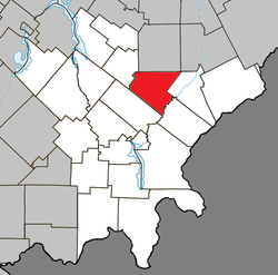 Location within Le Granit RCM | |
 Lac-Drolet Location in southern Quebec | |
| Coordinates: 45°43′N 70°51′W / 45.72°N 70.85°WCoordinates: 45°43′N 70°51′W / 45.72°N 70.85°W[1] | |
| Country |
|
| Province |
|
| Region | Estrie |
| RCM | Le Granit |
| Constituted | January 1, 1885 |
| Government[2] | |
| • Mayor | Marielle Fecteau |
| • Federal riding | Mégantic—L'Érable |
| • Prov. riding | Mégantic |
| Area[2][3] | |
| • Total | 128.20 km2 (49.50 sq mi) |
| • Land | 124.08 km2 (47.91 sq mi) |
| Population (2011)[3] | |
| • Total | 1,071 |
| • Density | 8.6/km2 (22/sq mi) |
| • Pop 2006-2011 |
|
| • Dwellings | 618 |
| Time zone | UTC−5 (EST) |
| • Summer (DST) | UTC−4 (EDT) |
| Postal code(s) | G0Y 1C0 |
| Area code(s) | 819 |
| Highways | No major routes |
| Website |
lacdrolet |
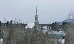
Lac-Drolet is a municipality in the Municipalité régionale de comté du Granit in Estrie, Quebec, Canada. Population is 1,108 as of 2006.
The minor Battle of the Chaudière, opposing British police and Lower Canadian rebels, was fought at Lac-Drolet during the Patriots' War in 1838. The battle had little incidence on the war, and about 50 rebels were captured and three were hanged.
Sources
External links

- Commission de toponymie du Québec
- Ministère des Affaires municipales, des Régions et de l'Occupation du territoire
Places adjacent to Lac-Drolet, Quebec | |
|---|---|
| Cities | |
|---|---|
| Municipalities | |
| Parishes | |
| Townships | |
| |
This article is issued from
Wikipedia.
The text is licensed under Creative Commons - Attribution - Sharealike.
Additional terms may apply for the media files.