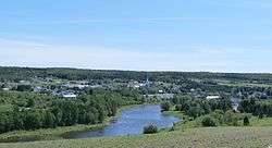
Saint-Ludger, Quebec
| Saint-Ludger | |
|---|---|
| Municipality | |
 | |
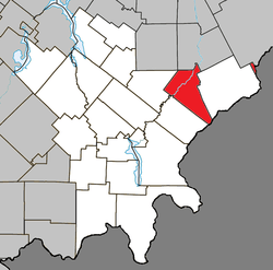 Location within Le Granit RCM | |
 Saint-Ludger Location in southern Quebec | |
| Coordinates: 45°45′N 70°42′W / 45.75°N 70.7°WCoordinates: 45°45′N 70°42′W / 45.75°N 70.7°W[1] | |
| Country |
|
| Province |
|
| Region | Beauce |
| RCM | Le Granit |
| Constituted | February 25, 1998 |
| Government[2] | |
| • Mayor | Diane Roy |
| • Federal riding | Beauce |
| • Prov. riding | Beauce-Sud |
| Area[2][3] | |
| • Total | 128.70 km2 (49.69 sq mi) |
| • Land | 127.69 km2 (49.30 sq mi) |
| Population (2011)[3] | |
| • Total | 1,255 |
| • Density | 9.8/km2 (25/sq mi) |
| • Pop 2006-2011 |
|
| • Dwellings | 565 |
| Time zone | UTC−5 (EST) |
| • Summer (DST) | UTC−4 (EDT) |
| Postal code(s) | G0M 1W0 |
| Area code(s) | 819 |
| Highways |
|
| Website |
www |
Saint-Ludger is a municipality in the Le Granit Regional County Municipality in Beauce, Quebec, Canada, on the Canada–United States border. Population is 1,197 as of 2006.
The municipality of Saint-Ludger was created in 1998 from the amalgamation of the village of Saint-Ludger, the municipality of Risborough and the township of Gayhurst-Partie-Sud-Est. The first settlers arrived in the area before 1863. It is named in honour of Ludger of Utrecht, the first bishop of Münster in the 9th century.
References
External links

- Municipalité de Saint-Ludger (in French)
- Commission de toponymie du Québec
- Ministère des Affaires municipales, des Régions et de l'Occupation du territoire
Places adjacent to Saint-Ludger, Quebec | |
|---|---|
| Cities | |
|---|---|
| Municipalities | |
| Parishes | |
| Townships | |
| |
This article is issued from
Wikipedia.
The text is licensed under Creative Commons - Attribution - Sharealike.
Additional terms may apply for the media files.