Méry-sur-Oise
| Méry-sur-Oise | |
|---|---|
| Commune | |
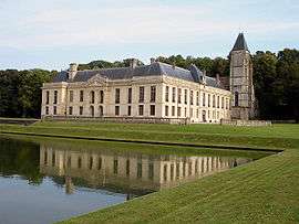 Château de Méry | |
 Méry-sur-Oise Location within Île-de-France region  Méry-sur-Oise | |
| Coordinates: 49°03′52″N 2°11′14″E / 49.0644°N 2.1872°ECoordinates: 49°03′52″N 2°11′14″E / 49.0644°N 2.1872°E | |
| Country | France |
| Region | Île-de-France |
| Department | Val-d'Oise |
| Arrondissement | Pontoise |
| Canton | Saint-Ouen-l'Aumône |
| Intercommunality | Vallée de l'Oise et des Impressionnistes |
| Government | |
| • Mayor (2014–2020) | Pierre-Édouard Eon |
| Area1 | 11.17 km2 (4.31 sq mi) |
| Population (2013)2 | 9,237 |
| • Density | 830/km2 (2,100/sq mi) |
| Time zone | UTC+1 (CET) |
| • Summer (DST) | UTC+2 (CEST) |
| INSEE/Postal code | 95394 /95540 |
| Elevation | 22–96 m (72–315 ft) |
|
1 French Land Register data, which excludes lakes, ponds, glaciers > 1 km2 (0.386 sq mi or 247 acres) and river estuaries. 2 Population without double counting: residents of multiple communes (e.g., students and military personnel) only counted once. | |
Méry-sur-Oise is a commune in the Val-d'Oise department in Île-de-France in northern France.
See also
References
- INSEE
- Association of Mayors of the Val d’Oise (in French)
External links
| Wikimedia Commons has media related to Méry-sur-Oise. |
- Official website (in French)
- Mérimée database - Cultural heritage (in French)
- Land use (IAURIF) (in English)
This article is issued from
Wikipedia.
The text is licensed under Creative Commons - Attribution - Sharealike.
Additional terms may apply for the media files.