Ronquerolles
| Ronquerolles | ||
|---|---|---|
| Commune | ||
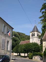 Town hall and the church | ||
| ||
 Ronquerolles Location within Île-de-France region  Ronquerolles | ||
| Coordinates: 49°10′03″N 2°13′31″E / 49.1675°N 2.2253°ECoordinates: 49°10′03″N 2°13′31″E / 49.1675°N 2.2253°E | ||
| Country | France | |
| Region | Île-de-France | |
| Department | Val-d'Oise | |
| Arrondissement | Pontoise | |
| Canton | L'Isle-Adam | |
| Intercommunality | Haut Val-d'Oise | |
| Government | ||
| • Mayor (2014–2020) | Jean-Marie Duhamel | |
| Area1 | 4.74 km2 (1.83 sq mi) | |
| Population (2013)2 | 857 | |
| • Density | 180/km2 (470/sq mi) | |
| Time zone | UTC+1 (CET) | |
| • Summer (DST) | UTC+2 (CEST) | |
| INSEE/Postal code | 95529 /95340 | |
| Elevation | 44–188 m (144–617 ft) | |
|
1 French Land Register data, which excludes lakes, ponds, glaciers > 1 km2 (0.386 sq mi or 247 acres) and river estuaries. 2 Population without double counting: residents of multiple communes (e.g., students and military personnel) only counted once. | ||
.svg.png)
Ronquerolles is a commune in the Val-d'Oise department and Île-de-France region of France.
See also
References
- INSEE
- Association of Mayors of the Val d’Oise (in French)
External links
- Official website (in French)
- Mérimée database - Cultural heritage (in French)
- Land use (IAURIF) (in English)
| Wikimedia Commons has media related to Ronquerolles (Val-d'Oise). |
This article is issued from
Wikipedia.
The text is licensed under Creative Commons - Attribution - Sharealike.
Additional terms may apply for the media files.