Melbourne tram route 70
| Route 70 | |||
|---|---|---|---|
| Waterfront City Docklands - Wattle Park | |||
|
| |||
 | |||
 | |||
| Overview | |||
| System | Melbourne | ||
| Operator | Yarra Trams | ||
| Depot | Camberwell | ||
| Vehicle |
A Class B2 Class | ||
| Route | |||
| Locale | Melbourne, Australia | ||
| Start | Waterfront City Docklands | ||
| Via |
Docklands Melbourne CBD (Flinders St) Richmond Burnley Hawthorn Hawthorn East Camberwell Surrey Hills | ||
| End | Wattle Park | ||
| Length | 16.5 km (10.3 mi) | ||
| Service | |||
| Journey time | 45-65 minutes | ||
| Operates | Daily | ||
| Zone(s) |
Free Zone: Stops D11-D6, 1-7 Myki Zone 1: Stops 8-61 | ||
| Annual patronage | 5.4 million | ||
| Timetable | Route 70 timetable | ||
| Map | Route 70 map | ||
| |||
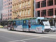
Melbourne tram route 70 is operated by Yarra Trams on the Melbourne tram network. It operates from Waterfront City Docklands to Wattle Park. The 16.5 kilometre route is operated by A and B class trams from Camberwell depot.[1][2]
History
Most of the line currently used by route 70 was initially built and run by the Hawthorn Tramways Trust in 1916–17. It ran between the Batman Avenue terminus (opposite Flinders Street Station) to the intersection of Warrigul Road (then Boundary Road) and Riversdale Road. At the time, the HTT's Batman Avenue line was Melbourne's only electric tram line that reached the CBD. The Melbourne and Metropolitan Traways Board took over the line in 1920, and in 1928, extended the line a further 2 kilometers to Wattle Park at the Riversdale Road and Elgar Road intersection. [3] The track was extended a further to 1.9 kilometres to Wattle Park on 1 July 1928, by which stage it had been taken over by the Melbourne & Metropolitan Tramways Board.[4] In 1934, the line was given the Route 70 designation, which it still holds today. [4][5]
On 6 June 1999 it was diverted to operate via the Exhibition Street extension with a four-lane divided road built over the Jolimont Yard, enabling Batman Avenue west of Melbourne Park to be closed with route 70 extended to terminate at the intersection of Flinders and Spencer Streets. This new route was better able to serve all of the Melbourne Park venues such as the MCG and Rod laver Arena. Extra sidings were also built along the route in order to accommodate special events.[6][7] On 5 January 2005, Route 70 was extended to Docklands Stadium, coinciding with the opening of the Docklands Drive tramway. Finally, on 20 September 2009, Route 70 was extended along Docklands Drive to its current route, where it terminates at Waterfront City.
| Dates | Route | Notes |
|---|---|---|
| 9 December 1934 - 5 June 1999 | Wattle Park to City (Batman Avenue) | |
| 6 June 1999 - 4 January 2005 | Wattle Park to City (Flinders/Spencer Street) | |
| 5 January 2005 - 19 September 2009 | Wattle Park to Etihad Stadium Docklands | |
| 20 September 2009 - onwards | Wattle Park to Waterfront City Docklands | |
Operation
Route 70 is run from Camberwell depot[8] and is predominantly run with A class trams, although B class trams are occasionally used. During the Australian Open, all services are run with B-class trams.
Route and Map
From Waterfront City Docklands, the route runs along Docklands Drive, Harbour Esplanade and Flinders Street in the city, behind Melbourne Park at Richmond and then along Swan Street and Riversdale Road through Hawthorn and Camberwell to the eastern end of Wattle Park, terminating at Elgar Road.
Route 70 | |||||||||||||||||||||||||||||||||||||||||||||||||||||||||||||||||||||||||||||||||||||||||||||||||||||||||||||||||||||||||||||||||||||||||||||||||||||||||||||||||||||||||||||||||||||||||||||||||||||||||||||||||||||||||||||||||||||||||||||||||||||||||||||||||||||||||||||||||||||||||||||||||||||||||||||||||||||||||||||||||||||||||||||||||||||||||||||||||||||||||||||||||||||||||||||||||||||||||||||||||||||||||||||||||||||||||||||||||||||||||||||||||||||||||||||||||||||||||||||||||||||||||||||||||||||||||||||||||||||||||||||||||||||||||||||||||||||||||||||||||||||||||||||||||||||||||||||||||||||||||||||||||||||||||||||||||||||||||||||||||||||||||||||||||||||||||||||||||||||||||||||||||||||||||||||||||||||||||||||||||||||||||||||||||||||||||||||||||||||||||||||||||||||||||||||||||||||||||||||||||||||||||||
|---|---|---|---|---|---|---|---|---|---|---|---|---|---|---|---|---|---|---|---|---|---|---|---|---|---|---|---|---|---|---|---|---|---|---|---|---|---|---|---|---|---|---|---|---|---|---|---|---|---|---|---|---|---|---|---|---|---|---|---|---|---|---|---|---|---|---|---|---|---|---|---|---|---|---|---|---|---|---|---|---|---|---|---|---|---|---|---|---|---|---|---|---|---|---|---|---|---|---|---|---|---|---|---|---|---|---|---|---|---|---|---|---|---|---|---|---|---|---|---|---|---|---|---|---|---|---|---|---|---|---|---|---|---|---|---|---|---|---|---|---|---|---|---|---|---|---|---|---|---|---|---|---|---|---|---|---|---|---|---|---|---|---|---|---|---|---|---|---|---|---|---|---|---|---|---|---|---|---|---|---|---|---|---|---|---|---|---|---|---|---|---|---|---|---|---|---|---|---|---|---|---|---|---|---|---|---|---|---|---|---|---|---|---|---|---|---|---|---|---|---|---|---|---|---|---|---|---|---|---|---|---|---|---|---|---|---|---|---|---|---|---|---|---|---|---|---|---|---|---|---|---|---|---|---|---|---|---|---|---|---|---|---|---|---|---|---|---|---|---|---|---|---|---|---|---|---|---|---|---|---|---|---|---|---|---|---|---|---|---|---|---|---|---|---|---|---|---|---|---|---|---|---|---|---|---|---|---|---|---|---|---|---|---|---|---|---|---|---|---|---|---|---|---|---|---|---|---|---|---|---|---|---|---|---|---|---|---|---|---|---|---|---|---|---|---|---|---|---|---|---|---|---|---|---|---|---|---|---|---|---|---|---|---|---|---|---|---|---|---|---|---|---|---|---|---|---|---|---|---|---|---|---|---|---|---|---|---|---|---|---|---|---|---|---|---|---|---|---|---|---|---|---|---|---|---|---|---|---|---|---|---|---|---|---|---|---|---|---|---|---|---|---|---|---|---|---|---|---|---|---|---|---|---|---|---|---|---|---|---|---|---|---|---|---|---|---|---|---|---|---|---|---|---|---|---|---|---|---|---|---|---|---|---|---|---|---|---|---|---|---|---|---|---|---|---|---|---|---|---|---|---|---|---|---|---|---|---|---|---|---|---|---|---|---|---|---|---|---|---|---|---|---|---|---|---|---|---|---|---|---|---|---|---|---|---|---|---|---|---|---|---|---|---|---|---|---|---|---|---|---|---|---|---|---|---|---|---|---|---|---|---|---|---|---|---|---|---|---|---|---|---|---|---|---|---|---|---|---|---|---|---|---|---|---|---|---|---|---|---|---|---|---|---|---|---|---|---|---|---|---|---|---|---|---|---|---|---|---|---|---|---|---|---|---|---|---|---|---|---|---|---|---|---|---|---|---|---|---|---|---|---|---|---|---|---|---|---|---|---|---|---|---|---|---|---|---|---|---|---|---|---|---|---|---|---|---|---|---|---|---|---|---|---|---|---|---|---|---|---|---|---|---|---|---|---|---|---|---|---|---|---|---|---|---|---|---|---|---|---|---|---|---|---|---|---|---|---|---|---|---|---|---|---|---|---|---|---|---|---|---|---|---|---|---|---|---|---|---|---|---|---|---|---|---|---|---|---|---|---|---|---|---|---|---|---|---|---|---|---|---|---|---|---|---|---|---|---|---|---|---|---|---|---|---|---|---|---|---|---|---|---|---|---|---|---|---|---|---|---|---|---|---|---|---|---|---|---|---|---|---|---|---|---|---|---|---|---|---|---|---|---|---|---|---|---|---|---|---|---|---|---|---|---|---|---|---|---|---|---|---|---|---|---|---|---|---|---|---|---|---|---|---|---|---|---|---|---|---|---|---|---|
| Wattle Park - Waterfront City Docklands via Surrey Hills, Richmond and City Free Tram Zone covers stops D11 to 6. Fare zone 1 applies from stop 7A to 61. | |||||||||||||||||||||||||||||||||||||||||||||||||||||||||||||||||||||||||||||||||||||||||||||||||||||||||||||||||||||||||||||||||||||||||||||||||||||||||||||||||||||||||||||||||||||||||||||||||||||||||||||||||||||||||||||||||||||||||||||||||||||||||||||||||||||||||||||||||||||||||||||||||||||||||||||||||||||||||||||||||||||||||||||||||||||||||||||||||||||||||||||||||||||||||||||||||||||||||||||||||||||||||||||||||||||||||||||||||||||||||||||||||||||||||||||||||||||||||||||||||||||||||||||||||||||||||||||||||||||||||||||||||||||||||||||||||||||||||||||||||||||||||||||||||||||||||||||||||||||||||||||||||||||||||||||||||||||||||||||||||||||||||||||||||||||||||||||||||||||||||||||||||||||||||||||||||||||||||||||||||||||||||||||||||||||||||||||||||||||||||||||||||||||||||||||||||||||||||||||||||||||||||||
| |||||||||||||||||||||||||||||||||||||||||||||||||||||||||||||||||||||||||||||||||||||||||||||||||||||||||||||||||||||||||||||||||||||||||||||||||||||||||||||||||||||||||||||||||||||||||||||||||||||||||||||||||||||||||||||||||||||||||||||||||||||||||||||||||||||||||||||||||||||||||||||||||||||||||||||||||||||||||||||||||||||||||||||||||||||||||||||||||||||||||||||||||||||||||||||||||||||||||||||||||||||||||||||||||||||||||||||||||||||||||||||||||||||||||||||||||||||||||||||||||||||||||||||||||||||||||||||||||||||||||||||||||||||||||||||||||||||||||||||||||||||||||||||||||||||||||||||||||||||||||||||||||||||||||||||||||||||||||||||||||||||||||||||||||||||||||||||||||||||||||||||||||||||||||||||||||||||||||||||||||||||||||||||||||||||||||||||||||||||||||||||||||||||||||||||||||||||||||||||||||||||||||||
| Note: Green denotes free tram zone | |||||||||||||||||||||||||||||||||||||||||||||||||||||||||||||||||||||||||||||||||||||||||||||||||||||||||||||||||||||||||||||||||||||||||||||||||||||||||||||||||||||||||||||||||||||||||||||||||||||||||||||||||||||||||||||||||||||||||||||||||||||||||||||||||||||||||||||||||||||||||||||||||||||||||||||||||||||||||||||||||||||||||||||||||||||||||||||||||||||||||||||||||||||||||||||||||||||||||||||||||||||||||||||||||||||||||||||||||||||||||||||||||||||||||||||||||||||||||||||||||||||||||||||||||||||||||||||||||||||||||||||||||||||||||||||||||||||||||||||||||||||||||||||||||||||||||||||||||||||||||||||||||||||||||||||||||||||||||||||||||||||||||||||||||||||||||||||||||||||||||||||||||||||||||||||||||||||||||||||||||||||||||||||||||||||||||||||||||||||||||||||||||||||||||||||||||||||||||||||||||||||||||||
References
- ↑ Facts & figures Yarra Trams
- ↑ Route 70 Yarra Trams
- ↑ "Camberwell City Council". Camberwell and Hawthorn Advertiser. 2 June 1917. Retrieved 9 September 2017.
- 1 2 "Melbourne's Two Batman Avenue Tramways 1916 and 1999" Trolley Wire issue 278 August 1999 pages 3–15
- ↑ "Exhibition Street Extension Opening" (PDF). www.transurban.com.au. 26 October 1999. Archived from the original (PDF) on 20 July 2008. Retrieved 2008-07-17.
- ↑ Changes to Routes 48 & 70 from Sunday 20 September 2009 Yarra Trams
- ↑ History of Melbourne Trams Routes from 1950 to 2009 Yarra Trams
- ↑ "Camberwell Depot", Vicsig, retrieved 10 October 2011
External links

- Route 70 map
- Route 70 timetable