Melbourne tram route 64
| Route 64 | |||
|---|---|---|---|
| Melbourne University - Brighton East | |||
|
| |||
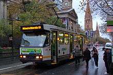 A2 Class tram on Swanston Street in May 2012 | |||
| Overview | |||
| System | Melbourne | ||
| Operator | Yarra Trams | ||
| Depot | Glenhuntly | ||
| Vehicle |
Z3 Class A Class B2 Class | ||
| Began service | 16 October 1938 | ||
| Route | |||
| Length | 16.1 km (10.0 mi) | ||
| Timetable | Route 64 timetable | ||
| Map | Route 64 map | ||
| |||
Melbourne tram route 64 is operated by Yarra Trams on the Melbourne tram network. It operates from Melbourne University to Brighton East via Windsor and Caulfield. The 18.1 kilometre route is operated by Z, A and B class trams from Glenhuntly depot.[1][2]
After 19:00, passengers for route 5 to Malvern are required to board route 64 (marked 64/5) and transfer to route 5 shuttles on Dandenong Road.
History
Route 64 was allocated to the line between East Brighton and City (Swanston Street) on 16 October 1938. Prior to that, Route 64 was allocated to the line between East Brighton and St Kilda Beach via St Kilda Junction.[3] Between 1938 and 9 July 1955, Route 64 ran via Balaclava Road rather than Dandenong Road. Trams traditionally terminated at the Victoria St terminus, but following an accident in 1991, trams instead terminated at the Queensberry St crossover. Due to congestion during peak hours at the crossover, some trams continued north to Melbourne University. Finally on 17 January 1996, a permanent shunt was built at Melbourne University.[3] From then on, Route 64 trams were altered run full-time to Melbourne University.
The origins of route 5 lie in separate tram lines. The section of track between Queensberry Street (Stop 4) and St Kilda Road (Stop 30) is the oldest section of this route, dating back to the Brighton Road cable tram which opened on 11 October 1888 by the Melbourne Tramway & Omnibus Company. This cable tram line was electrified in stages by the Melbourne & Metropolitan Tramways Board (MMTB).[3] The section between Domain Interchange (Stop 20) and St Kilda Junction (Stop 30) was electrified on 27 December 1925. The section between Queensberry Street and City Road (near Stop 14) was electrified on the same day. The line between City Road and Domain Interchange was electrified on 24 January 1926. The section between St Kilda Junction and Chapel Street (Stop 32) also dates back to the cable era, as the Windsor to St Kilda Esplanade cable tramway which opened on 17 October 1891. This section was one the first cable tram to be converted to electric traction on 27 December 1925.[3]
The Prahran & Malvern Tramway Trust (PMTT) built the section between the Sandringham railway line (near Stop 33) and Hawthorn Road (Stop 48), opening on 16 December 1911. This line was extended to Chapel Street (Stop 32) on 31 March 1912. The line between Hawthorn Road and Balaclava Road (Stop 51) opened on 12 April 1913. This was later extended to Glenhuntly Road (Stop 57) on 13 November 1913. Further extensions of the Hawthorn Road line were built by the MMTB to North Road (on 1 March 1925), and to Point Nepean Road on 5 December 1937.[3]
As part of the St Kilda Junction separation works, the Wellington Street section was abandoned for a new section of track along the newly created Queens Way on 4 November 1968.[3]
| Dates | Route | Notes |
|---|---|---|
| 24 June 1934 - 4 December 1937 | Brighton Cemetery to St Kilda Beach | via Dandenong Road |
| 5 December 1937 - 15 October 1938 | East Brighton to St Kilda Beach | via Dandenong Road |
| 16 October 1938 - 9 July 1955 | East Brighton to City (Victoria/Swanston Streets) | via Balaclava Road |
| 10 July 1955 - 14 April 1991 | East Brighton to City (Victoria Street) | via Dandenong Road; Rerouted to Queens Way on 11 April 1968 |
| 15 April 1991 - 16 January 1996 | East Brighton to City (Queensberry/Swanston Streets) | via Dandenong Road |
| 17 January 1996 - present | East Brighton to Melbourne University | via Dandenong Road |
Operation
Route 64 is mainly run with Z, A, and B class trams from Glenhuntly depot.[2]
Route map
Melbourne Tram Route 64 | |||||||||||||||||||||||||||||||||||||||||||||||||||||||||||||||||||||||||||||||||||||||||||||||||||||||||||||||||||||||||||||||||||||||||||||||||||||||||||||||||||||||||||||||||||||||||||||||||||||||||||||||||||||||||||||||||||||||||||||||||||||||||||||||||||||||||||||||||||||||||||||||||||||||||||||||||||||||||||||||||||||||||||||||||||||||||||||||||||||||||||||||||||||||||||||||||||||||||||||||||||||||||||||||||||||||||||||||||||||||||||||||||||||||||||||||||||||||||||||||||||||||||||||||||||||||||||||||||||||||||||||||||||||||||||||||||||||||||||||||||||||||||||||||||||||||||||||||||||||||||||||||||||||||||||||||||||||||||||||||||||||||||||||||||||||||||||||||||||||||||||||||||||||||||||||||||||||||||||||||||||||||||||||||||||||||||||||||||||||||||||||||||||||||||||||||||||||||
|---|---|---|---|---|---|---|---|---|---|---|---|---|---|---|---|---|---|---|---|---|---|---|---|---|---|---|---|---|---|---|---|---|---|---|---|---|---|---|---|---|---|---|---|---|---|---|---|---|---|---|---|---|---|---|---|---|---|---|---|---|---|---|---|---|---|---|---|---|---|---|---|---|---|---|---|---|---|---|---|---|---|---|---|---|---|---|---|---|---|---|---|---|---|---|---|---|---|---|---|---|---|---|---|---|---|---|---|---|---|---|---|---|---|---|---|---|---|---|---|---|---|---|---|---|---|---|---|---|---|---|---|---|---|---|---|---|---|---|---|---|---|---|---|---|---|---|---|---|---|---|---|---|---|---|---|---|---|---|---|---|---|---|---|---|---|---|---|---|---|---|---|---|---|---|---|---|---|---|---|---|---|---|---|---|---|---|---|---|---|---|---|---|---|---|---|---|---|---|---|---|---|---|---|---|---|---|---|---|---|---|---|---|---|---|---|---|---|---|---|---|---|---|---|---|---|---|---|---|---|---|---|---|---|---|---|---|---|---|---|---|---|---|---|---|---|---|---|---|---|---|---|---|---|---|---|---|---|---|---|---|---|---|---|---|---|---|---|---|---|---|---|---|---|---|---|---|---|---|---|---|---|---|---|---|---|---|---|---|---|---|---|---|---|---|---|---|---|---|---|---|---|---|---|---|---|---|---|---|---|---|---|---|---|---|---|---|---|---|---|---|---|---|---|---|---|---|---|---|---|---|---|---|---|---|---|---|---|---|---|---|---|---|---|---|---|---|---|---|---|---|---|---|---|---|---|---|---|---|---|---|---|---|---|---|---|---|---|---|---|---|---|---|---|---|---|---|---|---|---|---|---|---|---|---|---|---|---|---|---|---|---|---|---|---|---|---|---|---|---|---|---|---|---|---|---|---|---|---|---|---|---|---|---|---|---|---|---|---|---|---|---|---|---|---|---|---|---|---|---|---|---|---|---|---|---|---|---|---|---|---|---|---|---|---|---|---|---|---|---|---|---|---|---|---|---|---|---|---|---|---|---|---|---|---|---|---|---|---|---|---|---|---|---|---|---|---|---|---|---|---|---|---|---|---|---|---|---|---|---|---|---|---|---|---|---|---|---|---|---|---|---|---|---|---|---|---|---|---|---|---|---|---|---|---|---|---|---|---|---|---|---|---|---|---|---|---|---|---|---|---|---|---|---|---|---|---|---|---|---|---|---|---|---|---|---|---|---|---|---|---|---|---|---|---|---|---|---|---|---|---|---|---|---|---|---|---|---|---|---|---|---|---|---|---|---|---|---|---|---|---|---|---|---|---|---|---|---|---|---|---|---|---|---|---|---|---|---|---|---|---|---|---|---|---|---|---|---|---|---|---|---|---|---|---|---|---|---|---|---|---|---|---|---|---|---|---|---|---|---|---|---|---|---|---|---|---|---|---|---|---|---|---|---|---|---|---|---|---|---|---|---|---|---|---|---|---|---|---|---|---|---|---|---|---|---|---|---|---|---|---|---|---|---|---|---|---|---|---|---|---|---|---|---|---|---|---|---|---|---|---|---|---|---|---|---|---|---|---|---|---|---|---|---|---|---|---|---|---|---|---|---|---|---|---|---|---|---|---|---|---|---|---|---|---|---|---|---|---|---|---|---|---|---|---|---|---|---|---|---|---|---|---|---|---|---|---|---|---|---|---|---|---|---|---|---|---|---|---|---|---|---|---|---|---|---|---|---|---|---|---|---|---|---|---|---|---|---|---|---|---|---|---|---|---|---|---|---|---|---|---|---|
| Melbourne University - East Brighton via City, Windsor and Caulfield South Free Tram Zone covers stops 8 to 13. Fare zone 1 applies from stop 1 to 7, 14 to 68. | |||||||||||||||||||||||||||||||||||||||||||||||||||||||||||||||||||||||||||||||||||||||||||||||||||||||||||||||||||||||||||||||||||||||||||||||||||||||||||||||||||||||||||||||||||||||||||||||||||||||||||||||||||||||||||||||||||||||||||||||||||||||||||||||||||||||||||||||||||||||||||||||||||||||||||||||||||||||||||||||||||||||||||||||||||||||||||||||||||||||||||||||||||||||||||||||||||||||||||||||||||||||||||||||||||||||||||||||||||||||||||||||||||||||||||||||||||||||||||||||||||||||||||||||||||||||||||||||||||||||||||||||||||||||||||||||||||||||||||||||||||||||||||||||||||||||||||||||||||||||||||||||||||||||||||||||||||||||||||||||||||||||||||||||||||||||||||||||||||||||||||||||||||||||||||||||||||||||||||||||||||||||||||||||||||||||||||||||||||||||||||||||||||||||||||||||||||||||
| |||||||||||||||||||||||||||||||||||||||||||||||||||||||||||||||||||||||||||||||||||||||||||||||||||||||||||||||||||||||||||||||||||||||||||||||||||||||||||||||||||||||||||||||||||||||||||||||||||||||||||||||||||||||||||||||||||||||||||||||||||||||||||||||||||||||||||||||||||||||||||||||||||||||||||||||||||||||||||||||||||||||||||||||||||||||||||||||||||||||||||||||||||||||||||||||||||||||||||||||||||||||||||||||||||||||||||||||||||||||||||||||||||||||||||||||||||||||||||||||||||||||||||||||||||||||||||||||||||||||||||||||||||||||||||||||||||||||||||||||||||||||||||||||||||||||||||||||||||||||||||||||||||||||||||||||||||||||||||||||||||||||||||||||||||||||||||||||||||||||||||||||||||||||||||||||||||||||||||||||||||||||||||||||||||||||||||||||||||||||||||||||||||||||||||||||||||||||
References
External links

- Route 64 map
- Route 64 timetable