Mühlberg, Brandenburg
| Mühlberg | ||
|---|---|---|
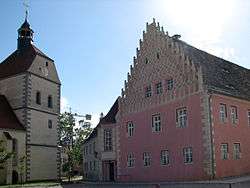 Church and town hall | ||
| ||
 Mühlberg Location of Mühlberg within Elbe-Elster district 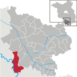 | ||
| Coordinates: 51°25′59″N 13°13′00″E / 51.43306°N 13.21667°ECoordinates: 51°25′59″N 13°13′00″E / 51.43306°N 13.21667°E | ||
| Country | Germany | |
| State | Brandenburg | |
| District | Elbe-Elster | |
| Government | ||
| • Mayor | Hannelore Brendel | |
| Area | ||
| • Total | 88.55 km2 (34.19 sq mi) | |
| Elevation | 91 m (299 ft) | |
| Population (2017-12-31)[1] | ||
| • Total | 3,745 | |
| • Density | 42/km2 (110/sq mi) | |
| Time zone | CET/CEST (UTC+1/+2) | |
| Postal codes | 04931 | |
| Dialling codes | 035342 | |
| Vehicle registration | EE | |
| Website | www.muehlberg-elbe.de | |

Mühlberg is a town in the Elbe-Elster district, in the southwesternmost part of Brandenburg, Germany. It is located on the right bank of the river Elbe, about halfway between Riesa to the south and Torgau to the northwest. It is about 60 km east of Leipzig. It is accessed by the Bundesstraße 182 (Riesa - Torgau - Wittenberg) on the left bank of the Elbe, connected with the town by a bridge, opened in 2008. Mühlberg consists of the Ortsteile Mühlberg, Altenau, Brottewitz, Fichtenberg, Koßdorf and Martinskirchen.
History
The earliest documentary mention of Mühlberg is in 1230. The town was founded on a sandy island where the River Elbe could be crossed under protection of a castle. There is archaeological evidence, in the form of burials, of Slavic settlement dating back to ca. 600 A.D. The forces of Charles V, Holy Roman Emperor defeated the Schmalkaldic League at the Battle of Mühlberg near the castle on April 24, 1547. From 1939-1945 there existed a World War II prisoner-of-war camp (Stalag IV-B) near Mühlberg. About 300000 prisoners passed the camp and about 3000, most of them Soviet soldiers, died there. After World War II the camp was re-used by the Soviet secret service NKVD as NKVD Special Camp No. 1. About 6700 of the 22000 prisoners of the NKVD are buried in mass graves near the camp area. Today a memorial area remembers on the victims of both camp periods.
Demography
 Development of Population since 1875 within the Current Boundaries (Blue Line: Population; Dotted Line: Comparison to Population Development of Brandenburg state; Grey Background: Time of Nazi rule; Red Background: Time of Communist rule)
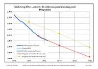 Recent Population Development and Projections (Population Development before Census 2011 (blue line); Recent Population Development according to the Census in Germany in 2011 (blue bordered line); Projection by the Brandenburg state for 2005-2030 (yellow line); Projection by the Brandenburg state for 2014-2030 (red line))
| Mühlberg/Elbe: Population development within the current boundaries (2017)[2] | ||||||||||||||||||||||||||||||||||||||||||||||||||||||||||||||||||||||||||||||||||||||||||||||||||||||||||||||||||||||||||||||||||||||
|---|---|---|---|---|---|---|---|---|---|---|---|---|---|---|---|---|---|---|---|---|---|---|---|---|---|---|---|---|---|---|---|---|---|---|---|---|---|---|---|---|---|---|---|---|---|---|---|---|---|---|---|---|---|---|---|---|---|---|---|---|---|---|---|---|---|---|---|---|---|---|---|---|---|---|---|---|---|---|---|---|---|---|---|---|---|---|---|---|---|---|---|---|---|---|---|---|---|---|---|---|---|---|---|---|---|---|---|---|---|---|---|---|---|---|---|---|---|---|---|---|---|---|---|---|---|---|---|---|---|---|---|---|---|---|
|
|
| ||||||||||||||||||||||||||||||||||||||||||||||||||||||||||||||||||||||||||||||||||||||||||||||||||||||||||||||||||||||||||||||||||||
Sites of interest
- Marienstern Abbey
- Castle
- Historic town centre of Mühlberg
- Museum dedicated to the battle that took place in 1547[3].
Personalities
- Wilhelm Hasemann (1850-1913), Black Forest painter
- Werner Kube (1924-1945), resistance fighter, shot 1945 in Brottewitz
References
- ↑ "Bevölkerung im Land Brandenburg nach amtsfreien Gemeinden, Ämtern und Gemeinden 31. Dezember 2017 (Fortgeschriebene amtliche Einwohnerzahlen auf Grundlage des Zensus 2011)". Amt für Statistik Berlin-Brandenburg (in German). 2018.
- ↑ Detailed data sources are to be found in the Wikimedia Commons.Population Projection Brandenburg at Wikimedia Commons
- ↑ "Museum Mühlberg 1547". www.luther2017.de. Retrieved 18 August 2018.
External links
| Wikimedia Commons has media related to Mühlberg. |

- Website on the history of POW camp Stalag IVb and Soviet special camp No.1 near Mühlberg
| Authority control |
|---|