Demography
Fichtwald: Population development
within the current boundaries (2017)[2] |
|---|
| Year | Pop. | ±% p.a. |
|---|
| 1875 | 970 | — |
|---|
| 1890 | 980 | +0.07% |
|---|
| 1910 | 960 | −0.10% |
|---|
| 1925 | 1,001 | +0.28% |
|---|
| 1933 | 931 | −0.90% |
|---|
| 1939 | 866 | −1.20% |
|---|
| 1946 | 1,362 | +6.68% |
|---|
| 1950 | 1,333 | −0.54% |
|---|
| 1964 | 1,019 | −1.90% |
|---|
| 1971 | 1,003 | −0.23% |
|---|
| 1981 | 943 | −0.61% |
|---|
| 1985 | 952 | +0.24% |
|---|
| 1989 | 890 | −1.67% |
|---|
| 1990 | 883 | −0.79% |
|---|
| | Year | Pop. | ±% p.a. |
|---|
| 1991 | 854 | −3.28% |
|---|
| 1992 | 851 | −0.35% |
|---|
| 1993 | 841 | −1.18% |
|---|
| 1994 | 845 | +0.48% |
|---|
| 1995 | 843 | −0.24% |
|---|
| 1996 | 833 | −1.19% |
|---|
| 1997 | 817 | −1.92% |
|---|
| 1998 | 813 | −0.49% |
|---|
| 1999 | 813 | +0.00% |
|---|
| 2000 | 804 | −1.11% |
|---|
| 2001 | 802 | −0.25% |
|---|
| 2002 | 780 | −2.74% |
|---|
| 2003 | 775 | −0.64% |
|---|
| 2004 | 759 | −2.06% |
|---|
| | Year | Pop. | ±% p.a. |
|---|
| 2005 | 735 | −3.16% |
|---|
| 2006 | 716 | −2.59% |
|---|
| 2007 | 709 | −0.98% |
|---|
| 2008 | 703 | −0.85% |
|---|
| 2009 | 686 | −2.42% |
|---|
| 2010 | 675 | −1.60% |
|---|
| 2011 | 660 | −2.22% |
|---|
| 2012 | 683 | +3.48% |
|---|
| 2013 | 685 | +0.29% |
|---|
| 2014 | 678 | −1.02% |
|---|
| 2015 | 673 | −0.74% |
|---|
| 2016 | 649 | −3.57% |
|---|
| 2017 | 625 | −3.70% |
|---|
|
External links
 |
Wikimedia Commons has media related to Fichtwald. |

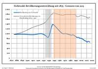 Development of population since 1875 within the current boundaries (Blue line: population; dotted line: Comparison to population development of Brandenburg state; grey background: Time of Nazi rule; red background: Time of communist rule)