Demography
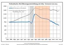
Development of Population since 1875 within the Current Boundaries (Blue Line: Population; Dotted Line: Comparison to Population Development of Brandenburg state; Grey Background: Time of Nazi rule; Red Background: Time of Communist rule)
Hohenbucko:
Population development within the current boundaries (2013)[2]
| Year |
Population |
|---|
| 1875 | 790 |
| 1890 | 790 |
| 1910 | 800 |
| 1925 | 798 |
| 1933 | 811 |
| 1939 | 750 |
| 1946 | 1 152 |
| 1950 | 1 195 |
| 1964 | 1 020 |
| 1971 | 982 |
|
|
| Year |
Population |
|---|
| 1981 | 952 |
| 1985 | 935 |
| 1989 | 903 |
| 1990 | 882 |
| 1991 | 850 |
| 1992 | 843 |
| 1993 | 847 |
| 1994 | 848 |
| 1995 | 838 |
| 1996 | 831 |
|
|
| Year |
Population |
|---|
| 1997 | 809 |
| 1998 | 801 |
| 1999 | 771 |
| 2000 | 778 |
| 2001 | 777 |
| 2002 | 778 |
| 2003 | 749 |
| 2004 | 738 |
| 2005 | 727 |
| 2006 | 712 |
|
|
| Year |
Population |
|---|
| 2007 | 709 |
| 2008 | 696 |
| 2009 | 691 |
| 2010 | 686 |
| 2011 | 683 |
| 2012 | 674 |
| 2013 | 663 |
| 2014 | 655 |
| 2015 | 646 |
| 2016 | 640 |
|
|
References
Authority control  | |
|---|