Bad Liebenwerda
| Bad Liebenwerda | ||
|---|---|---|
 The Lubwartturm, Bad Liebenwerda | ||
| ||
 Bad Liebenwerda Location of Bad Liebenwerda within Elbe-Elster district  | ||
| Coordinates: 51°31′0″N 13°24′0″E / 51.51667°N 13.40000°ECoordinates: 51°31′0″N 13°24′0″E / 51.51667°N 13.40000°E | ||
| Country | Germany | |
| State | Brandenburg | |
| District | Elbe-Elster | |
| Government | ||
| • Mayor | Thomas Richter (CDU) | |
| Area | ||
| • Total | 138.41 km2 (53.44 sq mi) | |
| Elevation | 86 m (282 ft) | |
| Population (2017-12-31)[1] | ||
| • Total | 9,282 | |
| • Density | 67/km2 (170/sq mi) | |
| Time zone | CET/CEST (UTC+1/+2) | |
| Postal codes | 04924 | |
| Dialling codes | 035341 | |
| Vehicle registration | EE, FI, LIB | |
| Website | www.badliebenwerda.de | |

Bad Liebenwerda is a spa town in the Elbe-Elster district, in southwestern Brandenburg, Germany. It is situated on the river Schwarze Elster, 57 km northwest of Dresden, and 28 km east of Torgau.
History
The first written mention is from 1231 as Lievenwerde. The meaning of the name is Live, or Lieb for life or lovely, and -werde from werda meaning island, high place in water. The document of 1231 mentions an Otto of Ileburg, Vogt of Lievenwerde, and Plebanus Walterus, a priest. Liebenwerda has a moated castle with a keep known as the Lubwartturm. The first mention as Liebenwerda as a city is from 1304. Liebenwerda was part of the Electorate of Saxony and Kingdom of Saxony until 1815; as a result of the Congress of Vienna the area became a district in the Kingdom of Prussia. The town has had a health spa since 1905, and in 1925 the word Bad was prefixed to its name.
Demography
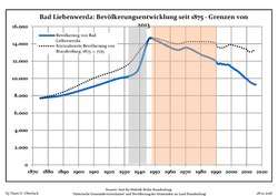 Development of Population since 1875 within the Current Boundaries (Blue Line: Population; Dotted Line: Comparison to Population Development of Brandenburg state; Grey Background: Time of Nazi rule; Red Background: Time of Communist rule)
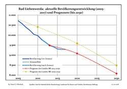 Recent Population Development and Projections (Population Development before Census 2011 (blue line); Recent Population Development according to the Census in Germany in 2011 (blue bordered line); Projection by the Brandenburg state for 2005-2030 (yellow line); Projection by the Brandenburg state for 2014-2030 (red line)
| Bad Liebenwerda: Population development within the current boundaries (2017)[2] | ||||||||||||||||||||||||||||||||||||||||||||||||||||||||||||||||||||||||||||||||||||||||||||||||||||||||||||||||||||||||||||||||||||||
|---|---|---|---|---|---|---|---|---|---|---|---|---|---|---|---|---|---|---|---|---|---|---|---|---|---|---|---|---|---|---|---|---|---|---|---|---|---|---|---|---|---|---|---|---|---|---|---|---|---|---|---|---|---|---|---|---|---|---|---|---|---|---|---|---|---|---|---|---|---|---|---|---|---|---|---|---|---|---|---|---|---|---|---|---|---|---|---|---|---|---|---|---|---|---|---|---|---|---|---|---|---|---|---|---|---|---|---|---|---|---|---|---|---|---|---|---|---|---|---|---|---|---|---|---|---|---|---|---|---|---|---|---|---|---|
|
|
| ||||||||||||||||||||||||||||||||||||||||||||||||||||||||||||||||||||||||||||||||||||||||||||||||||||||||||||||||||||||||||||||||||||
Culture and architecture
Bad Liebenwerda is home of the Gothic church of St. Nikolai. The tower of the church was rebuilt at the end of the 19th century after lightning struck the tower and caused a fire. The Lubwartturm is the oldest building in town. The tower was built around 1207 as part of the moated castle. Next to this tower is the museum with an exhibition on the composer Carl Heinrich Graun and his brothers. Also is there an exhibition on Marionettes, other puppets and puppeteers of south-east Germany. Bad Liebenwerda has a beautiful little park.
 Bad Liebenwerda, former prison
 Bad Liebenwerda, Lubwart-Tower
 central place "Rossmarkt"
Sons and daughters of the town
- Gotthard Fritzsche (1797-1863), theologian and founder of the Evangelical Lutheran Church in Australia
- Ernst Theodor Echtermeyer (1805-1844), philosopher and philologist
- Ernst Eberhard (1843-1909), popular science writer
- Erich Müller (1897-1980), writer
References
- ↑ "Bevölkerung im Land Brandenburg nach amtsfreien Gemeinden, Ämtern und Gemeinden 31. Dezember 2017 (Fortgeschriebene amtliche Einwohnerzahlen auf Grundlage des Zensus 2011)". Amt für Statistik Berlin-Brandenburg (in German). 2018.
- ↑ Detailed data sources are to be found in the Wikimedia Commons.Population Projection Brandenburg at Wikimedia Commons
External links
![]()