Demography
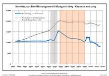
Development of Population since 1875 within the Current Boundaries (Blue Line: Population; Dotted Line: Comparison to Population Development of Brandenburg state; Grey Background: Time of Nazi rule; Red Background: Time of Communist rule)
Kremitzaue:
Population development within the current boundaries (2013)[2]
| Year |
Population |
|---|
| 1875 | 1 060 |
| 1890 | 1 060 |
| 1910 | 1 070 |
| 1925 | 1 067 |
| 1933 | 1 129 |
| 1939 | 1 116 |
| 1946 | 1 532 |
| 1950 | 1 469 |
| 1964 | 1 211 |
| 1971 | 1 194 |
|
|
| Year |
Population |
|---|
| 1981 | 1 143 |
| 1985 | 1 104 |
| 1989 | 1 028 |
| 1990 | 1 024 |
| 1991 | 1 081 |
| 1992 | 1 114 |
| 1993 | 1 248 |
| 1994 | 1 245 |
| 1995 | 1 238 |
| 1996 | 1 232 |
|
|
| Year |
Population |
|---|
| 1997 | 1 236 |
| 1998 | 1 247 |
| 1999 | 1 026 |
| 2000 | 1 018 |
| 2001 | 1 021 |
| 2002 | 1 033 |
| 2003 | 1 018 |
| 2004 | 995 |
| 2005 | 989 |
| 2006 | 976 |
|
|
| Year |
Population |
|---|
| 2007 | 962 |
| 2008 | 947 |
| 2009 | 930 |
| 2010 | 921 |
| 2011 | 876 |
| 2012 | 865 |
| 2013 | 830 |
| 2014 | 828 |
| 2015 | 809 |
| 2016 | 803 |
|
|
References
Authority control  | |
|---|

