Mansehra District
| Mansehra District | |
|---|---|
| District | |
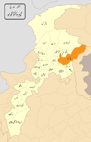 Location of Mansehra District (including Torghar District) within Khyber Pakhtunkhwa prior to 2011. | |
| Country | Pakistan |
| Province | Khyber Pakhtunkhwa |
| Founded by | Raja Man singh |
| Headquarters | Mansehra |
| Government | |
| • Deputy Commissioner (DC) | Engineer Abdul Aamer Khattak(DMG/PAS Officer) |
| Area | |
| • Total | 4,579 km2 (1,768 sq mi) |
| Population (2017)[1] | |
| • Total | 1,556,460 |
| • Density | 340/km2 (880/sq mi) |
| Time zone | UTC+5 (PST) |
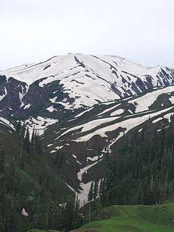
Mansehra District (مانسہرہ) is a district in the Hazara division of Khyber Pakhtunkhwa province of Pakistan. Mansehra district and town are named after Man Singh, a leading general of Mughal Emperor Akbar. It is considered as an important tourist location due to Kaghan Valley area being located in the district and the Karakoram Highway passing through the district.
It was established as a district in 1976, prior to which it was a tehsil within the former Hazara District.[2] Two former subdivisions of Mansehra have been split off into separate districts: Battagram in 1993,[3] and Torghar District (formerly known as Kala Dhaka) – in 2011.
Demographics
The population total for the Mansehra, Balakot and Oghi tehsils counted in the 1998 census was 978,200[4] The predominant language is Hindko, which according to the 1981 census data for the Mansehra Tehsil was the language of communication within 72% of households. Pashto had a share of 14%.[5] There are also speakers of the widely dispersed Gujari language, particularly in the Kaghan Valley.[6] Amb was the great Tanoli princely state in Mansehra till 1973. The local variety is intermediate between the eastern dialects of Gujari (spoken in Azad Kashmir) and the western group (from Chitral, Swat and Gilgit).[7] There is also a small community in the village of Dani in Oghi Tehsil who speak the endangered Mankiyali language.[8]
Constituencies
The district is represented in the Khyber Pakhtunkhwa Assembly by elected MPAs who represent the following constituencies;
- PK 30
- PK 31
- PK 32
- PK 33
- PK 34
The district is represented in the National Assembly of Pakistan by two elected MNAs who represent the following constituencies:
Administrative divisions
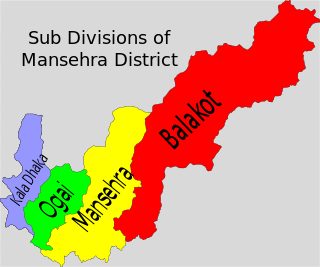
Mansehra District consists of five tehsils.[9]
The Kala Dhaka tehsil was separated as Torghar District in 2011.
Mansehra
Mansehra Tehsil union councils:
|
|
|
References
- ↑ "DISTRICT WISE CENSUS RESULTS CENSUS 2017" (PDF). www.pbscensus.gov.pk.
- ↑ Census report of Mansehra 1998, p. 1.
- ↑ Census report of Batagram 1998, p. 18.
- ↑ Census report of Mansehra 1998, p. 96.
- ↑ Census report of Mansehra 1981, p. 73.
- ↑ Hallberg & O'Leary 1992, p. 96.
- ↑ Hallberg & O'Leary 1992, pp. 112–13, 135. The particular variety studied was from the village of Mittikot, six kilometres west of Balakot.
- ↑ Anjum & Rehman 2015.
- ↑ Mansehra district, Khyber Pakhtunkhwa Tribune, retrieved 19 August 2017.
Bibliography
- 1998 District census report of Batagram. Census publication. 18. Islamabad: Population Census Organization, Statistics Division, Government of Pakistan. 1999.
- 1981 District census report of Mansehra. District Census Report. 23. Islamabad: Population Census Organization, Statistics Division, Government of Pakistan. 1983.
- 1998 District census report of Mansehra. Census publication. 62. Islamabad: Population Census Organization, Statistics Division, Government of Pakistan. 2000.
- Anjum, Uzma; Rehman, Khawaja (2015). "A First Look at Mankiyali Language: An Endangered Language". Journal of Asian Civilizations. 38 (1): 177–90.
- Hallberg, Calinda E.; O'Leary, Clare F. (1992). "Dialect Variation and Multilingualism among Gujars of Pakistan". In O'Leary, Clare F.; Rensch, Calvin R.; Hallberg, Calinda E. Hindko and Gujari. Sociolinguistic Survey of Northern Pakistan. Islamabad: National Institute of Pakistan Studies, Quaid-i-Azam University and Summer Institute of Linguistics. pp. 91–196. ISBN 969-8023-13-5.
Provincial capital: Peshawar | ||
| Divisions | Districts | 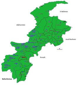 |
| Bannu | ||
| Dera Ismail Khan | ||
| Hazara | ||
| Kohat | ||
| Malakand | ||
| Mardan | ||
| Peshawar | ||