Garhi Habibullah
| Garhi Habibullah meaning Fort of Habibullah Khan گڑھی حبیب اللہ | |
|---|---|
| Union council and town | |
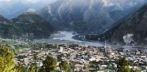 Garhi Habibullah View from Aznali Hills | |
 Garhi Habibullah meaning Fort of Habibullah Khan Location in Pakistan  Garhi Habibullah meaning Fort of Habibullah Khan Garhi Habibullah meaning Fort of Habibullah Khan (Pakistan) | |
| Coordinates: 34°24′05″N 73°22′49″E / 34.4014°N 73.3803°ECoordinates: 34°24′05″N 73°22′49″E / 34.4014°N 73.3803°E | |
| Country | Pakistan |
| Region | Khyber-Pakhtunkhwa |
| District | Mansehra District |
| Time zone | UTC+5 (PST) |
| Area code(s) | 0997 |
Garhi Habibullah is a town and union council (an administrative subdivision) of Mansehra District in the Khyber-Pakhtunkhwa province of Pakistan.[1] It is located in Mansehra Tehsil and lies to the east of the district capital Mansehra, towards the Kashmir frontier (near to Muzaffarabad the capital of Azad Kashmir). It is in an area affected by the 2005 Kashmir earthquake.[2]
References
- ↑ Tehsils & Unions in the District of Mansehra - Government of Pakistan Archived July 18, 2011, at the Wayback Machine.
- ↑ Earthquake Affected Area Overview - United Nations Joint Logistics Centre Archived September 13, 2012, at Archive.is
This article is issued from
Wikipedia.
The text is licensed under Creative Commons - Attribution - Sharealike.
Additional terms may apply for the media files.