Pittsboro, North Carolina
| Pittsboro, North Carolina | |
|---|---|
| Town | |
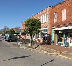 Hillsboro Street in downtown Pittsboro | |
| Nickname(s): Circle City | |
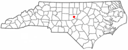 Location of Pittsboro, North Carolina | |
| Coordinates: 35°43′13″N 79°10′35″W / 35.72028°N 79.17639°WCoordinates: 35°43′13″N 79°10′35″W / 35.72028°N 79.17639°W | |
| Country | United States |
| State | North Carolina |
| County | Chatham |
| Area | |
| • Total | 4.2 sq mi (10.8 km2) |
| • Land | 4.1 sq mi (10.7 km2) |
| • Water | 0.04 sq mi (0.1 km2) |
| Elevation | 394 ft (120 m) |
| Population (2010) | |
| • Total | 3,743 |
| • Estimate (2016)[1] | 4,266 |
| • Density | 900/sq mi (350/km2) |
| Time zone | UTC-5 (Eastern (EST)) |
| • Summer (DST) | UTC-4 (EDT) |
| ZIP codes | 27228, 27312 |
| Area code(s) | 919 |
| FIPS code | 37-52660[2] |
| GNIS feature ID | 1021992[3] |
| Website |
pittsboronc |
Pittsboro is a town in Chatham County, North Carolina, United States. The population was 3,743 at the 2010 census.[4] It is the county seat of Chatham County.[5]
History
Pittsboro was established as a town in 1785. The Chatham County Court House was built on land belonging to Mial Scurlock; however, in 1787, the legislature declared that a town could not be established on Scurlock's land. The town's trustees instead purchased adjacent land belonging to William Petty and laid out the town. That same year, Pittsboro was officially named the county seat. Although Chatham County is named for William Pitt, 1st Earl of Chatham, Pittsboro is named for his son, William Pitt the Younger.
Pittsboro was once considered as a potential site for both the University of North Carolina and the state capital. The university was established in Chapel Hill, beginning in 1789. The state capital was located in Raleigh, 34 miles (55 km) to the east of Pittsboro.
As the county seat, Pittsboro has been a center of trade and local government, including the courts. Many farmers would come into town on the weekend for trade. The area did not have large plantations, but farmers also depended on slave labor. In 1860, nearly one-third of the county population was made up of enslaved African Americans. After the Civil War and emancipation, whites used violence and other means to enforce white supremacy and suppress the freedmen's Republican vote. The Ku Klux Klan and other vigilante groups were active in the county.[6] Violence continued during the stress of economic hard times at the end of the century and into the early 20th century, when the state disenfranchised most blacks. This political exclusion lasted until after 1965 and passage of the Voting Rights Act.
In 1881, a new county courthouse and jail were built in Pittsboro. During the previous decade, textile mills in the north central area of the county provided new manufacturing jobs to white workers who had lost farmholdings due to economic depressions during the 1870s and early 1880s. It was the beginning of industrialization in this area.
In 1885, Pittsboro was the scene of a notorious mass lynching of four African Americans, including a woman, that earned statewide condemnation. They were tenant farmers. A masked mob took Jerry Finch, his wife Harriet, and Lee Tyson from jail, where they were being held after arrest as suspects in a robbery/murder case.[6] Harriet Finch was one of four black women to be lynched in the state.[7] They also took and hanged John Pattishall, who was awaiting trial for two other unrelated robbery/murders.[8]
Local currency: the PLENTY
In 2002 some citizens of Pittsboro revitalized a local form of currency called the PLENTY. In 2009, it was being exchanged at a local bank at the rate of $9 for every $10 of PLENTY. The currency failed to gain traction during both releases and is no longer used.
Chatham County Courthouse fire
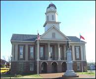
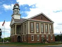
On March 25, 2010, the Chatham County Courthouse (pictured above), while undergoing a $415,000 exterior renovation, caught fire. Smoke was first reported in the area around 4:15 p.m.; the fire was dispatched to the Pittsboro Fire Department around 4:45 p.m. By 5 p.m., smoke was reported to be rising from out of the clock tower, which was surrounded by scaffolds. The building was evacuated safely.
The building suffered severe damage to the clock tower and the third floor. It was reported that the fire had destroyed all the computers and records, but there are offsite copies and the information should be recoverable.[9]
On March 26, 2010, at approximately 1:30 a.m., the clock tower collapsed onto the main building, but the building as whole was damaged only on the second floor. Damage in the rest of the building was from water and smoke effects. Overall 11 fire departments participated in the fire efforts.
The fire marshal's investigation into the fire determined that it was caused by a soldering torch that ignited wood near the soffit. Workers attempted to extinguish the blaze, but were unsuccessful. On Wednesday, March 31, 2010, the Chatham County Commissioners voted in favor of rebuilding the courthouse.[10] The courthouse officially reopened on April 20, 2013.[11]
City government
The mayor of Pittsboro is elected at-large. The current one is Cindy S. Perry. The town's five members of the Board of Commissioners are elected from single-member districts. They are Pamela Baldwin, J.A. (Jay) Farrell, Bett Wilson Foley, John Bonitz, and Michael A. Fiocco. The Board of Commissioners hires a town manager to administer daily operations of the city; the current one is Bryan Gruesbeck.
Pittsboro Police is directed by Chief Percy Crutchfield. Serving the 3000 residents of Pittsboro, the department consists of 8 patrolmen, 1 community police officer, 1 lead investigator and 1 lieutenant.[12]
Educational facilities
The town is served by four local schools and a Central Carolina Community College campus:
- Pittsboro Elementary School
- Horton Middle School
- Margaret B. Pollard Middle School
- Northwood High School
- Central Carolina Community College (CCCC), Chatham County Campus
Media outlets
- Newspapers
- Network television
- County Resource for Life in Chatham
Geography
Pittsboro is located east of the center of Chatham County at 35°43′13″N 79°10′35″W / 35.72028°N 79.17639°W (35.720332, -79.176393).[13]
According to the United States Census Bureau, the town has a total area of 4.2 square miles (10.8 km2), of which 4.1 square miles (10.7 km2) is land and 0.04 square miles (0.1 km2), or 0.86%, is water.[4]
U.S. Highways 15 and 501 run concurrently through the center of the town as Hillsboro Street and Sanford Road, leading north 17 miles (27 km) to the center of Chapel Hill and the University of North Carolina, and south 17 miles (27 km) to Sanford. U.S. Route 64 bypasses Pittsboro to the north and leads east 34 miles (55 km) to Raleigh and west 16 miles (26 km) to Siler City. U.S. Route 64 Business passes through the town as West Street and East Street, crossing US 15/501 at the traffic circle that surrounds the historic Chatham County Courthouse in the center of town. North Carolina Highway 87 leads northwest from Pittsboro 32 miles (51 km) to Burlington.
Near the geographic center of the state, Pittsboro is 150 miles (240 km) from Wilmington at the coast and the same from Boone in the Blue Ridge Mountains.
Jordan Lake is 8 miles (13 km) east, providing recreation, fishing, boating and scenic panoramas. The lake is 14,000 acres (5,700 ha) of surface and provides water for Raleigh and the town of Cary.
Demographics
| Historical population | |||
|---|---|---|---|
| Census | Pop. | %± | |
| 1900 | 424 | — | |
| 1910 | 502 | 18.4% | |
| 1920 | 584 | 16.3% | |
| 1930 | 675 | 15.6% | |
| 1940 | 826 | 22.4% | |
| 1950 | 1,094 | 32.4% | |
| 1960 | 1,215 | 11.1% | |
| 1970 | 1,447 | 19.1% | |
| 1980 | 1,332 | −7.9% | |
| 1990 | 1,436 | 7.8% | |
| 2000 | 2,226 | 55.0% | |
| 2010 | 3,743 | 68.1% | |
| Est. 2016 | 4,266 | [1] | 14.0% |
| U.S. Decennial Census[14] | |||
2010 Census The Census of 2010 shows a population of 3,743, 68% growth since 2000. The racial makeup of the town was: 72% White, 19% African American, 4% some other race alone, 2% two or more races. Almost 9% of the population was Hispanic or Latino. 54% of the population is female and 46% male.
2000 Census As of the census[2] of 2000, there were 2,226 people, 855 households, and 535 families residing in the town. The population density was 663.1 people per square mile (255.8/km²). There were 939 housing units at an average density of 279.7 per square mile (107.9/km²). The racial makeup of the town was 64.38 percent White, 27.54 percent African American, 0.49 percent Native American, 0.67 percent Asian, 0.04 percent Pacific Islander, 4.99 percent from other races, and 1.89 percent from two or more races. Hispanic or Latino of any race were 8.81 percent of the population.
There were 855 households out of which 29.0 percent had children under the age of 18 living with them, 40.9 percent were married couples living together, 18.7 percent had a female householder with no husband present, and 37.4 percent were non-families. 32.3 percent of all households were made up of individuals and 12.7 percent had someone living alone who was 65 years of age or older. The average household size was 2.34 and the average family size was 2.97.
In the town, the population was spread out with 22.9% under the age of 18, 7.3 percent from 18 to 24, 28.7 percent from 25 to 44, 19.6 percent from 45 to 64, and 21.5 percent who were 65 years of age or older. The median age was 39 years. For every 100 females, there were 80.7 males. For every 100 females age 18 and over, there were 75.0 males.
The median income for a household in the town was $35,800, and the median income for a family was $42,391. Males had a median income of $29,500 versus $26,719 for females. The per capita income for the town was $16,863. About 19.2 percent of families and 18.3 percent of the population were below the poverty line, including 24.3 percent of those under age 18 and 13.7 percent of those age 65 or over.
Economy
Once home to textiles, the largest clothing label mill in the world, and poultry, the town now depends on commuter income, retail stores and a developing business in genetics. Housing developments provide relief from loss of industry as the town adjusts to a new economy.
The water supply is abundant, derived from the Haw River. In the future, Jordan Lake will provide much of the water supply. In 2010, the wastewater allotment was expanded. The town is 15 miles (24 km) and 25 miles (40 km) from major power plants. Major corridor highways, US 15-501 and US 64, a four-lane divided highway, intersect there.
Pittsboro is home to the Chatham County Government, the Chatham County Justice Center, and many non-profit agencies and other social service organizations. Pittsboro is also a Certified Retirement Community.
National Register of Historic Places listings
- Alston-DeGraffenried House
- Aspen Hall
- Baldwin's Mill
- Sheriff Stephen Wiley Brewer Farmstead
- Chatham County Courthouse
- Luther Clegg House
- Lewis Freeman House
- Hadley House and Grist Mill
- Hall-London House
- Kelvin
- London Cottage
- Henry Adolphus London House
- McClenahan House
- Moore-Manning House
- Pittsboro Historic District
- Pittsboro Masonic Lodge
- Pittsboro Presbyterian Church
- Reid House
- Patrick St. Lawrence House
- A. P. Terry House
- James A. Thomas Farm[15]
Notable people
- William Joseph Franks (1830-1880), United States Navy sailor who received the Medal of Honor for his actions in the American Civil War
- Anne Taylor Nash (1884-1968), painter[16]
- Tobais Palmer (b. 1990), football wide receiver
- Charles M. Stedman (1841-1930), the last Civil War veteran to serve in Congress
- James Iredell Waddell (1824-1886), officer in the United States Navy and later in the Confederate States Navy
- Ursula Vernon (b. 1977), children's author, artist
See also
References
- 1 2 "Population and Housing Unit Estimates". Retrieved June 9, 2017.
- 1 2 "American FactFinder". United States Census Bureau. Retrieved 2008-01-31.
- ↑ "US Board on Geographic Names". United States Geological Survey. 2007-10-25. Retrieved 2008-01-31.
- 1 2 "Geographic Identifiers: 2010 Demographic Profile Data (G001): Pittsboro town, North Carolina". U.S. Census Bureau, American Factfinder. Retrieved December 29, 2014.
- ↑ "Find a County". National Association of Counties. Archived from the original on May 31, 2011. Retrieved 2011-06-07.
- 1 2 Patrick J. Huber, "Caught Up in the Violent Whirlwind of Lynching": The 1885 Quadruple Lynching in Chatham County, North Carolina, The North Carolina Historical Review, Vol. 75, No. 2 (APRIL 1998), pp. 135-160; via JSTOR; accessed 09 June 2018
- ↑ Bruce E. Baker, "Lynching", 2006, Encyclopedia of North Carolina, ed. by William S. Powell; accessed 09 June 2018
- ↑ Sarah Burke, "Without Due Process: Lynching in North Carolina 1880-1900", Explorations, n.d., University of North Carolina Wilmington; accessed 09 June 2018
- ↑ WRAL (25 March 2010). "Fire severely damages Chatham County courthouse :: WRAL.com". Retrieved 31 January 2017.
- ↑ WRAL (31 March 2010). "Chatham commissioners vote to rebuild courthouse :: WRAL.com". Retrieved 31 January 2017.
- ↑ http://www.newsobserver.com/2013/04/20/2839308/historic-chatham-county-courthouse.html
- ↑ "Police Department - Pittsboro, NC". Retrieved 31 January 2017.
- ↑ "US Gazetteer files: 2010, 2000, and 1990". United States Census Bureau. 2011-02-12. Retrieved 2011-04-23.
- ↑ "Census of Population and Housing". Census.gov. Archived from the original on May 12, 2015. Retrieved June 4, 2015.
- ↑ National Park Service (2010-07-09). "National Register Information System". National Register of Historic Places. National Park Service.
- ↑ A Southern Collection. University of Georgia Press. 1 February 1993. pp. 150–. ISBN 978-0-8203-1535-5.
Further reading
- Larry C. Thomas, The Double Axe Murder of the Gunter's and Finch's Family of Chatham County, North Carolina, Sanford, NC: The Author, 1990
External links
| Wikimedia Commons has media related to Pittsboro, North Carolina. |
| Wikivoyage has a travel guide for Pittsboro. |
- Town of Pittsboro official website
- Chatham County Economic Development Corporation
- Haw River Assembly, local conservation organization
- Chatham County Events, Community Website for all events, parks, and businesses in Chatham County
Municipalities and communities of Chatham County, North Carolina, United States | ||
|---|---|---|
| Towns |  | |
| CDPs | ||
| Unincorporated communities | ||
| Footnotes | ‡This populated place also has portions in an adjacent county or counties | |
Greater Durham-Chapel Hill Metropolitan Region (Durham MSA, part of the Research Triangle) | ||
|---|---|---|
| Principal cities |  | |
| Other significant cities | ||
| Counties | ||
| Major universities | ||
| Transportation | ||
| Newspapers | ||
| Miscellaneous | ||