Luigny
| Luigny | ||
|---|---|---|
| Commune | ||
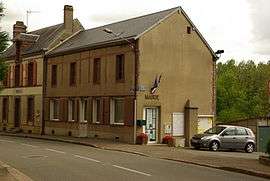 Town hall | ||
| ||
 Luigny Location within Centre-Val de Loire region  Luigny | ||
| Coordinates: 48°14′30″N 1°01′27″E / 48.2417°N 1.0242°ECoordinates: 48°14′30″N 1°01′27″E / 48.2417°N 1.0242°E | ||
| Country | France | |
| Region | Centre-Val de Loire | |
| Department | Eure-et-Loir | |
| Arrondissement | Nogent-le-Rotrou | |
| Canton | Brou | |
| Intercommunality | Perche-Gouët | |
| Government | ||
| • Mayor (2008–2014) | Michel Ricoul | |
| Area1 | 15.88 km2 (6.13 sq mi) | |
| Population (2008)2 | 407 | |
| • Density | 26/km2 (66/sq mi) | |
| Time zone | UTC+1 (CET) | |
| • Summer (DST) | UTC+2 (CEST) | |
| INSEE/Postal code | 28219 /28480 | |
| Elevation |
173–257 m (568–843 ft) (avg. 190 m or 620 ft) | |
|
1 French Land Register data, which excludes lakes, ponds, glaciers > 1 km2 (0.386 sq mi or 247 acres) and river estuaries. 2 Population without double counting: residents of multiple communes (e.g., students and military personnel) only counted once. | ||

Luigny is a commune in the Eure-et-Loir department in northern France.
Population
| Historical population | ||
|---|---|---|
| Year | Pop. | ±% |
| 1962 | 415 | — |
| 1968 | 446 | +7.5% |
| 1975 | 441 | −1.1% |
| 1982 | 347 | −21.3% |
| 1990 | 342 | −1.4% |
| 1999 | 376 | +9.9% |
| 2008 | 407 | +8.2% |
See also
References
| Wikimedia Commons has media related to Luigny. |
This article is issued from
Wikipedia.
The text is licensed under Creative Commons - Attribution - Sharealike.
Additional terms may apply for the media files.