Perche
| Perche (Le Perche) | ||
|---|---|---|
| Region | ||
| ||
| Country |
| |
| Prefecture | Belleme, Mortagne-au-Perche, Nogent-le-Rotrou | |
| Demonym(s) | Percheron | |
| Time zone | UTC+1 (CET) | |
| • Summer (DST) | UTC+2 (CEST) | |
.svg.png)

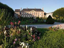
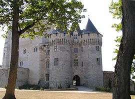
Perche (French pronunciation: [pɛʁʃ]) (French: le Perche) is a former province or county of northwestern France, best known for its forests and its Percheron draft horse. It was primarily located within the present-day departments of Orne and Eure-et-Loir, with small parts now in the neighboring departments of Eure, Loir-et-Cher and Sarthe.[1][2]
Geography

Before the French Revolution, Perche was bounded by the following ancient provinces: Normandy to the north and west, Maine to the west, Beauce and Orléanais to the east and south.
The greater part of the district is nowadays occupied by a semicircle of heights (from 650 to 1000 ft. in height), known as les collines du Perche (the Hills of Perche), stretching from Moulins-la-Marche on the northwest to Montmirail on the south; within the basin formed thereby the shape of which is defined by the Huisne, an effluent of the Sarthe, lie the chief towns of Mortagne-au-Perche, Nogent-le-Rotrou and Bellême.[1]
Perche's principal towns
The following table lists the principal towns in Perche province along with the distance of any given town to Condé-sur-Huisne, situated near the Perche's geographic center:
| km | km | km | km | km | |||||
| Arrou | 48 | Ceton | 23 | La Ferté-Vidame | 29 | Luigny | 31 | Senonches | 29 |
| Authon-du-Perche | 29 | Chateauneuf-en-Thymerais | 40 | La Loupe | 18 | Montmirail | 41 | Tourouvre | 34 |
| Belleme | 27 | Condé-sur-Huisne | ~0 | Le Gault-du-Perche | 43 | Mortagne-au-Perche | 31 | Verneuil-sur-Avre | 44 |
| Brezolles | 45 | Digny | 32 | Longny-au-Perche | 22 | Nogent-le-Rotrou | 8 | ||
Peripheral towns
Nearby towns in the four ancient provinces along the periphery of Perche province include (starting from the north, clockwise): L'Aigle, Dreux, Chartres, Châteaudun, Le Mans, Mamers, Alençon and Sées.
Economy
Agriculture and tourism constitute the economic focus of Perche's natural region, the largest parts of which are located within the departments of Orne and Eure-et-Loir, in the regions of Normandy and Centre-Val de Loire, respectively.[1]
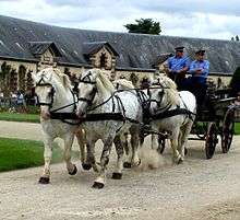
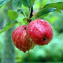
The Percheron breed of draft horses originated in Perche's Huisne river valley and is identified throughout the world as the Perche's most well known symbol. Apples (for hard cider) and pears are grown throughout the district.
Etymology
"Perche" appeared first in Latin as Saltus Particus andSilva Pertica or Sylva Pertica[3] (both meaning "Perche Forest"). The root word may come from Latin FR:Pertica, a measuring unit of ten Roman feet or decempeda, which survives in modern French as FR:Perche (unité) (English equivalent, Rod (unit). In early Frankish times appeared the terms Pagus Pertensis (6th Century) and Pagus Perticus (undated).[4]
History
Pre-history
Perche's prehistory is manifested by megaliths (dolmens, menhirs) and prehistoric tools of flint, bronze, and iron.[5]
Middle Ages
See also Lords, counts and dukes of Perche
Perche was essentially a region between other regions:
". . . the Perche was not based on an existing administratative unit, such as its neighbors, the counties of Maine and Chartres, nor was it coterminous with an ecclesiastical jurisdiction. It grew up at the margins of several larger units, and there was no major population focus nor great religious centre such as a cathedral or ancient abbey within it. It owed its existence to the ambition and energy of successive members of a lineage of warrior elite."[2]
In the Middle Ages, the Count of Perche (Comté du Perche) governed the region between Normandy and Maine. It was held by an independent line of counts. By the 12th Century, two large families contended for control of the Perche region: the Talvas of Bellême and the Rotrou of Nogent-le-Rotrou. In 1114, Rotrou III annexed Bellême. In 1226, Count Geoffroy V would have been a leader of the Fourth Crusade had he not died before its departure to the Near East. This end of the Rotrou dynasty led to the region's annexation to the Crown of France (by inheritance). At this time, the Crown divided part of the region to create the county of Alençon. After 1325, both counties were generally held by a member or members of a cadet branch of the House of Valois. During the Hundred Years War, partisans of England plundered Perche, destroyed its nobility, and burned many castles and abbeys. In 1449, free from English domination, Perche began reconstruction. Upon the death of Alençon's last duke (1525), rule returned to and remained under to the French crown, and was granted only sporadically thereafter.[1][2][5]
Modern Times
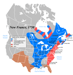
In the three decades starting in 1632, a large proportion of immigrants to New France came from Perche, in what has been called the Percheron immigration movement.[6] Many Percherons were thus recruited to work in seigneuries being establishing along the Saint Lawrence valley. The Beauport seigneurie, New France's first agricultural-oriented seigneurie, was granted in 1634 to Robert Giffard de Moncel by the Company of Hundred Associates. While the total number of emigrants was small, Perche had a much higher rate of emigration to New France than most other regions of France. Nearly all French Canadians have some ancestors from the villages of Perche.[5]Prominent last names from Perche who came to Canada starting just before the end of Samuel de Champlain's tenure include: Côté, Boucher, Cloutier, Guyon (Dion), Tremblay and Paradis.[7]
After the French Revolution, Perche was divided into four departments: Orne, Eure-et-Loir, Sarthe, and Loir-et-Cher. At this time, national law replaced FR:coûtume du Perche or local, customary law.[5]
In 1998, the government of France created the Perche Regional Nature Park (Parc naturel régional du Perche – see FR:Perche (région naturelle)).[8] The Parc is full of oaks, beeches, and ashes; wild board, black woodpeckers, red squirrels, and roe deer.[3][5]
See also
References
- 1 2 3 4 "Perche". Encyclopædia Britannica. Encyclopædia Britannica, Inc. 2 May 2011. Retrieved 21 March 2018.
- 1 2 3 Thompson, Kathleen (2002). Power and Border Lordship in Medieval France: The County of the Perche, 1000-1226. Boydell & Brewer. pp. 5, 9 ("the Perche" and modern equivalent), 11 (margins, formation), 13. Retrieved 21 March 2018.
- 1 2 "The true nature of Perche". Parc naturel régional du Perche. Retrieved 21 March 2018.
- ↑ Ernest Nègre, Toponymie générale de la France, Volume I, librairie Droz, 1990.
- 1 2 3 4 5 "Un peu d'Histoire… (A Short History...)". Le Tour des Collines du Perche (Tour of the Hills of Perche). Retrieved 18 March 2018.
- ↑ perche-canada.net. "Association Perche-Canada History".
- ↑ Larson, Denise R. (2008). Companions of Champlain: Founding Families of Quebec, 1608-1635. Genealogical Publishing. Retrieved 21 March 2018.
- ↑ "A natural park for the Perche". Parc naturel régional du Perche. Retrieved 21 March 2018.
External links
- Parc naturel régional du Perche
- Vermont French-Canadian Genealogical Society: Le Perche
- perche-quebec.com
- Rossant, Colette (25 March 2007). "France's Le Perche Is the Last Terroir". New York Times. Retrieved 21 March 2018. </ref>
Coordinates: 48°22′N 0°49′E / 48.36°N 0.81°E
