Brou, Eure-et-Loir
| Brou | ||
|---|---|---|
| Commune | ||
 | ||
| ||
 Brou Location within Centre-Val de Loire region  Brou | ||
| Coordinates: 48°12′39″N 1°10′05″E / 48.2108°N 1.1681°ECoordinates: 48°12′39″N 1°10′05″E / 48.2108°N 1.1681°E | ||
| Country | France | |
| Region | Centre-Val de Loire | |
| Department | Eure-et-Loir | |
| Arrondissement | Châteaudun | |
| Canton | Brou | |
| Intercommunality | Perche-Gouët | |
| Government | ||
| • Mayor (2008–2014) | Philippe Masson | |
| Area1 | 19.83 km2 (7.66 sq mi) | |
| Population (2008)2 | 3,534 | |
| • Density | 180/km2 (460/sq mi) | |
| Time zone | UTC+1 (CET) | |
| • Summer (DST) | UTC+2 (CEST) | |
| INSEE/Postal code | 28061 /28160 | |
| Elevation | 147–201 m (482–659 ft) | |
|
1 French Land Register data, which excludes lakes, ponds, glaciers > 1 km2 (0.386 sq mi or 247 acres) and river estuaries. 2 Population without double counting: residents of multiple communes (e.g., students and military personnel) only counted once. | ||
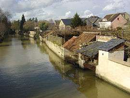
Brou is a commune in the Eure-et-Loir department in northern France.
Population
| Historical population | ||
|---|---|---|
| Year | Pop. | ±% |
| 1962 | 3,270 | — |
| 1968 | 3,501 | +7.1% |
| 1975 | 3,614 | +3.2% |
| 1982 | 3,825 | +5.8% |
| 1990 | 3,803 | −0.6% |
| 1999 | 3,713 | −2.4% |
| 2008 | 3,583 | −3.5% |
See also
References
External links
| Wikimedia Commons has media related to Brou. |
- Official site
- Félix Charpentier. Sculptor of Brou War Memorial
This article is issued from
Wikipedia.
The text is licensed under Creative Commons - Attribution - Sharealike.
Additional terms may apply for the media files.