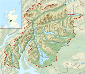
Loch Lomond and The Trossachs National Park
| Loch Lomond and The Trossachs National Park | |
|---|---|
|
IUCN category V (protected landscape/seascape) | |
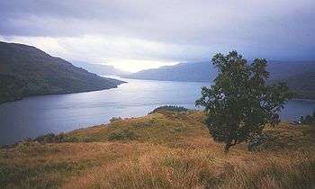 Looking eastwards along Loch Katrine | |
 | |
| Location | Scotland, Argyll and Bute, Cowal, Perth and Kinross, Stirling and West Dunbartonshire |
| Coordinates | 56°15′N 4°37′W / 56.250°N 4.617°WCoordinates: 56°15′N 4°37′W / 56.250°N 4.617°W |
| Area | 1,865 km2 (720 sq mi) |
| Established | 2002 |
| Governing body | National park authority |
Loch Lomond and The Trossachs National Park (Scottish Gaelic: Pàirc Nàiseanta Loch Laomainn is nan Tròisichean) is a national park in Scotland centred on Loch Lomond, and includes several ranges of hills and the Trossachs. It was the first of the two national parks established by the Scottish Parliament in 2002,[1] the second being the Cairngorms National Park.
The park is the fourth largest in the British Isles, with a total area of 1,865 km2 (720 sq mi) and a boundary of some 350 km (220 mi) in length. It includes 21 Munros (including Ben Lomond, Ben Lui, Beinn Challuim, Ben More and two peaks called Ben Vorlich), 19 Corbetts, two forest parks (Queen Elizabeth and Argyll) and 57 designated special nature conservation sites. There are two National Nature Reserves within the National Park: Loch Lomond National Nature Reserve and The Great Trossachs Forest National Nature Reserve. The former is managed by Scottish Natural Heritage (SNH), and the latter by a partnership of the Forestry Commission Scotland, the Royal Society for the Protection of Birds and the Woodland Trust (Scotland).
15,600 people live in the park, which is customarily split into four sections: Breadalbane, Loch Lomond, The Trossachs, and Argyll Forest Park.
Sights
The park consists of many mountains and lochs, and the principal attractions are scenery, walking, and wildlife.[2]
For walkers seeking a challenge, the West Highland Way passes through the park, while the mountains of Ben Lomond in Dunbartonshire and The Cobbler in the Arrochar Alps on the Cowal Peninsula attract most hikers. Less intrepid visitors can detour from the A82 to view the Falls of Dochart.
There is a national park visitor centre at the southern end of Loch Lomond, called Loch Lomond Shores in Balloch, which includes a visitor information centre at the most popular gateway to the park, as well as an aquarium, shops and restaurants.
On Loch Katrine, visitors can travel on the historic steamship SS Sir Walter Scott, while cruises on Loch Lomond can be taken from Tarbet, Argyll and Bute and Balloch; there is also an extensive water taxi service between most lochside communities.
Towns and villages within the park
| Council area | Towns and villages |
|---|---|
| Stirling | Aberfoyle, Balmaha, Brig o' Turk, Callander, Crianlarich, Croftamie, Drymen, Inversnaid, Killin, Lochearnhead, Port of Menteith, Tyndrum, Strathyre, Balquhidder, Kilmahog, Gartmore, Inchmahome (Island of Lake of Menteith) |
| West Dunbartonshire | Balloch, Croftamie, Gartocharn |
| Perth and Kinross | St Fillans |
| Argyll and Bute | Ardentinny, Ardlui, Arrochar, Blairmore, Carrick Castle (village), Glenbranter, Kilmun, Lochgoilhead, Luss, Tarbet, Succoth, Strone, Whistlefield. |
Munros within the Park
A list of mountains over 3,000 feet (914 m) within the park and the closest village:
- Ben More (1,174 m, 3,852 ft), Crianlarich
- Stob Binnein (1,165 m, 3,822 ft), Crianlarich
- Ben Lui (1,130 m, 3,707 ft), Tyndrum
- Cruach Ardrain (1,046 m, 3,432 ft), Crianlarich
- Ben Oss (1,029 m, 3,376 ft), Tyndrum
- Ben Challum (1,025 m, 3,363 ft), Tyndrum
- Beinn Ime (1,011 m, 3,317 ft), Arrochar
- An Caisteal (995 m, 3,264 ft), Crianlarich
- Ben Vorlich (985 m, 3,232 ft), Lochearnhead
- Beinn Dubhchraig (978 m, 3,209 ft), Tyndrum
- Stuc a' Chroin (975 m, 3,199 ft), Lochearnhead
- Ben Lomond (974 m, 3,196 ft), Balmaha
- Meall Glas (959 m, 3,146 ft), Crianlarich
- Beinn Tulaichean (945 m, 3,100 ft), Crianlarich
- Ben Vorlich (943 m, 3,094 ft), Ardlui
- Beinn a' Chroin (940 m, 3,084 ft), Crianlarich
- Beinn Chabhair (933 m, 3,061 ft), Ardlui
- Beinn Narnain (926 m, 3,038 ft), Arrochar
- Sgiath Chuil (921 m, 3,022 ft), Crianlarich
- Beinn a' Chleibh (916 m, 3,005 ft), Tyndrum
- Ben Vane (915 m, 3,002 ft), Ardlui
There are 21 Munros in the National Park and 16 of them are within Breadalbane. Ben Lomond remains the most popular mountain in Scotland to be climbed.
See also
References
External links
| Wikivoyage has a travel guide for Loch Lomond and The Trossachs National Park. |
| Wikimedia Commons has media related to Loch Lomond and The Trossachs National Park. |
- Loch Lomond and The Trossachs National Park Official Website
- Argyll Forest Park at forestry.gov.uk
| Authority control |
|---|