Loch Leven (Kinross)
| Loch Leven | |
|---|---|
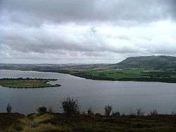 Looking north from Vane Farm | |
 Loch Leven | |
| Coordinates | 56°12′01″N 3°22′47″W / 56.20019°N 3.37963°WCoordinates: 56°12′01″N 3°22′47″W / 56.20019°N 3.37963°W |
| Type | freshwater loch |
| Max. length | 5.24 km (3.26 mi)[1] |
| Max. width | 4.18 km (2.60 mi)[1] |
| Surface area | 1,611 ha (3,980 acres)[2] |
| Average depth | 15 ft (4.6 m)[1] |
| Max. depth | 44 ft (13 m)[1] |
| Shore length1 | 23 km (14 mi) [2] |
| Surface elevation | 106 m (348 ft)[2] |
| Islands | Loch Leven Castle, St Serf's Island, Reed Bower, Alice's Bower, Scart Island |
| Official name | Loch Leven |
| Designated | 5 January 1976 |
| Reference no. | 72[3] |
| 1 Shore length is not a well-defined measure. | |
Loch Leven (from Scottish Gaelic: Loch Lìobhann) is a fresh water loch located immediately to the east of Kinross in Perth and Kinross council area, central Scotland.[1] [2] Roughly triangular, the loch is about 6km at its longest. The burgh of Kinross lies at its western end. Loch Leven Castle lies on an island a short way offshore, where Mary, Queen of Scots was imprisoned in 1567, and it can be reached by ferry, operated from Kinross by Historic Scotland during the summer months. Prior to the canalisation of the River Leven, and the partial draining of the Loch in 1826-36, Loch Leven was considerably larger. The drop in water level by 1.4metres, reduced to the loch to 75% of its former size, and exposed several small islands, and greatly increasing the size of the existing ones.[4] It is thought that the loch is possibly the site of an impact crater formed 270 Million years ago.[5]
Relics
Several relics were found during the draining, one of them being a sceptre, "apparently of cane, hilted with ivory, and mounted with silver, upon which … were the letters of the words, "Mary, Queen of Scots"," found near the Mary Knowe, where she is supposed to have landed after her escape from the castle.[6]
Islands
St Serf's Inch is the largest of Loch Leven's seven islands and it was the home of a Culdee and then an Augustinian monastic community, St Serf's Inch Priory. There was a monastic community on the island which was old in the 12th century. The monastery produced a series of Gaelic language charters from the 11th and 12th centuries which were translated into Latin in the late 12th century.
There is an all abilities path around the loch, known as the Loch Leven Heritage Trail, which can be accessed from seven different car parks around the loch at Kinross Pier; Kirkgate Park; Burleigh Sands; Loch Leven's Larder; Findatie; RSPB Loch Leven car park; and the car park at the Cashmere Factory.
Loch Leven National Nature Reserve
Loch Leven forms the main part of the Loch Leven National Nature Reserve (NNR), which covers 1925 hectares, including 1300 hectares of loch and islands. The NNR is managed in partnership by a number of groups. The majority of the land and water within Loch Leven NNR is managed by Scottish Natural Heritage (SNH), with the wetlands on the southern shore managed by the Royal Society for the Protection of Birds (RSPB) and the fishing and shooting managed by Kinross Estate. Additionally, Castle Island is managed by Historic Scotland, who also run the ferry to the island.
Loch Leven was first declared a National Nature Reserve in 1964 and re-declared in 2002, when it was extended to include the RSPB Loch Leven section. As the largest lowland loch in Scotland, it is an important site for waterfowl, with up to 35,000 birds present in the winter months.[7] These birds migrate to Loch Leven from a variety of places, such as Greenland, Iceland, Ireland, Siberia and northern and central Europe.[8] Detailed information on the wildlife at Loch Leven can be found in SNH's publication, The Story of Loch Leven National Nature Reserve.
Designations
Loch Leven is an internationally important site for wildlife and as such, has a number of designations:
- Loch Leven Site of Special Scientific Interest (SSSI);
- Loch Leven Special Protection Area (SPA);
- Loch Leven RAMSAR site;
- Loch Leven National Nature Reserve (NNR);
- Scheduled Monuments: Loch Leven Castle and St Serf's Priory
Gallery
 View east across Loch Leven from Kinross
 Satellite photograph of Loch Leven and the surrounding area
References
- 1 2 3 4 5 John, Murray; Lawrence, Pullar (1910). Bathymetrical Survey of the Fresh-Water Lochs of Scotland, 1897-1909 Lochs of the Forth Basin Volume II - Loch Leven. National Library of Scotland: National Challenger Officer. p. 20. Retrieved 12 May 2018.

- 1 2 3 4 "Loch Leven". British Lakes. Retrieved 12 May 2018.
- ↑ "Loch Leven". Ramsar Sites Information Service. Retrieved 25 April 2018.
- ↑ "Loch Leven". The Gazetteer for Scotland. School of GeoSciences, University of Edinburgh and The Royal Scottish Geographical Society. Retrieved 13 May 2018.
- ↑ B. J. Hamill (2003). The Loch Leven Crater: Anatomy Of A Low-Angle Oblique Impact Structure, Large Meteorite Impacts (2003)
- ↑ "Ancient Relics". Bell's Weekly Messenger. April 3, 1831. Retrieved 2009-07-10.
- ↑ http://www.snh.gov.uk/docs/A1884530.pdf
- ↑ http://www.snh.gov.uk/docs/A1884530.pdf
External links
| Wikimedia Commons has media related to Loch Leven. |