Ariundle Oakwood National Nature Reserve
| Ariundle Oakwood National Nature Reserve | |
|---|---|
|
IUCN category IV (habitat/species management area) | |
 Ariundle Oakwood | |
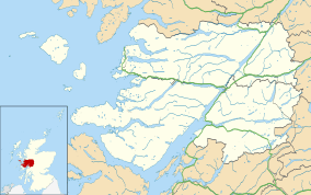 | |
| Location | Strontian, Lochaber, Scotland |
| Coordinates | 56°42′59″N 5°32′34″W / 56.7164°N 5.5428°WCoordinates: 56°42′59″N 5°32′34″W / 56.7164°N 5.5428°W |
| Area | 70 ha[1] |
| Established | 1977[2] |
| Governing body | Scottish Natural Heritage (SNH) |
| Ariundle Oakwood National Nature Reserve | |
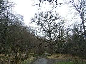
Ariundle Oakwood, (Scottish Gaelic: Airigh Fhionndail,[3] "the shieling of the white meadow") is a part of the ancient Sunart Oakwood and is situated between the village of Strontian and the former lead mine sites. It was designated a National Nature Reserve in 1977 and is managed primarily by Scottish Natural Heritage, as well as the Forestry Commission for Scotland.[2] The wood is a remnant of ancient oakwood that once spanned the Atlantic coasts of Europe from Norway to Portugal.[4] It is a temperate rainforest, with sessile oak being the dominant tree species. Other native species including holly, hazel, birch, rowan, willow, ash and wych elm are also present.[5]
The wood contains remains from earlier settlements in the Strontian area, including charcoal platforms, pony tracks, enclosure dykes, potato lazy beds, and old coppice trees. The people there were described as sluagh an torraidh bhain, or the people of the white hillock, with the settlement recorded as "Torban" in Clan Cameron records. Torban was abandoned to sheep farming in the early 19th century.[6] From 1752, the wood was a source of charcoal for the Bonawe iron furnace on Loch Etive and locally in the lead mining industry. The oak trees were coppiced to ensure a steady of wood for the furnaces, and many of the mature oak trees are multi-stemmed as a result of this practice.[5] Managing the woodland brought about a thousand workers to the area. Lead mining fell off in the early 19th Century and the Bonawe Furnace closed in 1876. After this the woods were no longer needed to supply fuel, but were used as a sheltered area for livestock.[7]
In 1961, Ariundle Wood was designated a Forest Nature Reserve,[8] before its designation as a National Nature Reserve in 1977. The reserve is classified as a Category IV protected area by the International Union for Conservation of Nature.[9]
The main path through the nature reserve is the start of the most accessible route to Sgùrr Dhòmhnuill, a Corbett and the 17th highest relative peak in Britain.
References
Citations
- ↑ "Site Details for Ariundle Oakwood". Scottish Natural Heritage. 2018-03-05. Retrieved 2018-03-28.
- 1 2 The Story of Ariundle Oakwood National Nature Reserve. p. 14.
- ↑ "Ariundle". Ainmean-Àite na h-Alba. Retrieved 2018-10-11.
- ↑ The Story of Ariundle Oakwood National Nature Reserve. p. 4.
- 1 2 The Story of Ariundle Oakwood National Nature Reserve. p. 5.
- ↑ "Ariundle Oakwoods". Retrieved 2013-01-29.
- ↑ The Story of Ariundle Oakwood National Nature Reserve. p.p. 11-12.
- ↑ "Scotland's Landscape: Ariundle Oakwood".
- ↑ "Ariundle Oakwood in United Kingdom of Great Britain and Northern Ireland". Protected Planet. 2007. Retrieved 2018-03-27.
Bibliography
- "The Story of Ariundle Oakwood National Nature Reserve" (PDF). Scottish Natural Heritage. 2008. Retrieved 2018-10-11.
External links
| Wikimedia Commons has media related to Ariundle. |