Little River (Shetucket River tributary)

Little River
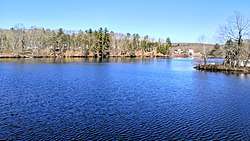
The Little River at Hanover Reservoir.
Country United States
State Connecticut
Towns Hampton, Scotland, Canterbury, Sprague, Norwich
Physical characteristics
Main source Hampton Reservoir, Hampton
41°29′33″N 72°01′58″E / 41.4925°N 72.0328°E / 41.4925; 72.0328
River mouth Shetucket River, Occum, Norwich
41°21′15″N 72°01′30″E / 41.3542°N 72.0250°E / 41.3542; 72.0250Coordinates: 41°21′15″N 72°01′30″E / 41.3542°N 72.0250°E / 41.3542; 72.0250
Length 21.7 miles (34.9 km)
Width
  • Minimum width:
    12 feet (3.7 m)
  • Average width:
    64 feet (20 m)
  • Maximum width:
    240 feet (73 m)
Discharge
  • Location:
    Hanover, CT[1]
  • Minimum rate:
    24.2 cubic feet (0.69 m3), 2002 Annual Discharge
  • Average rate:
    68.1 cubic feet (1.93 m3)
  • Maximum rate:
    86.2 cubic feet (2.44 m3), 1984 Annual Discharge
Basin features
Basin size 30 square miles (78 km2)
Population 8,000
Tributaries
  • Left:
    Cedar Swamp Brook
  • Right:
    Downing Brook, Peck Brook
Waterbodies Hanover Reservoir, Papermill Pond, Versailles Pond
Bridges Route 97, US 6, Route 14, Route 138

The Little River is a river that runs through the towns of Hampton, Canterbury, Scotland, and Sprague, Connecticut. It begins at Hampton Reservoir in northern Hampton, CT and snakes its way down into the Shetucket River at the town borders of Norwich, Sprague, and Lisbon, CT[2][3][4]

Crossings

Whole River is in Connecticut

County Town Crossing Name Coordinates
Windham Hampton Airline State Park Trail 41°49′20″N 72°03′25″W / 41.8223°N 72.0570°W / 41.8223; -72.0570
Kenyon Rd. 41°49′13″N 72°03′24″W / 41.8204°N 72.0568°W / 41.8204; -72.0568
Route 97. 41°48′23″N 72°03′22″W / 41.8064°N 72.0562°W / 41.8064; -72.0562
Old Kings Highway 41°48′14″N 72°03′28″W / 41.8039°N 72.0578°W / 41.8039; -72.0578
Hammond Hill Rd. 41°47′35″N 72°03′02″W / 41.7930°N 72.0506°W / 41.7930; -72.0506
N. Bigelow Rd. 41°46′49″N 72°02′42″W / 41.7802°N 72.0450°W / 41.7802; -72.0450
E. Old Route 6 41°46′45″N 72°02′39″W / 41.7791°N 72.0443°W / 41.7791; -72.0443
US 6 41°46′18″N 72°02′37″W / 41.7718°N 72.0436°W / 41.7718; -72.0436
Drain St. 41°46′11″N 72°02′40″W / 41.7698°N 72.0444°W / 41.7698; -72.0444
Sand Hill Rd. 41°45′33″N 72°02′57″W / 41.7593°N 72.0493°W / 41.7593; -72.0493
Windham Rd. 41°44′36″N 72°03′09″W / 41.7432°N 72.0526°W / 41.7432; -72.0526
Scotland None
Canterbury Route 14 41°42′09″N 72°03′17″W / 41.7024°N 72.0548°W / 41.7024; -72.0548
Miller Goodwin Con. 41°41′36″N 72°02′57″W / 41.6932°N 72.0492°W / 41.6932; -72.0492
Woodchuck Hill Rd. 41°40′13″N 72°03′14″W / 41.6702°N 72.0538°W / 41.6702; -72.0538
New London Sprague Parkwood Rd. 41°38′50″N 72°03′38″W / 41.6472°N 72.0605°W / 41.6472; -72.0605
Potash Hill Rd. 41°38′21″N 72°03′28″W / 41.6391°N 72.0578°W / 41.6391; -72.0578
Route 138 41°36′54″N 72°02′32″W / 41.6150°N 72.0421°W / 41.6150; -72.0421
Providence and Worcester RR 41°36′50″N 72°02′35″W / 41.6140°N 72.0430°W / 41.6140; -72.0430
Riverside Rd. 41°35′59″N 72°02′44″W / 41.5998°N 72.0456°W / 41.5998; -72.0456
Main St./Inland Rd.
Norwich None/ End of River 41°35′41″N 72°02′51″W / 41.5947°N 72.0474°W / 41.5947; -72.0474

References

  1. "USGS Surface Water data for Connecticut: USGS Surface-Water Annual Statistics". nwis.waterdata.usgs.gov. Retrieved 2016-09-25.
  2. "LITTLE RIVER" (PDF). ct.gov. TOPOI. 1998. Retrieved July 29, 2016.
  3. Merly, Ron (2011-12-01). Flyfisher's Guide to Connecticut. Wilderness Adventures Press. ISBN 9781932098891.
  4. "GNIS Detail - Little River". geonames.usgs.gov. Retrieved 2016-08-01.
This article is issued from Wikipedia. The text is licensed under Creative Commons - Attribution - Sharealike. Additional terms may apply for the media files.