Aspetuck River
Coordinates: 41°13′55″N 73°19′23″W / 41.2319°N 73.3231°W
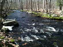
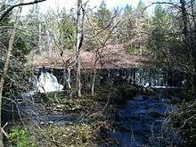
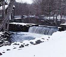
The Aspetuck River is a 17.0-mile-long (27.4 km)[1] river in the U.S. state of Connecticut. The river rises in the hills located in Huntington State Park in Bethel, with a watershed of approximately 430 acres (170 ha).[2] The river flows generally southerly through Redding, Connecticut to the Aspetuck Reservoir, the Hemlock Reservoir in Easton and Fairfield and finally into the Saugatuck River in Westport, Connecticut and then into the Long Island Sound. It flows through the village of Aspetuck at an average depth of 2.5 feet (0.76 m).[3] The word Aspetuck can be translated as "river originating at the high place" in an Algonquian language.[4]
Recreation
Hiking
The Aspetuck Valley Trail is a Blue-Blazed Trail that follows the general course of the river.
Water quality
The Aspetuck is one of the cleanest rivers in the state, with an AA rating.[5]
See also
References
- ↑ U.S. Geological Survey. National Hydrography Dataset high-resolution flowline data. The National Map Archived 2012-04-05 at WebCite, accessed April 1, 2011
- ↑ "Archived copy". Archived from the original on 2010-12-27. Retrieved 2010-09-24.
- ↑ http://waterdata.usgs.gov/ct/nwis/uv/?site_no=01209105&PARAmeter_cd=00065,00060
- ↑ "Archived copy". Archived from the original on 2010-11-16. Retrieved 2010-09-24.
- ↑ "Archived copy". Archived from the original on 2010-08-16. Retrieved 2010-09-24.