| Name |
Image |
Location |
Coordinates |
Year first lit |
Automated |
Year deactivated |
Current Lens |
Focal Height |
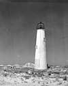
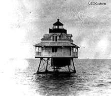
| Alligator Reef Light |
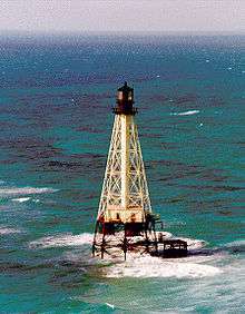 |
Islamorada |
24°51′6″N 80°37′6″W / 24.85167°N 80.61833°W / 24.85167; -80.61833 (Alligator Reef Light) |
1873 |
1963 |
2015[1]
(Replaced) |
VRB-25 |
136 136 ft (41 m) |
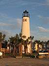
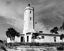
| Amelia Island Light |
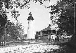 |
Fernandina Beach
(Amelia Island) |
30°40′23.46″N 81°26′32.8″W / 30.6731833°N 81.442444°W / 30.6731833; -81.442444 (Amelia Island Light) |
1838 |
1970[2] |
Active |
Unknown |
107 107 ft (33 m) |
| Amelia Island North Range Light |
 |
St. Mary's River
(Mouth) |
30°42′09″N 81°26′26″W / 30.70250°N 81.44056°W / 30.70250; -81.44056 (Amelia Island North Range Light) |
1858 (First)
1872 (Last) |
Never |
1899
(Destroyed by 1925) |
None |
030 30 ft (9.1 m) |
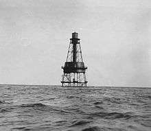
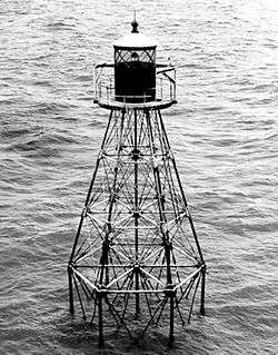
| American Shoal Light |
 |
Saddlebunch Keys |
24°31′30″N 81°31′12″W / 24.52500°N 81.52000°W / 24.52500; -81.52000 (American Shoal Light) |
1880 |
1963 |
2015[3]
(Replaced) |
VRB-25 |
109 109 ft (33 m) |
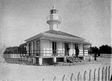
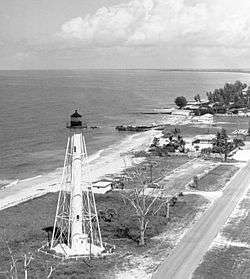
| Anclote Keys Light |
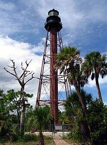 |
Tarpon Springs
(Anclote Key) |
28°10′01.11″N 82°50′40.74″W / 28.1669750°N 82.8446500°W / 28.1669750; -82.8446500 (Anclote Keys Light) |
1887 |
1952 |
Active
(Inactive: 1984-2003) |
Fourth-order Fresnel
(Replica) |
110 110 ft (34 m) |
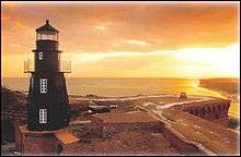
Cape Canaveral Light
(Old) |
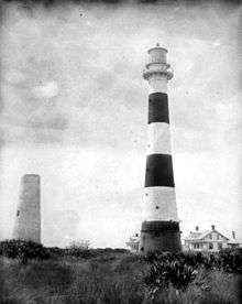 |
Cape Canaveral
(Cape Canaveral Air Force Station) |
28°27′36.8″N 80°31′37.9″W / 28.460222°N 80.527194°W / 28.460222; -80.527194 (Cape Canaveral Light 1848) |
1848 |
Never |
1868
(Demolished in 1893) |
None |
060 60 ft (18 m) |
Cape Canaveral Light
(New) |
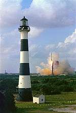 |
Cape Canaveral
(Cape Canaveral Air Force Station) |
28°27′37.26″N 80°32′36.42″W / 28.4603500°N 80.5434500°W / 28.4603500; -80.5434500 (Cape Canaveral Light) |
1868 |
1960 |
Active |
DCB-224 |
137 137 ft (42 m) |
| Cape Florida Light |
 |
Cape Florida |
25°39′59.72″N 80°09′21.47″W / 25.6665889°N 80.1559639°W / 25.6665889; -80.1559639 (Cape Florida Light) |
1825
(First)
1847
(Current) |
1978 |
Active
(Inactive: 1878-1978) |
300mm |
095 95 ft (29 m) |
| Cape San Blas Light |
 |
Cape San Blas |
29°40′16.41″N 85°21′22.72″W / 29.6712250°N 85.3563111°W / 29.6712250; -85.3563111 (Cape San Blas Light) |
1848
(First)
1885
(Current) |
1981 |
1996 |
None |
101 101 ft (31 m) |
| Cape St. George Light (Old) |
 |
Cape St. George Island
(Apalachicola Bay) |
29°35′15.2″N 85°02′49.32″W / 29.587556°N 85.0470333°W / 29.587556; -85.0470333 (Cape St. George Light) |
1852 |
1949 |
2005
(Collapsed) |
None |
072 72 ft (22 m) |
| Cape St. George Light (New) |
 |
Cape St. George Island
(Apalachicola Bay) |
29°39′46.1″N 84°51′45.2″W / 29.662806°N 84.862556°W / 29.662806; -84.862556 (Cape St. George Light) |
2008
(Replica) |
Always |
Active |
Third-order Fresnel
(Replica) |
072 72 ft (22 m) |
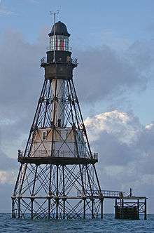
| Carysfort Reef Light |
 |
Key Largo
(Carysfort Reef) |
25°13′18″N 80°12′42″W / 25.22167°N 80.21167°W / 25.22167; -80.21167 (Carysfort Reef Light) |
1852 |
1962 |
2014 |
None |
100 100 ft (30 m) |
| Cedar Key Light |
 |
Cedar Key |
29°05′47.33″N 83°03′55″W / 29.0964806°N 83.06528°W / 29.0964806; -83.06528 (Cedar Key Light) |
1854 |
Never |
1915 |
None |
075 75 ft (23 m) |
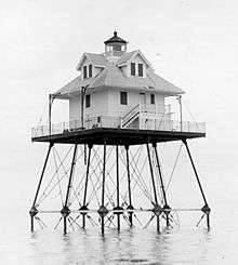
| Charlotte Harbor Light |
 |
Punta Gorda |
26°45′35″N 82°06′29″W / 26.75972°N 82.10806°W / 26.75972; -82.10806 (Charlotte Harbor Light) |
1890 |
1918 |
1943
(Demolished) |
None |
036 36 ft (11 m) |
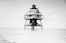
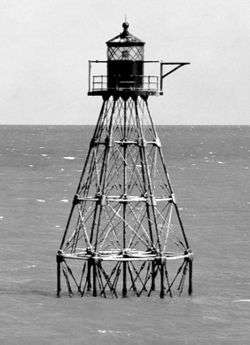
| Cosgrove Shoal Light |
N/A |
Marquesas Keys |
24°27′28.44″N 82°11′6.16″W / 24.4579000°N 82.1850444°W / 24.4579000; -82.1850444 (Cosgrove Shoal Light) |
1935 |
Always |
Active |
200mm |
054 54 ft (16 m) |
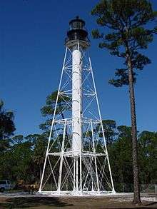
| Crooked River Light |
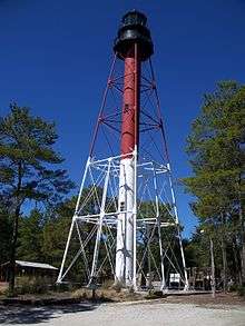 |
Carrabelle
(Dog Island) |
29°49′39″N 84°42′04″W / 29.82750°N 84.70111°W / 29.82750; -84.70111 (Crooked River Light) |
1895 |
1952 |
Active
(Inactive: 1995-2007) |
Fourth-order Fresnel
(Replica) |
115 115 ft (35 m) |
| Dames Point Light |
N/A |
Jacksonville |
30°23′00″N 81°33′16″W / 30.38333°N 81.55444°W / 30.38333; -81.55444 (Dames Point Light) |
1872 |
Never |
1893
(Destroyed in 1913) |
None |
035 35 ft (11 m) |
| Dog Island Light |
 |
Carrabelle
(Dog Island) |
29°47′N 84°40′W / 29.783°N 84.667°W / 29.783; -84.667 (Dog Island Light) |
1839 (First)
1872 (Last) |
Never |
1873
(Destroyed and replaced) |
None |
070 70 ft (21 m) |
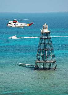
| Dry Tortugas Light |
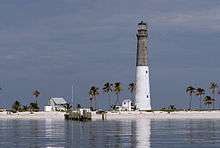 |
Loggerhead Key
(Dry Tortugas) |
24°38′00″N 82°55′12″W / 24.63333°N 82.92000°W / 24.63333; -82.92000 (Dry Tortugas Light) |
1858 |
1988 |
Active |
VRB-25 |
151 151 ft (46 m) |
| Egmont Key Light |
 |
St. Petersburg
(Tampa Bay) |
27°36′03″N 82°45′39″W / 27.60083°N 82.76083°W / 27.60083; -82.76083 (Egmont Key Light) |
1848
(First)
1858
(Current) |
1990 |
Active |
DCB-24 |
085 85 ft (26 m) |
| Fowey Rocks Light |
 |
Key Biscayne |
25°35′26.25″N 80°05′48.24″W / 25.5906250°N 80.0967333°W / 25.5906250; -80.0967333 (Fowey Rocks Light) |
1878 |
1975 |
Active |
VRB-25 |
110 110 ft (34 m) |
| Garden Key Light |
 |
Fort Jefferson
(Dry Tortugas National Park) |
24°37′41″N 82°52′20″W / 24.62806°N 82.87222°W / 24.62806; -82.87222 (Garden Key Light) |
1826
(First)
1877
(Current) |
1912 |
1924 |
Decorative |
070 70 ft (21 m) |
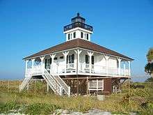
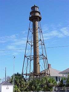
| Gasparilla Island Light |
 |
Boca Grande |
26°43′02″N 82°15′39″W / 26.71722°N 82.26083°W / 26.71722; -82.26083 (Boca Grande Light Rear) |
1932 |
1956 |
1966 |
None |
105 105 ft (32 m) |
| Hen and Chickens Shoal Light |
N/A |
Plantation Key |
24°55′58.69″N 80°32′55.36″W / 24.9329694°N 80.5487111°W / 24.9329694; -80.5487111 (Hen and Chickens Shoal Light) |
1929 |
Always |
Active |
Acetylene |
035 35 ft (11 m) |
| Hillsboro Inlet Light |
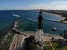 |
Hillsboro Beach
(Hillsboro Inlet) |
26°15′33″N 80°04′51″W / 26.25917°N 80.08083°W / 26.25917; -80.08083 (Hillsboro Inlet Light) |
1907 |
1974 |
Active |
Second-order Fresnel |
136 136 ft (41 m) |
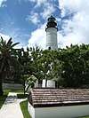
| Jupiter Inlet Light |
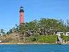 |
Jupiter |
26°56′55″N 80°04′55″W / 26.94861°N 80.08194°W / 26.94861; -80.08194 (Jupiter Inlet Light) |
1860 |
1928 |
Active |
Unknown |
146 146 ft (45 m) |
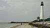
| Key West Light |
 |
Key West |
24°33′2.16″N 81°48′2.52″W / 24.5506000°N 81.8007000°W / 24.5506000; -81.8007000 (Key West Light) |
1826
(First)
1849
(Current) |
1915 |
1969
(Now a museum) |
None |
091 91 ft (28 m) |
| Molasses Reef Light |
 |
Key Largo
(Molasses Reef) |
25°00′42.66″N 80°22′35.31″W / 25.0118500°N 80.3764750°W / 25.0118500; -80.3764750 (Molasses Reef Light) |
1921 |
Always |
Active[4] |
Unknown |
045 45 ft (14 m) |
| Northwest Passage Light |
 |
Key West |
24°37′8.31″N 81°53′56.71″W / 24.6189750°N 81.8990861°W / 24.6189750; -81.8990861 (Northwest Passage Light) |
1855 (First)
1879 (Last) |
1911 |
1971
(Destroyed) |
None |
047 47 ft (14 m) |
| Pacific Reef Light |
 |
Elliott Key |
25°22′15.55″N 80°08′31.41″W / 25.3709861°N 80.1420583°W / 25.3709861; -80.1420583 (Pacific Reef Light) |
1921 |
Always |
Active |
Unknown |
044 44 ft (13 m) |
| Pensacola Light |
 |
Pensacola
(Pensacola Bay) |
30°20′47″N 87°18′29″W / 30.34639°N 87.30806°W / 30.34639; -87.30806 (Pensacola Light) |
1824
(First)
1859
(Current) |
1965 |
Active |
First-order Fresnel |
191 191 ft (58 m) |
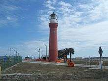
| Ponce de Leon Inlet Light |
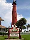 |
Ponce Inlet |
29°04′49″N 80°55′41″W / 29.08028°N 80.92806°W / 29.08028; -80.92806 (Ponce de Leon Inlet Light) |
1887 |
1953 |
Active
(Inactive: 1970-1982) |
Third-order Fresnel |
159 159 ft (48 m) |
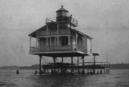
| Port Boca Grande Light |
 |
Boca Grande
(Gasparilla Island) |
26°43′02″N 82°15′39″W / 26.71722°N 82.26083°W / 26.71722; -82.26083 (Port Boca Grande Light) |
1890 |
1956 |
Active
(Inactive: 1966-1986) |
377mm |
041 41 ft (12 m) |
| Pulaski Shoal Light |
 |
Key West |
24°41′36.02″N 82°46′22.79″W / 24.6933389°N 82.7729972°W / 24.6933389; -82.7729972 (Pulaski Shoal Light) |
1935
(First)
Unknown
(Current) |
Always |
Active |
Unknown |
049 49 ft (15 m) |
| Rebecca Shoal Light |
 |
Marquesas Keys |
24°34′42″N 82°35′06″W / 24.57833°N 82.58500°W / 24.57833; -82.58500 (Rebecca Shoal Light) |
1886 |
1926 |
1953
(Demolished) |
None |
066 66 ft (20 m) |
| Sand Key Light |
 |
Key West |
24°27′14.18″N 81°52′39.02″W / 24.4539389°N 81.8775056°W / 24.4539389; -81.8775056 (Sand Key Light) |
1827
(First)
1853
(Current) |
1941 |
2014
(Replaced) |
VRB-25 |
109 109 ft (33 m) |
| Sanibel Island Light |
 |
Sanibel |
26°27′10.51″N 82°00′51.32″W / 26.4529194°N 82.0142556°W / 26.4529194; -82.0142556 (Sanibel Island Light) |
1884 |
1949 |
Active |
190mm |
098 98 ft (30 m) |
| Smith Shoal Light |
N/A |
Key West |
24°43′5.82″N 81°55′17.54″W / 24.7182833°N 81.9215389°W / 24.7182833; -81.9215389 (Smith Shoal Light) |
1933
(First)
Unknown
(Current) |
Always |
Active |
Unknown |
049 49 ft (15 m) |
| Sombrero Key Light |
 |
Marathon |
24°37′40.46″N 81°06′41.78″W / 24.6279056°N 81.1116056°W / 24.6279056; -81.1116056 (Sombrero Key Light) |
1858 |
1960 |
2015
(Replaced) |
None |
142 142 ft (43 m) |
| St. Augustine Light (Old) |
 |
St. Augustine
(Anastasia Island) |
N/A |
1824[5]A |
Never |
1874
(Destroyed in 1880) |
None |
052 52 ft (16 m) |
| St. Augustine Light (New) |
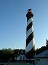 |
St. Augustine
(Anastasia Island) |
29°53′08″N 81°17′19″W / 29.88556°N 81.28861°W / 29.88556; -81.28861 (St. Augustine Light) |
1874 |
1955 |
Active |
First-order Fresnel |
161 161 ft (49 m) |
| St. Johns Light |
 |
Atlantic Beach |
30°23′10″N 81°23′53″W / 30.38611°N 81.39806°W / 30.38611; -81.39806 (St. Johns Light) |
1954 |
1967 |
Active |
VRB-25 |
083 83 ft (25 m) |
| St. Johns River Light |
 |
Atlantic Beach |
30°23′36.77″N 81°25′33.49″W / 30.3935472°N 81.4259694°W / 30.3935472; -81.4259694 (St. Johns River Light) |
1830
(First)
1858
(Last) |
Never |
1929 |
None |
081 81 ft (25 m) |
| St. Joseph Bay Light |
N/A |
St. Joseph Peninsula |
29°53′N 85°23′W / 29.883°N 85.383°W / 29.883; -85.383 (St. Joseph Bay Light) |
1839 |
Never |
1847B
(Lens moved) |
None |
050 50 ft (15 m) |
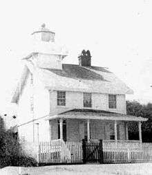
| St. Joseph Point Rear Range Light |
 |
Apalachicola
(St. Joseph Bay) |
29°55′5.67″N 85°22′49.79″W / 29.9182417°N 85.3804972°W / 29.9182417; -85.3804972 (St. Joseph Point Rear Range Light) |
1902 |
Never |
1960C |
None |
078 78 ft (24 m) |
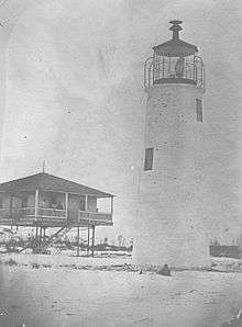
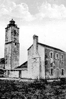
| St. Marks Light (Old) |
 |
St. Marks |
N/A |
1831 |
Never |
1842
(Demolished) |
None |
065 65 ft (20 m) |
| St. Marks Light (New) |
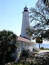 |
St. Marks |
30°04′19″N 84°10′48″W / 30.07194°N 84.18000°W / 30.07194; -84.18000 (St. Marks Light) |
1842 |
1960 |
Active |
Unknown |
082 82 ft (25 m) |
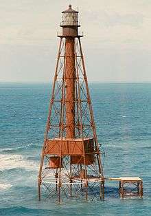
| Tennessee Reef Light |
 |
Long Key |
24°44′45.88″N 80°46′56.47″W / 24.7460778°N 80.7823528°W / 24.7460778; -80.7823528 (Tennessee Reef Light) |
1933 |
Always |
Active |
Unknown |
049 49 ft (15 m) |
| Volusia Bar Light |
 |
Lake George |
29°12′24″N 81°34′46″W / 29.20667°N 81.57944°W / 29.20667; -81.57944 (Volusia Bar Light) |
1886 |
Never |
1916
(Destroyed in 1974) |
None |
034 34 ft (10 m) |