List of listed buildings in Lesmahagow Parish, South Lanarkshire
This is a list of listed buildings in the parish of Lesmahagow in South Lanarkshire, Scotland.
List
| Name | Location | Date Listed | Grid Ref. [note 1] | Geo-coordinates | Notes | HB Number [note 2] | Image |
|---|---|---|---|---|---|---|---|
| Auchlochan Bridge | 55°37′06″N 3°53′26″W / 55.618364°N 3.890596°W | Category B | 7688 |  | |||
| Folkerton Mill | 55°36′12″N 3°48′56″W / 55.603329°N 3.815692°W | Category B | 7695 | | |||
| Old Lesmahagow Church, And Graveyard | 55°38′18″N 3°53′07″W / 55.638235°N 3.885325°W | Category B | 7675 | | |||
| Craignethan Castle | 55°41′46″N 3°53′06″W / 55.696088°N 3.885006°W | Category A | 7677 | 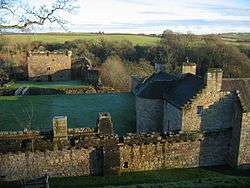 | |||
| West Hawksland | 55°38′21″N 3°49′57″W / 55.639233°N 3.832526°W | Category C(S) | 7694 | | |||
| Birkwood, South Lodge And Gateway, New Trows Road | 55°37′45″N 3°53′40″W / 55.62917°N 3.89442°W | Category B | 7699 | | |||
| Lesmahagow Village, Royal Bank Of Scotland Including Boundary Walls And Gatepiers | 55°38′24″N 3°53′12″W / 55.640076°N 3.886557°W | Category B | 7701 | | |||
| Kirkmuirhill Parish Church (United Presbyterian Church) Including Railings And Church Hall | 55°39′53″N 3°54′36″W / 55.66486°N 3.909897°W | Category C(S) | 48138 | | |||
| Turfholm Bridge | 55°38′03″N 3°53′11″W / 55.63429°N 3.886438°W | Category C(S) | 7676 | | |||
| Corra Castle | 55°39′12″N 3°46′40″W / 55.653319°N 3.777872°W | Category A | 7680 | 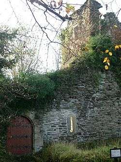 | |||
| Clydevale | 55°42′05″N 3°51′59″W / 55.701372°N 3.866259°W | Category B | 7686 | | |||
| 81/83 Lanark Road Crossford Village | 55°41′55″N 3°52′06″W / 55.698562°N 3.868417°W | Category C(S) | 7687 | | |||
| Birkhill, Including Stable Wing | 55°36′00″N 3°50′41″W / 55.600135°N 3.84483°W | Category B | 7692 | | |||
| Birkwood House | 55°37′59″N 3°53′22″W / 55.632951°N 3.889344°W | Category B | 7698 | | |||
| Auchenheath House Including Coach House, Garden Terraces And Balustrades, South Entrance Gatepiers And Walls | 55°40′15″N 3°54′00″W / 55.670882°N 3.900014°W | Category B | 51053 | | |||
| 162 Riverside Road, Kirkfieldbank | 55°40′30″N 3°48′25″W / 55.674893°N 3.807063°W | Category C(S) | 44600 | | |||
| Douglasmouth Bridge | 55°37′51″N 3°45′55″W / 55.630773°N 3.765334°W | Category B | 7689 | | |||
| Stables, Harperfield | 55°38′18″N 3°45′47″W / 55.638303°N 3.762924°W | Category C(S) | 7691 | | |||
| Lesmahagow Village, Old Roadbridge West Of Milton Road/Carlisle Junction At Ngr 8145 4054 | 55°38′38″N 3°53′06″W / 55.643927°N 3.885074°W | Category B | 7703 | | |||
| West Toun, Coalburn, Statue Of A Highlander | 55°35′01″N 3°51′39″W / 55.583698°N 3.860861°W | Category B | 13402 | | |||
| Lesmahagow Village, Abbeygreen Parish Church And Manse Including Boundary Walls And Gatepiers | 55°38′27″N 3°53′12″W / 55.640775°N 3.886718°W | Category B | 11729 | | |||
| Off New Trows Road, Birkwood South Driveway Bridge | 55°37′49″N 3°53′39″W / 55.630189°N 3.894231°W | Category C(S) | 11726 | | |||
| Dovecot, Blackwood House | 55°40′06″N 3°56′55″W / 55.668249°N 3.948701°W | Category B | 7678 | | |||
| Corehouse, Dovecot | 55°39′13″N 3°46′54″W / 55.653659°N 3.781702°W | Category C(S) | 7681 | | |||
| Crossford Bridge | 55°41′51″N 3°52′01″W / 55.697514°N 3.867014°W | Category B | 7684 | | |||
| Greenrig | 55°39′34″N 3°49′09″W / 55.659375°N 3.819065°W | Category B | 7693 | | |||
| Nos 15-19 Bereholm, Lesmahagow | 55°38′14″N 3°53′06″W / 55.637312°N 3.885121°W | Category B | 7696 | | |||
| Lesmahagow Village, Old Bridge West Of Milton Road At Ngr Ns 8148 4044 | 55°38′35″N 3°53′04″W / 55.642992°N 3.884552°W | Category B | 7700 | | |||
| Corehouse Conservatory And Flower Garden Walls, Gatepiers And Gates | 55°39′17″N 3°46′53″W / 55.654678°N 3.781478°W | Category B | 51595 | | |||
| Corehouse Stable Court Including Gatepiers And Boundary Wall | 55°39′10″N 3°46′57″W / 55.652685°N 3.782596°W | Category B | 51596 | | |||
| Corehouse, Mausoleum | 55°39′23″N 3°46′59″W / 55.65647°N 3.783117°W | Category C(S) | 7682 | | |||
| Harperfield | 55°38′17″N 3°45′42″W / 55.638025°N 3.761625°W | Category B | 7690 | | |||
| Stonebyres Coach House And Adjoining Buildings | 55°40′20″N 3°50′42″W / 55.672252°N 3.844979°W | Category B | 7697 | | |||
| Corehouse Stove House (Or Vinery) | 55°39′19″N 3°46′54″W / 55.655178°N 3.781692°W | Category C(S) | 51597 | | |||
| 185 New Trows Road, Birkwood, West Lodge | 55°38′01″N 3°53′35″W / 55.633577°N 3.893076°W | Category B | 11725 | | |||
| Abbeygreen Road, Birkwood, Driveway Bridge Over River Nethan | 55°38′03″N 3°53′11″W / 55.63429°N 3.886438°W | Category B | 11727 | | |||
| Birkwood, Walled Garden | 55°37′59″N 3°53′08″W / 55.633182°N 3.885447°W | Category B | 11728 | | |||
| Corehouse | 55°39′17″N 3°46′41″W / 55.654846°N 3.777973°W | Category A | 7679 | 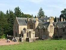 | |||
| No. 1 Braidwood Road, Crossford | 55°41′52″N 3°52′04″W / 55.697683°N 3.867675°W | Category B | 7685 | | |||
| Lesmahagow Village, Milton Bridge, A74 | 55°38′40″N 3°53′07″W / 55.644518°N 3.885245°W | Category B | 7702 | |
Key
The scheme for classifying buildings in Scotland is:
- Category A: "buildings of national or international importance, either architectural or historic; or fine, little-altered examples of some particular period, style or building type."[1]
- Category B: "buildings of regional or more than local importance; or major examples of some particular period, style or building type, which may have been altered."[1]
- Category C: "buildings of local importance; lesser examples of any period, style, or building type, as originally constructed or moderately altered; and simple traditional buildings which group well with other listed buildings."[1]
In March 2016 there were 47,288 listed buildings in Scotland. Of these, 8 per cent were Category A, and 50 per cent were Category B, with the rest listed at Category C.[2]
Notes
- ↑ Sometimes known as OSGB36, the grid reference (where provided) is based on the British national grid reference system used by the Ordnance Survey.
• "Guide to National Grid". Ordnance Survey. Retrieved 2007-12-12.
• "Get-a-map". Ordnance Survey. Retrieved 2007-12-17. - ↑ The "HB Number" is a unique number assigned to each listed building by Historic Environment Scotland.
References
- All entries, addresses and coordinates are based on data from Historic Scotland. This data falls under the Open Government Licence
- 1 2 3 "What is Listing?". Historic Environment Scotland. Retrieved 29 May 2018.
- ↑ Scotland's Historic Environment Audit 2016 (PDF). Historic Environment Scotland and the Built Environment Forum Scotland. pp. 15–16. Retrieved 29 May 2018.
This article is issued from
Wikipedia.
The text is licensed under Creative Commons - Attribution - Sharealike.
Additional terms may apply for the media files.