| Name |
Location |
Date Listed |
Grid Ref. [note 1] |
Geo-coordinates |
Notes |
HB Number [note 2] |
Image |
| Newbigging, Dunsyre Road, Thatched Building |
|
|
|
55°41′54″N 3°34′03″W / 55.698363°N 3.567362°W / 55.698363; -3.567362 (Newbigging, Dunsyre Road, Thatched Building) |
Category C(S) |
6457 |

|
| Smithy And Smithy Cottages, Newbigging |
|
|
|
55°41′52″N 3°34′04″W / 55.697766°N 3.567656°W / 55.697766; -3.567656 (Smithy And Smithy Cottages, Newbigging) |
Category C(S) |
699 |
|
| Auchengray Church |
|
|
|
55°46′08″N 3°36′07″W / 55.768916°N 3.602042°W / 55.768916; -3.602042 (Auchengray Church) |
Category B |
707 |
|
| Braehead Village, Braehead Church |
|
|
|
55°44′15″N 3°40′11″W / 55.737378°N 3.669861°W / 55.737378; -3.669861 (Braehead Village, Braehead Church) |
Category B |
674 |
|
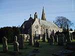
| Old Collegiate Church, "St. Mary's Aisle", And Graveyard |
|
|
|
55°42′01″N 3°37′55″W / 55.700291°N 3.631806°W / 55.700291; -3.631806 (Old Collegiate Church, "St. Mary's Aisle", And Graveyard) |
Category A |
692 |
 Upload another image
|
| Nos. 74-78 Main Street |
|
|
|
55°42′02″N 3°37′30″W / 55.700427°N 3.624905°W / 55.700427; -3.624905 (Nos. 74-78 Main Street) |
Category B |
697 |
|
| Westshield |
|
|
|
55°43′32″N 3°40′49″W / 55.725618°N 3.680202°W / 55.725618; -3.680202 (Westshield) |
Category B |
702 |
|
| Tomb, Scabhill |
|
|
|
55°43′55″N 3°40′40″W / 55.731988°N 3.677673°W / 55.731988; -3.677673 (Tomb, Scabhill) |
Category C(S) |
704 |
|
| Mausoleum Near Fordmouth Bridge |
|
|
|
55°44′23″N 3°37′43″W / 55.739838°N 3.628534°W / 55.739838; -3.628534 (Mausoleum Near Fordmouth Bridge) |
Category C(S) |
708 |
|
| Ampherlaw Farmhouse And Steading Including Boundary Walls And Gatepiers |
|
|
|
55°44′27″N 3°36′52″W / 55.740763°N 3.614316°W / 55.740763; -3.614316 (Ampherlaw Farmhouse And Steading Including Boundary Walls And Gatepiers) |
Category C(S) |
50150 |
|
| Carnwath Cross |
|
|
|
55°42′01″N 3°37′33″W / 55.700281°N 3.625743°W / 55.700281; -3.625743 (Carnwath Cross) |
Category A |
694 |
|
| Estate Office |
|
|
|
55°42′01″N 3°37′56″W / 55.700247°N 3.632345°W / 55.700247; -3.632345 (Estate Office) |
Category C(S) |
696 |
|
| Eastshield |
|
|
|
55°43′56″N 3°39′27″W / 55.732207°N 3.657568°W / 55.732207; -3.657568 (Eastshield) |
Category B |
703 |
|
| Kersewell House, Walled Garden Including Pheasantry |
|
|
|
55°42′29″N 3°34′47″W / 55.707972°N 3.579747°W / 55.707972; -3.579747 (Kersewell House, Walled Garden Including Pheasantry) |
Category B |
676 |
|
| Carnwath, Garmonie (Former Carnwath Manse) |
|
|
|
55°41′58″N 3°37′51″W / 55.699333°N 3.630811°W / 55.699333; -3.630811 (Carnwath, Garmonie (Former Carnwath Manse)) |
Category B |
695 |
|
| New Bush Inn |
|
|
|
55°42′03″N 3°37′26″W / 55.700764°N 3.623901°W / 55.700764; -3.623901 (New Bush Inn) |
Category B |
698 |
|
| Cleuch House And Walled Garden |
|
|
|
55°46′08″N 3°40′05″W / 55.768883°N 3.668035°W / 55.768883; -3.668035 (Cleuch House And Walled Garden) |
Category C(S) |
709 |
|
| Newbigging, Market Cross |
|
|
|
55°41′48″N 3°34′06″W / 55.696669°N 3.568392°W / 55.696669; -3.568392 (Newbigging, Market Cross) |
Category A |
5093 |
|
| Ampherlaw House And Dovecot |
|
|
|
55°44′24″N 3°36′49″W / 55.74007°N 3.61373°W / 55.74007; -3.61373 (Ampherlaw House And Dovecot) |
Category B |
706 |
|
| Dovecot Cleugh House |
|
|
|
55°46′04″N 3°40′03″W / 55.767846°N 3.667624°W / 55.767846; -3.667624 (Dovecot Cleugh House) |
Category B |
710 |
|
| Biggar Road, King George's Park, Carnwath Sports Pavilion |
|
|
|
55°41′59″N 3°37′36″W / 55.699694°N 3.626689°W / 55.699694; -3.626689 (Biggar Road, King George's Park, Carnwath Sports Pavilion) |
Category C(S) |
51593 |
|
| Kersewell House |
|
|
|
55°42′30″N 3°34′49″W / 55.708235°N 3.580267°W / 55.708235; -3.580267 (Kersewell House) |
Category B |
675 |
|
| Carnwath Parish Church |
|
|
|
55°42′01″N 3°37′54″W / 55.700348°N 3.63157°W / 55.700348; -3.63157 (Carnwath Parish Church) |
Category B |
700 |
|
| Parish Church Hall |
|
|
|
55°42′02″N 3°37′45″W / 55.700639°N 3.629274°W / 55.700639; -3.629274 (Parish Church Hall) |
Category C(S) |
693 |
|
| Couthalley Castle |
|
|
|
55°42′58″N 3°38′21″W / 55.71599°N 3.639242°W / 55.71599; -3.639242 (Couthalley Castle) |
Category B |
701 |
|
| Pigeon Tower, Lawhead |
|
|
|
55°46′13″N 3°33′19″W / 55.770397°N 3.555283°W / 55.770397; -3.555283 (Pigeon Tower, Lawhead) |
Category C(S) |
705 |
|