List of listed buildings in Cambuslang, South Lanarkshire
This is a list of listed buildings in the parish of Cambuslang in South Lanarkshire, Scotland.
List
| Name | Location | Date Listed | Grid Ref. [note 1] | Geo-coordinates | Notes | HB Number [note 2] | Image |
|---|---|---|---|---|---|---|---|
| Central Avenue, 5 Beech Avenue, Ashfield Including Boundary Walls And Gatepiers | 55°49′07″N 4°10′31″W / 55.818717°N 4.175401°W | Category B | 33792 |  | |||
| Flemington Farm (Off Flemington Road) | 55°48′06″N 4°07′39″W / 55.801786°N 4.127594°W | Category B | 33665 | 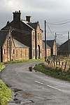 | |||
| Cambuslang, 13 Tabernacle Lane, Masonic Hall | 55°49′06″N 4°09′56″W / 55.818317°N 4.16553°W | Category C(S) | 49643 | .jpg) | |||
| 2 Glasgow Road, Beech Avenue, Trinity Parish Church And Halls, Boundary Walls, Gates And Gatepiers | 55°49′11″N 4°10′30″W / 55.819678°N 4.174928°W | Category B | 33794 | .jpg) | |||
| 6, 6A, 8 Milton Avenue, Wellshot House | 55°49′04″N 4°10′50″W / 55.817798°N 4.180649°W | Category B | 33796 | | |||
| Greenlees Road And 2 Tabernacle Street, Former Cambuslang Public School | 55°49′04″N 4°10′01″W / 55.817763°N 4.16684°W | Category B | 33666 | 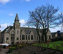 | |||
| Cairns Road, Cambuslang Old Parish Church Including Churchyard, Boundary Walls, Gates And Gatepiers | 55°48′50″N 4°09′47″W / 55.813858°N 4.163°W | Category B | 33659 | 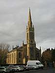 | |||
| 63, 65 West Coats Road, Including Boundary Walls And Gatepiers | 55°48′58″N 4°10′32″W / 55.816233°N 4.17563°W | Category B | 33797 | | |||
| Gilbertfield Castle | 55°48′11″N 4°09′02″W / 55.802967°N 4.150651°W | Category B | 1060 | 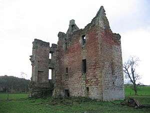 | |||
| Burnside Road, Church Avenue, Burnside Parish Church Including Halls, Session House, Boundary Walls And Railings | 55°48′51″N 4°11′59″W / 55.814042°N 4.199768°W | Category B | 33788 | 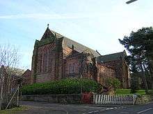 | |||
| Waterside | 55°46′46″N 4°14′18″W / 55.779363°N 4.238399°W | Category C(S) | 6630 | | |||
| 60, Brownside Road, West Coats Primary School Including Boundary Walls, Gatepiers, Gates And Railings | 55°48′56″N 4°10′32″W / 55.815508°N 4.175462°W | Category B | 33787 | 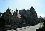 | |||
| 2A Cadzow Drive, Greenlees Road, Cambuslang Baptist Church Including Boundary Walls, Gates And Railings | 55°48′58″N 4°10′02″W / 55.816076°N 4.167209°W | Category C(S) | 33790 | .jpg) | |||
| 25 Central Avenue, Hotel | 55°49′09″N 4°10′44″W / 55.819277°N 4.178849°W | Category B | 33791 | | |||
| 4 Central Avenue, 21 Wellshot Drive | 55°49′05″N 4°10′28″W / 55.818151°N 4.174428°W | Category B | 33793 | | |||
| Main Street, Savoy Bingo Club (Former Savoy Cinema) | 55°49′07″N 4°09′58″W / 55.818514°N 4.166067°W | Category C(S) | 51158 | | |||
| 4 Busheyhill Street, Former School | 55°49′03″N 4°10′03″W / 55.817572°N 4.167516°W | Category B | 33789 | 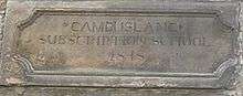 | |||
| 37 Greenlees Road, Cambuslang Institute Including Boundary Walls | 55°49′00″N 4°10′03″W / 55.816591°N 4.167573°W | Category B | 33795 | 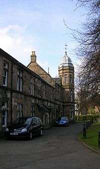 | |||
| Clydeford Road, Dovecot At Cambuslang Golf Course | 55°49′19″N 4°09′44″W / 55.821879°N 4.162279°W | Category B | 33664 | 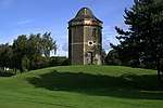 | |||
| 7, 7A Cairns Road, Cambuslang Old Parish Church Hall | 55°48′49″N 4°09′44″W / 55.813493°N 4.162341°W | Category C(S) | 33660 | 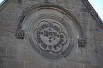 |
Key
The scheme for classifying buildings in Scotland is:
- Category A: "buildings of national or international importance, either architectural or historic; or fine, little-altered examples of some particular period, style or building type."[1]
- Category B: "buildings of regional or more than local importance; or major examples of some particular period, style or building type, which may have been altered."[1]
- Category C: "buildings of local importance; lesser examples of any period, style, or building type, as originally constructed or moderately altered; and simple traditional buildings which group well with other listed buildings."[1]
In March 2016 there were 47,288 listed buildings in Scotland. Of these, 8 per cent were Category A, and 50 per cent were Category B, with the rest listed at Category C.[2]
Notes
- ↑ Sometimes known as OSGB36, the grid reference (where provided) is based on the British national grid reference system used by the Ordnance Survey.
• "Guide to National Grid". Ordnance Survey. Retrieved 2007-12-12.
• "Get-a-map". Ordnance Survey. Retrieved 2007-12-17. - ↑ The "HB Number" is a unique number assigned to each listed building by Historic Environment Scotland.
References
- All entries, addresses and coordinates are based on data from Historic Scotland. This data falls under the Open Government Licence
- 1 2 3 "What is Listing?". Historic Environment Scotland. Retrieved 29 May 2018.
- ↑ Scotland's Historic Environment Audit 2016 (PDF). Historic Environment Scotland and the Built Environment Forum Scotland. pp. 15–16. Retrieved 29 May 2018.
This article is issued from
Wikipedia.
The text is licensed under Creative Commons - Attribution - Sharealike.
Additional terms may apply for the media files.