| Name |
Location |
Date Listed |
Grid Ref. [note 1] |
Geo-coordinates |
Notes |
HB Number [note 2] |
Image |
| 4 Kirkstyle |
|
|
|
55°37′28″N 3°31′31″W / 55.624388°N 3.525227°W / 55.624388; -3.525227 (4 Kirkstyle) |
Category B |
22253 |

|
| 8 Kirkstyle |
|
|
|
55°37′28″N 3°31′31″W / 55.624503°N 3.525326°W / 55.624503; -3.525326 (8 Kirkstyle) |
Category C(S) |
22255 |
|
| Moat Park Church Kirkstyle |
|
|
|
55°37′29″N 3°31′35″W / 55.624606°N 3.526442°W / 55.624606; -3.526442 (Moat Park Church Kirkstyle) |
Category B |
22259 |
|
| 27 And 29 High Street |
|
|
|
55°37′23″N 3°31′37″W / 55.622947°N 3.526854°W / 55.622947; -3.526854 (27 And 29 High Street) |
Category C(S) |
22176 |
|
| 55 High Street |
|
|
|
55°37′25″N 3°31′34″W / 55.623569°N 3.526037°W / 55.623569; -3.526037 (55 High Street) |
Category C(S) |
22185 |
|
| Part Of 81 High Street, & 83 High Street, In Wynd To Rear |
|
|
|
55°37′29″N 3°31′28″W / 55.624784°N 3.524416°W / 55.624784; -3.524416 (Part Of 81 High Street, & 83 High Street, In Wynd To Rear) |
Category C(S) |
22196 |
|
| 97 & 99 High Street |
|
|
|
55°37′28″N 3°31′25″W / 55.624578°N 3.523646°W / 55.624578; -3.523646 (97 & 99 High Street) |
Category C(S) |
22199 |
|
| 105 & 107 High Street |
|
|
|
55°37′29″N 3°31′24″W / 55.624634°N 3.523457°W / 55.624634; -3.523457 (105 & 107 High Street) |
Category B |
22200 |
|
| Crown Hotel, (109 & 111) High Street |
|
|
|
55°37′29″N 3°31′24″W / 55.624852°N 3.523291°W / 55.624852; -3.523291 (Crown Hotel, (109 & 111) High Street) |
Category B |
22201 |
|
| 125, 127 And 129 High Street |
|
|
|
55°37′29″N 3°31′22″W / 55.624743°N 3.522683°W / 55.624743; -3.522683 (125, 127 And 129 High Street) |
Category B |
22202 |
|
| 135 High Street (At Rear Of 133) (Smith's Close) |
|
|
|
55°37′29″N 3°31′21″W / 55.624764°N 3.522414°W / 55.624764; -3.522414 (135 High Street (At Rear Of 133) (Smith's Close)) |
Category C(S) |
22204 |
|
| Elphinstone Hotel, High Street |
|
|
|
55°37′30″N 3°31′18″W / 55.624997°N 3.521725°W / 55.624997; -3.521725 (Elphinstone Hotel, High Street) |
Category B |
22207 |
|
| 169 High Street |
|
|
|
55°37′30″N 3°31′16″W / 55.625051°N 3.52098°W / 55.625051; -3.52098 (169 High Street) |
Category C(S) |
22213 |
|
| 213 High Street |
|
|
|
55°37′33″N 3°31′11″W / 55.625777°N 3.519722°W / 55.625777; -3.519722 (213 High Street) |
Category C(S) |
22217 |
|
| 10, 12 And 14 High Street |
|
|
|
55°37′21″N 3°31′38″W / 55.622431°N 3.527215°W / 55.622431; -3.527215 (10, 12 And 14 High Street) |
Category C(S) |
22222 |
|
| 94 & 96 High Street |
|
|
|
55°37′27″N 3°31′24″W / 55.624178°N 3.523297°W / 55.624178; -3.523297 (94 & 96 High Street) |
Category C(S) |
22233 |
|
| Braebourne 182 High Street |
|
|
|
55°37′33″N 3°31′09″W / 55.62572°N 3.519211°W / 55.62572; -3.519211 (Braebourne 182 High Street) |
Category B |
22248 |
|
| Lindsaylands |
|
|
|
55°37′12″N 3°32′47″W / 55.620035°N 3.546289°W / 55.620035; -3.546289 (Lindsaylands) |
Category B |
6461 |
|
| Biggar Park South Lodge, Including Walls, Gatepiers And Railings |
|
|
|
55°37′05″N 3°32′10″W / 55.61807°N 3.536033°W / 55.61807; -3.536033 (Biggar Park South Lodge, Including Walls, Gatepiers And Railings) |
Category C(S) |
5100 |
|
| Station Road, Former Railway Station, Including Principal Building With Wash House, Signal Box, Outbuilding And Goods Shed |
|
|
|
55°37′10″N 3°31′36″W / 55.6194°N 3.526669°W / 55.6194; -3.526669 (Station Road, Former Railway Station, Including Principal Building With Wash House, Signal Box, Outbuilding And Goods Shed) |
Category B |
44553 |
|
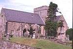
| St Mary's Church Kirkstyle |
|
|
|
55°37′30″N 3°31′31″W / 55.625132°N 3.525367°W / 55.625132; -3.525367 (St Mary's Church Kirkstyle) |
Category A |
22257 |
 Upload another image
|
| St Mary's Church-Graveyard Kirkstyle |
|
|
|
55°37′31″N 3°31′31″W / 55.625392°N 3.525409°W / 55.625392; -3.525409 (St Mary's Church-Graveyard Kirkstyle) |
Category B |
22258 |
|
| Kirkhouse, Carwood Road |
|
|
|
55°37′40″N 3°31′33″W / 55.627714°N 3.525864°W / 55.627714; -3.525864 (Kirkhouse, Carwood Road) |
Category B |
22269 |
|
| Station Road, 1 And 2 Station Cottages |
|
|
|
55°37′10″N 3°31′41″W / 55.619464°N 3.528068°W / 55.619464; -3.528068 (Station Road, 1 And 2 Station Cottages) |
Category C(S) |
22270 |
|
| The Camb 4 Coulter Road |
|
|
|
55°37′18″N 3°31′46″W / 55.621703°N 3.529331°W / 55.621703; -3.529331 (The Camb 4 Coulter Road) |
Category B |
22169 |
|
| 25. High Street |
|
|
|
55°37′22″N 3°31′38″W / 55.622899°N 3.527122°W / 55.622899; -3.527122 (25. High Street) |
Category C(S) |
22175 |
|
| 43. High Street |
|
|
|
55°37′23″N 3°31′36″W / 55.623158°N 3.526529°W / 55.623158; -3.526529 (43. High Street) |
Category B |
22179 |
|
| 51A High Street |
|
|
|
55°37′25″N 3°31′35″W / 55.623555°N 3.526385°W / 55.623555; -3.526385 (51A High Street) |
Category C(S) |
22184 |
|
| 61 High Street (Manse) |
|
|
|
55°37′27″N 3°31′36″W / 55.624288°N 3.5267°W / 55.624288; -3.5267 (61 High Street (Manse)) |
Category C(S) |
22187 |
|
| 63 & 65 High Street |
|
|
|
55°37′26″N 3°31′31″W / 55.624°N 3.525323°W / 55.624; -3.525323 (63 & 65 High Street) |
Category C(S) |
22188 |
|
| 32 High Street |
|
|
|
55°37′23″N 3°31′34″W / 55.62292°N 3.52617°W / 55.62292; -3.52617 (32 High Street) |
Category B |
22226 |
|
| 74, 76 & 78 High Street |
|
|
|
55°37′26″N 3°31′26″W / 55.623999°N 3.523925°W / 55.623999; -3.523925 (74, 76 & 78 High Street) |
Category C(S) |
22230 |
|
| 98 & 100 High Street |
|
|
|
55°37′27″N 3°31′23″W / 55.624216°N 3.523092°W / 55.624216; -3.523092 (98 & 100 High Street) |
Category C(S) |
22234 |
|
| Royal Bank Of Scotland 104 High Street |
|
|
|
55°37′27″N 3°31′23″W / 55.624209°N 3.522965°W / 55.624209; -3.522965 (Royal Bank Of Scotland 104 High Street) |
Category B |
22235 |
|
| 164 And 166 High Street |
|
|
|
55°37′30″N 3°31′10″W / 55.625051°N 3.519535°W / 55.625051; -3.519535 (164 And 166 High Street) |
Category C(S) |
22244 |
|
| High House Of Edmonston |
|
|
|
55°39′50″N 3°28′45″W / 55.663843°N 3.479291°W / 55.663843; -3.479291 (High House Of Edmonston) |
Category B |
636 |
|
| Edmonston |
|
|
|
55°39′53″N 3°28′40″W / 55.664706°N 3.477733°W / 55.664706; -3.477733 (Edmonston) |
Category B |
637 |
|
| 2 North Back Road |
|
|
|
55°37′28″N 3°31′31″W / 55.624522°N 3.525264°W / 55.624522; -3.525264 (2 North Back Road) |
Category C(S) |
22260 |
|
| 71 High Street |
|
|
|
55°37′27″N 3°31′29″W / 55.624105°N 3.524787°W / 55.624105; -3.524787 (71 High Street) |
Category C(S) |
22190 |
|
| 85 & 87 High Street |
|
|
|
55°37′28″N 3°31′27″W / 55.624564°N 3.524074°W / 55.624564; -3.524074 (85 & 87 High Street) |
Category C(S) |
22197 |
|
| 131 And 133 High Street |
|
|
|
55°37′29″N 3°31′21″W / 55.624791°N 3.522399°W / 55.624791; -3.522399 (131 And 133 High Street) |
Category B |
22203 |
|
| Fleming Arms, High Street |
|
|
|
55°37′30″N 3°31′20″W / 55.624991°N 3.522264°W / 55.624991; -3.522264 (Fleming Arms, High Street) |
Category B |
22206 |
|
| 153 High Street |
|
|
|
55°37′30″N 3°31′18″W / 55.624935°N 3.521643°W / 55.624935; -3.521643 (153 High Street) |
Category C(S) |
22209 |
|
| 205 High Street |
|
|
|
55°37′32″N 3°31′12″W / 55.625657°N 3.519987°W / 55.625657; -3.519987 (205 High Street) |
Category C(S) |
22215 |
|
| 8 High Street |
|
|
|
55°37′20″N 3°31′39″W / 55.622294°N 3.527369°W / 55.622294; -3.527369 (8 High Street) |
Category B |
22221 |
|
| 80, 82 & 84 High Street |
|
|
|
55°37′26″N 3°31′25″W / 55.62393°N 3.523732°W / 55.62393; -3.523732 (80, 82 & 84 High Street) |
Category C(S) |
22231 |
|
| 86 & 88 High Street |
|
|
|
55°37′27″N 3°31′25″W / 55.624112°N 3.523564°W / 55.624112; -3.523564 (86 & 88 High Street) |
Category C(S) |
22232 |
|
| Buildings To Rear Of 136, 138 High Street |
|
|
|
55°37′28″N 3°31′15″W / 55.624533°N 3.520785°W / 55.624533; -3.520785 (Buildings To Rear Of 136, 138 High Street) |
Category C(S) |
22241 |
|
| 162 High Street |
|
|
|
55°37′30″N 3°31′10″W / 55.624961°N 3.519579°W / 55.624961; -3.519579 (162 High Street) |
Category C(S) |
22243 |
|
| 168 High Street |
|
|
|
55°37′31″N 3°31′10″W / 55.625141°N 3.519554°W / 55.625141; -3.519554 (168 High Street) |
Category C(S) |
22245 |
|
| Cormiston House And Steading |
|
|
|
55°37′10″N 3°34′24″W / 55.619339°N 3.573464°W / 55.619339; -3.573464 (Cormiston House And Steading) |
Category B |
6585 |
|
| Lindsaylands, Lodge And Gatepiers |
|
|
|
55°37′11″N 3°32′32″W / 55.619656°N 3.542146°W / 55.619656; -3.542146 (Lindsaylands, Lodge And Gatepiers) |
Category B |
6462 |
|
| Lindsaylands, Stables |
|
|
|
55°37′14″N 3°32′46″W / 55.62054°N 3.546166°W / 55.62054; -3.546166 (Lindsaylands, Stables) |
Category B |
6463 |
|
| Brownsbank Cottage |
|
|
|
55°39′41″N 3°28′19″W / 55.661379°N 3.471933°W / 55.661379; -3.471933 (Brownsbank Cottage) |
Category A |
640 |
|
| Building At Rear Of Brookside, The Wynd, |
|
|
|
55°37′29″N 3°31′42″W / 55.62469°N 3.528335°W / 55.62469; -3.528335 (Building At Rear Of Brookside, The Wynd,) |
Category C(S) |
22266 |
|
| 8 The Wynd |
|
|
|
55°37′22″N 3°31′42″W / 55.622739°N 3.528418°W / 55.622739; -3.528418 (8 The Wynd) |
Category C(S) |
22267 |
|
| 37 And 39 High Street |
|
|
|
55°37′23″N 3°31′36″W / 55.623119°N 3.526766°W / 55.623119; -3.526766 (37 And 39 High Street) |
Category B |
22178 |
|
| 57 High Street |
|
|
|
55°37′25″N 3°31′33″W / 55.623633°N 3.525928°W / 55.623633; -3.525928 (57 High Street) |
Category C(S) |
22186 |
|
| 77 & 79 High Street |
|
|
|
55°37′28″N 3°31′28″W / 55.624525°N 3.524311°W / 55.624525; -3.524311 (77 & 79 High Street) |
Category C(S) |
22193 |
|
| Part Of 81 High Street, In Wynd To Rear |
|
|
|
55°37′29″N 3°31′28″W / 55.624605°N 3.52433°W / 55.624605; -3.52433 (Part Of 81 High Street, In Wynd To Rear) |
Category B |
22195 |
|
| 20 High Street |
|
|
|
55°37′21″N 3°31′37″W / 55.622586°N 3.527015°W / 55.622586; -3.527015 (20 High Street) |
Category C(S) |
22224 |
|
| 34 And 36 High Street |
|
|
|
55°37′23″N 3°31′34″W / 55.623047°N 3.526112°W / 55.623047; -3.526112 (34 And 36 High Street) |
Category C(S) |
22227 |
|
| 116, 118 & 120 High Street |
|
|
|
55°37′28″N 3°31′20″W / 55.624316°N 3.522286°W / 55.624316; -3.522286 (116, 118 & 120 High Street) |
Category C(S) |
22239 |
|
| 7 Kirkstyle |
|
|
|
55°37′26″N 3°31′33″W / 55.623869°N 3.525762°W / 55.623869; -3.525762 (7 Kirkstyle) |
Category C(S) |
22251 |
|
| 2 Kirkstyle |
|
|
|
55°37′28″N 3°31′31″W / 55.624343°N 3.525161°W / 55.624343; -3.525161 (2 Kirkstyle) |
Category B |
22252 |
|
| Biggar Mill And Millhouse |
|
|
|
55°37′36″N 3°31′39″W / 55.626697°N 3.527397°W / 55.626697; -3.527397 (Biggar Mill And Millhouse) |
Category B |
6371 |
|
| Langlees Road, Langlees House And Lodge |
|
|
|
55°37′30″N 3°32′29″W / 55.62511°N 3.541455°W / 55.62511; -3.541455 (Langlees Road, Langlees House And Lodge) |
Category B |
5101 |
|
| 6 Kirkstyle |
|
|
|
55°37′28″N 3°31′31″W / 55.624459°N 3.525277°W / 55.624459; -3.525277 (6 Kirkstyle) |
Category B |
22254 |
|
| 16 South Back Road |
|
|
|
55°37′26″N 3°31′16″W / 55.624015°N 3.52121°W / 55.624015; -3.52121 (16 South Back Road) |
Category C(S) |
22261 |
|
| 5 Smiths Close |
|
|
|
55°37′30″N 3°31′21″W / 55.625014°N 3.522583°W / 55.625014; -3.522583 (5 Smiths Close) |
Category C(S) |
22263 |
|
| 4 James Square Smiths Close |
|
|
|
55°37′30″N 3°31′22″W / 55.624922°N 3.522738°W / 55.624922; -3.522738 (4 James Square Smiths Close) |
Category C(S) |
22264 |
|
| 2, Gasworks Road |
|
|
|
55°37′24″N 3°31′39″W / 55.623345°N 3.527425°W / 55.623345; -3.527425 (2, Gasworks Road) |
Category A |
22171 |
|
| Cadger's Brig High Street |
|
|
|
55°37′21″N 3°31′41″W / 55.622583°N 3.527999°W / 55.622583; -3.527999 (Cadger's Brig High Street) |
Category A |
22173 |
|
| 33 And 35 High Street |
|
|
|
55°37′23″N 3°31′36″W / 55.623057°N 3.5267°W / 55.623057; -3.5267 (33 And 35 High Street) |
Category B |
22177 |
|
| 45. High Street |
|
|
|
55°37′24″N 3°31′35″W / 55.623285°N 3.52647°W / 55.623285; -3.52647 (45. High Street) |
Category B |
22180 |
|
| 47. High Street |
|
|
|
55°37′24″N 3°31′34″W / 55.623369°N 3.526219°W / 55.623369; -3.526219 (47. High Street) |
Category B |
22181 |
|
| Gable End Between Elphinstone Hotel And 153 High Street |
|
|
|
55°37′30″N 3°31′19″W / 55.62496°N 3.521818°W / 55.62496; -3.521818 (Gable End Between Elphinstone Hotel And 153 High Street) |
Category C(S) |
22208 |
|
| 165 High Street |
|
|
|
55°37′30″N 3°31′16″W / 55.625075°N 3.521219°W / 55.625075; -3.521219 (165 High Street) |
Category B |
22212 |
|
| 201 High Street |
|
|
|
55°37′32″N 3°31′12″W / 55.625664°N 3.520115°W / 55.625664; -3.520115 (201 High Street) |
Category C(S) |
22214 |
|
| 207, 209 High Street |
|
|
|
55°37′32″N 3°31′11″W / 55.625659°N 3.519844°W / 55.625659; -3.519844 (207, 209 High Street) |
Category C(S) |
22216 |
|
| 215 High Street |
|
|
|
55°37′33″N 3°31′11″W / 55.62585°N 3.519645°W / 55.62585; -3.519645 (215 High Street) |
Category B |
22218 |
|
| 30 High Street |
|
|
|
55°37′22″N 3°31′35″W / 55.622782°N 3.526451°W / 55.622782; -3.526451 (30 High Street) |
Category B |
22225 |
|
| 180 High Street |
|
|
|
55°37′32″N 3°31′09″W / 55.625665°N 3.519305°W / 55.625665; -3.519305 (180 High Street) |
Category C(S) |
22247 |
|
| Biggar Park Mansion House |
|
|
|
55°37′07″N 3°32′19″W / 55.618513°N 3.538655°W / 55.618513; -3.538655 (Biggar Park Mansion House) |
Category B |
5098 |
|
| Boghall Castle |
|
|
|
55°37′01″N 3°31′29″W / 55.61681°N 3.524662°W / 55.61681; -3.524662 (Boghall Castle) |
Category B |
635 |
|
| 24 South Back Road |
|
|
|
55°37′25″N 3°31′24″W / 55.623746°N 3.523328°W / 55.623746; -3.523328 (24 South Back Road) |
Category B |
22262 |
|
| 49. High Street |
|
|
|
55°37′24″N 3°31′34″W / 55.623452°N 3.526064°W / 55.623452; -3.526064 (49. High Street) |
Category B |
22182 |
|
| 69 High Street |
|
|
|
55°37′27″N 3°31′31″W / 55.624082°N 3.525231°W / 55.624082; -3.525231 (69 High Street) |
Category C(S) |
22189 |
|
| 73 High Street |
|
|
|
55°37′27″N 3°31′29″W / 55.624141°N 3.524836°W / 55.624141; -3.524836 (73 High Street) |
Category C(S) |
22191 |
|
| 89, 91 & 93 High Street |
|
|
|
55°37′28″N 3°31′26″W / 55.624557°N 3.523852°W / 55.624557; -3.523852 (89, 91 & 93 High Street) |
Category B |
22198 |
|
| 155 High Street |
|
|
|
55°37′30″N 3°31′18″W / 55.624972°N 3.521581°W / 55.624972; -3.521581 (155 High Street) |
Category B |
22210 |
|
| 72 High Street |
|
|
|
55°37′26″N 3°31′28″W / 55.62383°N 3.524538°W / 55.62383; -3.524538 (72 High Street) |
Category B |
22229 |
|
| 114 High Street |
|
|
|
55°37′28″N 3°31′21″W / 55.624306°N 3.522412°W / 55.624306; -3.522412 (114 High Street) |
Category C(S) |
22237 |
|
| Doocot At Rear Of 116 - 120 High Street |
|
|
|
55°37′26″N 3°31′20″W / 55.624001°N 3.522321°W / 55.624001; -3.522321 (Doocot At Rear Of 116 - 120 High Street) |
Category C(S) |
22238 |
|
| 160 High Street |
|
|
|
55°37′30″N 3°31′11″W / 55.624923°N 3.519768°W / 55.624923; -3.519768 (160 High Street) |
Category C(S) |
22242 |
|
| Biggar Park, Stables And Outbuildings |
|
|
|
55°37′05″N 3°32′23″W / 55.618086°N 3.539766°W / 55.618086; -3.539766 (Biggar Park, Stables And Outbuildings) |
Category B |
5099 |
|
| Carwood House |
|
|
|
55°38′42″N 3°31′47″W / 55.644894°N 3.529599°W / 55.644894; -3.529599 (Carwood House) |
Category B |
639 |
|
| Building To Rear Of 8 The Wynd |
|
|
|
55°37′23″N 3°31′42″W / 55.622919°N 3.528457°W / 55.622919; -3.528457 (Building To Rear Of 8 The Wynd) |
Category C(S) |
22268 |
|
| Crosskeys Hotel, High Street |
|
|
|
55°37′22″N 3°31′40″W / 55.622684°N 3.527781°W / 55.622684; -3.527781 (Crosskeys Hotel, High Street) |
Category C(S) |
22174 |
|
| Davaar, High Street |
|
|
|
55°37′28″N 3°31′29″W / 55.624465°N 3.524769°W / 55.624465; -3.524769 (Davaar, High Street) |
Category B |
22192 |
|
| 81 High Street |
|
|
|
55°37′28″N 3°31′27″W / 55.624508°N 3.524231°W / 55.624508; -3.524231 (81 High Street) |
Category B |
22194 |
|
| 137 And 139 High Street |
|
|
|
55°37′29″N 3°31′20″W / 55.62482°N 3.522258°W / 55.62482; -3.522258 (137 And 139 High Street) |
Category C(S) |
22205 |
|
| 219 High Street |
|
|
|
55°37′33″N 3°31′10″W / 55.625923°N 3.519537°W / 55.625923; -3.519537 (219 High Street) |
Category B |
22219 |
|
| 16 High Street |
|
|
|
55°37′21″N 3°31′38″W / 55.622495°N 3.527107°W / 55.622495; -3.527107 (16 High Street) |
Category C(S) |
22223 |
|
| Royal Bank Of Scotland 58 High Street |
|
|
|
55°37′25″N 3°31′31″W / 55.623489°N 3.525255°W / 55.623489; -3.525255 (Royal Bank Of Scotland 58 High Street) |
Category C(S) |
22228 |
|
| 178 High Street |
|
|
|
55°37′32″N 3°31′09″W / 55.625603°N 3.51927°W / 55.625603; -3.51927 (178 High Street) |
Category C(S) |
22246 |
|
| Mossdale, 184 High Street |
|
|
|
55°37′33″N 3°31′09″W / 55.625758°N 3.519086°W / 55.625758; -3.519086 (Mossdale, 184 High Street) |
Category B |
22249 |
|
| Ross Square At Rear Of 182 High Street |
|
|
|
55°37′32″N 3°31′09″W / 55.625676°N 3.51913°W / 55.625676; -3.51913 (Ross Square At Rear Of 182 High Street) |
Category C(S) |
22250 |
|
| Edmonston Mill |
|
|
|
55°39′36″N 3°28′26″W / 55.659955°N 3.473787°W / 55.659955; -3.473787 (Edmonston Mill) |
Category B |
638 |
|
| Church Hall, Kirkstyle |
|
|
|
55°37′28″N 3°31′33″W / 55.624398°N 3.525846°W / 55.624398; -3.525846 (Church Hall, Kirkstyle) |
Category C(S) |
22256 |
|
| Brookside, The Wynd |
|
|
|
55°37′22″N 3°31′42″W / 55.622805°N 3.528214°W / 55.622805; -3.528214 (Brookside, The Wynd) |
Category C(S) |
22265 |
|
| Gas Showrooms, Gasworks Road |
|
|
|
55°37′24″N 3°31′40″W / 55.623412°N 3.527777°W / 55.623412; -3.527777 (Gas Showrooms, Gasworks Road) |
Category A |
22170 |
|
| Biggar Gasworks |
|
|
|
55°37′24″N 3°31′41″W / 55.62323°N 3.527945°W / 55.62323; -3.527945 (Biggar Gasworks) |
Category A |
22172 |
|
| 51. High Street |
|
|
|
55°37′24″N 3°31′35″W / 55.623385°N 3.526379°W / 55.623385; -3.526379 (51. High Street) |
Category B |
22183 |
|
| 161 And 163 High Street |
|
|
|
55°37′30″N 3°31′17″W / 55.625056°N 3.52133°W / 55.625056; -3.52133 (161 And 163 High Street) |
Category C(S) |
22211 |
|
| 2, 4 And 6 High Street |
|
|
|
55°37′20″N 3°31′39″W / 55.622282°N 3.527638°W / 55.622282; -3.527638 (2, 4 And 6 High Street) |
Category B |
22220 |
|
| 110 High Street |
|
|
|
55°37′27″N 3°31′21″W / 55.624241°N 3.522521°W / 55.624241; -3.522521 (110 High Street) |
Category C(S) |
22236 |
|
| Biggar Corn Exchange, High Street |
|
|
|
55°37′28″N 3°31′18″W / 55.624423°N 3.521655°W / 55.624423; -3.521655 (Biggar Corn Exchange, High Street) |
Category B |
22240 |
|