| Name |
Location |
Date Listed |
Grid Ref. [note 1] |
Geo-coordinates |
Notes |
HB Number [note 2] |
Image |
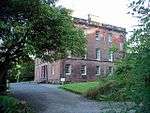
| Kirkwood House, Former Stables including Horsemill, Cottages and Kennels |
|
|
|
55°03′43″N 3°22′50″W / 55.06205°N 3.380644°W / 55.06205; -3.380644 (Kirkwood House, Former Stables including Horsemill, Cottages and Kennels) |
Category C(S) |
3373 |

|
| Almagill Hill, Monument to Joe Graham |
|
|
|
55°04′06″N 3°25′40″W / 55.068221°N 3.427649°W / 55.068221; -3.427649 (Almagill Hill, Monument to Joe Graham) |
Category B |
3452 |
|
| Dalton Village, Dalton Old Parish Church, Churchyard and Gatepiers |
|
|
|
55°03′09″N 3°23′17″W / 55.052378°N 3.387934°W / 55.052378; -3.387934 (Dalton Village, Dalton Old Parish Church, Churchyard and Gatepiers) |
Category A |
3455 |
.jpg) Upload another image
|
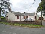
| Dalton Village, Kobe and Stan Court and Garage adjoining |
|
|
|
55°03′10″N 3°23′17″W / 55.0528°N 3.387949°W / 55.0528; -3.387949 (Dalton Village, Kobe and Stan Court and Garage adjoining) |
Category C(S) |
3456 |
|
| Rammerscales, Former Stables |
|
|
|
55°05′02″N 3°26′24″W / 55.084001°N 3.43993°W / 55.084001; -3.43993 (Rammerscales, Former Stables) |
Category B |
3796 |
|
| Manse Bridge (Minor Road Over Dalton Burn) |
|
|
|
55°03′21″N 3°23′42″W / 55.055884°N 3.394928°W / 55.055884; -3.394928 (Manse Bridge (Minor Road Over Dalton Burn)) |
Category C(S) |
3376 |
|
| Murraythwaite House, West Lodge |
|
|
|
55°02′31″N 3°22′19″W / 55.04183°N 3.37181°W / 55.04183; -3.37181 (Murraythwaite House, West Lodge) |
Category C(S) |
3377 |
|
| Hetland House |
|
|
|
55°02′10″N 3°25′25″W / 55.036023°N 3.423562°W / 55.036023; -3.423562 (Hetland House) |
Category B |
3464 |
|
| Dalton Village, Thistle Cottage |
|
|
|
55°03′08″N 3°23′06″W / 55.05233°N 3.385037°W / 55.05233; -3.385037 (Dalton Village, Thistle Cottage) |
Category C(S) |
3468 |
|
| Dormont, Williamwath Lodges |
|
|
|
55°04′17″N 3°23′06″W / 55.071444°N 3.385102°W / 55.071444; -3.385102 (Dormont, Williamwath Lodges) |
Category B |
3461 |
|
| Hetland Cottage (at Hetland Road-End) |
|
|
|
55°02′06″N 3°25′00″W / 55.035071°N 3.416612°W / 55.035071; -3.416612 (Hetland Cottage (at Hetland Road-End)) |
Category B |
3463 |
|
| Rammerscales, Garden Wall |
|
|
|
55°05′01″N 3°26′17″W / 55.083629°N 3.43799°W / 55.083629; -3.43799 (Rammerscales, Garden Wall) |
Category B |
3795 |
|
| Rammerscales House |
|
|
|
55°05′05″N 3°26′23″W / 55.084695°N 3.439736°W / 55.084695; -3.439736 (Rammerscales House) |
Category A |
3378 |
 Upload another image
|
| Dalton Village, School, Playground Walls and Gatepiers |
|
|
|
55°03′09″N 3°22′47″W / 55.052625°N 3.379662°W / 55.052625; -3.379662 (Dalton Village, School, Playground Walls and Gatepiers) |
Category C(S) |
3467 |
|
| Dormont Grange House |
|
|
|
55°03′38″N 3°23′32″W / 55.06056°N 3.392273°W / 55.06056; -3.392273 (Dormont Grange House) |
Category C(S) |
3474 |
|
| Dalton Village, Dalton Parish Church |
|
|
|
55°03′09″N 3°23′19″W / 55.052432°N 3.388656°W / 55.052432; -3.388656 (Dalton Village, Dalton Parish Church) |
Category B |
3458 |
.jpg) Upload another image
|
| Dalton Village, Old Schoolhouse |
|
|
|
55°03′07″N 3°23′06″W / 55.05199°N 3.384931°W / 55.05199; -3.384931 (Dalton Village, Old Schoolhouse) |
Category C(S) |
3457 |
 Upload another image
|
| Dalton Village, Finial from Old Parish Church |
|
|
|
55°03′09″N 3°23′17″W / 55.052378°N 3.387934°W / 55.052378; -3.387934 (Dalton Village, Finial from Old Parish Church) |
Category B |
3459 |
|
| Dormont, West Lodge and Gatepiers |
|
|
|
55°03′42″N 3°23′46″W / 55.061567°N 3.39616°W / 55.061567; -3.39616 (Dormont, West Lodge and Gatepiers) |
Category B |
3460 |
|
| Dalton Village, Rose Cottage |
|
|
|
55°03′09″N 3°23′08″W / 55.052619°N 3.385688°W / 55.052619; -3.385688 (Dalton Village, Rose Cottage) |
Category C(S) |
3466 |
|
| Denbie House |
|
|
|
55°02′35″N 3°23′34″W / 55.04312°N 3.392763°W / 55.04312; -3.392763 (Denbie House) |
Category A |
3469 |
|
| Denbie, Dovecot |
|
|
|
55°02′39″N 3°23′46″W / 55.044045°N 3.395988°W / 55.044045; -3.395988 (Denbie, Dovecot) |
Category A |
3470 |
|
| Denbie, Former Stables and Kennels |
|
|
|
55°02′35″N 3°23′44″W / 55.043114°N 3.395611°W / 55.043114; -3.395611 (Denbie, Former Stables and Kennels) |
Category B |
3472 |
|
| Kirkwood, West Lodge and Gatepiers |
|
|
|
55°03′48″N 3°23′07″W / 55.063391°N 3.385199°W / 55.063391; -3.385199 (Kirkwood, West Lodge and Gatepiers) |
Category C(S) |
3374 |
|
| Flosh Bridge |
|
|
|
55°03′46″N 3°23′53″W / 55.062732°N 3.398032°W / 55.062732; -3.398032 (Flosh Bridge) |
Category C(S) |
3462 |
|
| Kirkwood House |
|
|
|
55°03′49″N 3°22′37″W / 55.063556°N 3.377031°W / 55.063556; -3.377031 (Kirkwood House) |
Category B |
3465 |
|
| Denbie, Walled Garden |
|
|
|
55°02′34″N 3°23′35″W / 55.042703°N 3.393062°W / 55.042703; -3.393062 (Denbie, Walled Garden) |
Category B |
3471 |
|
| Rammerscales, Wellhead |
|
|
|
55°05′04″N 3°26′26″W / 55.084397°N 3.44065°W / 55.084397; -3.44065 (Rammerscales, Wellhead) |
Category B |
3794 |
|
| Williamwath Bridge over River Annan |
|
|
|
55°04′17″N 3°23′03″W / 55.071393°N 3.384051°W / 55.071393; -3.384051 (Williamwath Bridge over River Annan) |
Category B |
3797 |
.jpg) Upload another image
|
| Denbie, Lodge and Gatepiers |
|
|
|
55°02′41″N 3°24′03″W / 55.044655°N 3.40072°W / 55.044655; -3.40072 (Denbie, Lodge and Gatepiers) |
Category C(S) |
3473 |
|