List of listed buildings in Cummertrees, Dumfries and Galloway
| Wikimedia Commons has media related to Cummertrees. |
This is a list of listed buildings in the parish of Cummertrees in Dumfries and Galloway, Scotland.
List
| Name | Location | Date Listed | Grid Ref. [note 1] | Geo-coordinates | Notes | HB Number [note 2] | Image |
|---|---|---|---|---|---|---|---|
| Powfoot Village, Retaining Walls And Bridge, Pow Water | 54°58′45″N 3°19′50″W / 54.9793°N 3.330456°W | Category B | 6590 |  | |||
| Kinmount, Motor House (Garage Block) | 55°00′23″N 3°21′03″W / 55.006451°N 3.350697°W | Category B | 3540 | | |||
| Kinmount, Lodge at Hitchill, with Gates, Gatepiers and Railings | 54°59′39″N 3°20′26″W / 54.994053°N 3.340542°W | Category B | 3542 | | |||
| Lindrick Grange (Former Manse), Walled Garden and Old Manse | 54°59′23″N 3°21′03″W / 54.989796°N 3.350841°W | Category C(S) | 3547 | | |||
| Powfoot Village, 1-9 Bella Vista (inclusive Nos) | 54°58′44″N 3°19′53″W / 54.978787°N 3.331345°W | Category B | 3549 | | |||
| Glenstuart | 54°59′42″N 3°21′40″W / 54.995029°N 3.361099°W | Category C(S) | 3556 | | |||
| Powfoot Village, 1-8 Ellerslie (inclusive Nos) | 54°58′47″N 3°19′53″W / 54.979676°N 3.33139°W | Category B | 3566 | | |||
| Powfoot Village, 1-14 (Inclusive Nos) Lake View | 54°58′48″N 3°19′57″W / 54.979872°N 3.332366°W | Category B | 3568 | | |||
| 1-15 Queensberry Terrace (Inclusive Nos) | 54°59′09″N 3°20′16″W / 54.985727°N 3.337654°W | Category B | 3569 | | |||
| Hoddom Castle, Cistern House at Hoddom Mains | 55°02′23″N 3°19′02″W / 55.03962°N 3.317275°W | Category C(S) | 3577 | | |||
| Hoddom Castle, Walled Garden, Gardener's House, Hoddom Gardens Cottage and Sheds | 55°02′33″N 3°19′41″W / 55.042477°N 3.328058°W | Category B | 3579 | | |||
| Kinmount, Hannah Lodge, Gates, Gatepiers and Railings | 54°59′29″N 3°21′04″W / 54.991464°N 3.351194°W | Category B | 3539 | | |||
| Kinmount East Lodge and Gatepiers | 55°00′29″N 3°20′09″W / 55.008134°N 3.335852°W | Category B | 3545 | | |||
| Cummertrees Village, Cummertrees Parish Church With Churchyard And Lych Gate | 54°59′06″N 3°20′43″W / 54.984897°N 3.345253°W | Category C(S) | 3554 | | |||
| Cummertrees Village, Former Railway Station | 54°59′10″N 3°20′50″W / 54.986098°N 3.347231°W | Category B | 3555 | | |||
| Cummertrees Village, Cummertrees Mill, Mill House And Farm Buildings | 54°59′06″N 3°20′52″W / 54.984924°N 3.347723°W | Category B | 3553 | | |||
| Hitchill, Farmhouse And Steading Including Barn | 54°59′30″N 3°20′30″W / 54.991714°N 3.341589°W | Category B | 3557 | | |||
| Kinmount, Aviary (South West of Mansion) | 55°00′18″N 3°20′48″W / 55.00495°N 3.346675°W | Category B | 3559 | | |||
| Repentance Tower | 55°02′15″N 3°19′26″W / 55.037518°N 3.323794°W | Category A | 3570 | 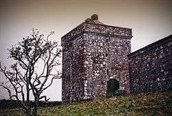 | |||
| Hoddom Castle, Footbridge over River Annan at Mainholm | 55°02′50″N 3°19′22″W / 55.047352°N 3.322757°W | Category B | 3578 | | |||
| Hoddom Castle, West Lodge And Gatepiers | 55°02′38″N 3°20′01″W / 55.043899°N 3.333677°W | Category B | 3581 | | |||
| Kinmount, Bathing House | 55°00′07″N 3°20′25″W / 55.001973°N 3.340353°W | Category B | 3583 | | |||
| Kinmount, Gooley Hill Queensberry Burial Enclosure | 55°00′03″N 3°20′24″W / 55.000699°N 3.340138°W | Category B | 3584 | | |||
| Kinmount, Former Stables | 55°00′25″N 3°21′00″W / 55.007007°N 3.349981°W | Category B | 3585 | | |||
| Kinmount, West Lodge | 55°00′42″N 3°21′12″W / 55.011743°N 3.353252°W | Category B | 3546 | | |||
| Hoddom Castle, Park House | 55°02′23″N 3°19′10″W / 55.039802°N 3.31955°W | Category B | 3580 | | |||
| Hoddom Castle with Fosse Bridge and Driveway Bridge to South | 55°02′37″N 3°19′20″W / 55.043564°N 3.322304°W | Category A | 3558 | 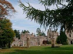 | |||
| Powfoot Village, Bridge over Pow Water | 54°58′45″N 3°19′50″W / 54.9793°N 3.330456°W | Category C(S) | 6591 | .jpg) | |||
| Kinmount House and Conservatory, with Office Court and Gateways | 55°00′19″N 3°20′45″W / 55.005374°N 3.345735°W | Category A | 3582 | 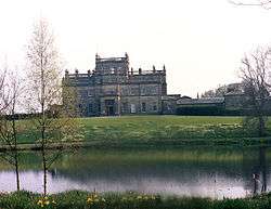 | |||
| Kinmount, Keeper's Cottage (To West Of Walled Garden) | 55°00′40″N 3°21′13″W / 55.011001°N 3.353696°W | Category C(S) | 3543 | | |||
| Kinmount, Queensberry House | 55°00′24″N 3°21′09″W / 55.006801°N 3.352382°W | Category B | 3544 | | |||
| Murraythwaite House and Stable Court | 55°02′26″N 3°22′02″W / 55.040543°N 3.367165°W | Category B | 3548 | | |||
| Trailtrow Burial Ground And Murray Aisle | 55°02′15″N 3°19′25″W / 55.037429°N 3.323682°W | Category B | 3571 | | |||
| Hoddom Castle, Piers To South Of Castle | 55°02′37″N 3°19′25″W / 55.043677°N 3.323497°W | Category B | 3575 | | |||
| Kinmount, Gatepiers and Quadrants at Main Drive | 55°00′32″N 3°20′18″W / 55.009006°N 3.338273°W | Category B | 3541 | | |||
| Cummertrees Village, Cummertrees House and Steading | 54°59′07″N 3°20′43″W / 54.985282°N 3.345391°W | Category C(S) | 3552 | | |||
| Powfoot Village, Holmside | 54°58′48″N 3°19′50″W / 54.97999°N 3.330557°W | Category B | 3567 | | |||
| Pow Water Gardens, Powfoot Bowling Pavilion, Powfoot | 54°58′45″N 3°19′53″W / 54.979236°N 3.331298°W | Category C(S) | 49464 | |
Key
The scheme for classifying buildings in Scotland is:
- Category A: "buildings of national or international importance, either architectural or historic; or fine, little-altered examples of some particular period, style or building type."[1]
- Category B: "buildings of regional or more than local importance; or major examples of some particular period, style or building type, which may have been altered."[1]
- Category C: "buildings of local importance; lesser examples of any period, style, or building type, as originally constructed or moderately altered; and simple traditional buildings which group well with other listed buildings."[1]
In March 2016 there were 47,288 listed buildings in Scotland. Of these, 8 per cent were Category A, and 50 per cent were Category B, with the rest listed at Category C.[2]
Notes
- ↑ Sometimes known as OSGB36, the grid reference (where provided) is based on the British national grid reference system used by the Ordnance Survey.
• "Guide to National Grid". Ordnance Survey. Retrieved 2007-12-12.
• "Get-a-map". Ordnance Survey. Retrieved 2007-12-17. - ↑ The "HB Number" is a unique number assigned to each listed building by Historic Environment Scotland.
References
- All entries, addresses and coordinates are based on data from Historic Scotland. This data falls under the Open Government Licence
- 1 2 3 "What is Listing?". Historic Environment Scotland. Retrieved 29 May 2018.
- ↑ Scotland's Historic Environment Audit 2016 (PDF). Historic Environment Scotland and the Built Environment Forum Scotland. pp. 15–16. Retrieved 29 May 2018.
This article is issued from
Wikipedia.
The text is licensed under Creative Commons - Attribution - Sharealike.
Additional terms may apply for the media files.