List of listed buildings in Caerlaverock, Dumfries and Galloway
| Wikimedia Commons has media related to Caerlaverock. |
This is a list of listed buildings in the parish of Caerlaverock in Dumfries and Galloway, Scotland.
List
| Name | Location | Date Listed | Grid Ref. [note 1] | Geo-coordinates | Notes | HB Number [note 2] | Image |
|---|---|---|---|---|---|---|---|
| Bankend Bridge (B725 Over Lochar Water) | 55°00′07″N 3°31′12″W / 55.001965°N 3.51987°W | Category B | 3798 | .jpg) | |||
| Conheath House | 55°00′43″N 3°34′10″W / 55.011816°N 3.569332°W | Category B | 3803 |  | |||
| Glencaple Quay | 55°00′10″N 3°34′27″W / 55.002668°N 3.574166°W | Category C(S) | 3807 | | |||
| Kirkconnel Lea Garden Steps To South Of House | 54°59′12″N 3°33′37″W / 54.986733°N 3.56021°W | Category C(S) | 3811 | | |||
| Caerlaverock House (Former Manse) | 55°00′30″N 3°31′40″W / 55.008301°N 3.527818°W | Category B | 3800 | | |||
| Conheath North Lodge and Gatepiers | 55°00′58″N 3°34′32″W / 55.015987°N 3.575548°W | Category B | 3805 | | |||
| Caerlaverock Castle and arched Gateway to North East | 54°58′33″N 3°31′27″W / 54.975787°N 3.524068°W | Category A | 3799 | 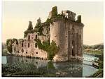 | |||
| Conheath Farm House | 55°00′50″N 3°34′18″W / 55.013995°N 3.571795°W | Category B | 3802 | | |||
| Kirkconnel Lea Garden Shed To North Of House | 54°59′14″N 3°33′39″W / 54.98731°N 3.560764°W | Category C(S) | 3810 | | |||
| Conheath Farm Steading Former Dovecot And Blocks Flanking Eastern Courtyard Entrance | 55°00′47″N 3°34′17″W / 55.013174°N 3.57134°W | Category B | 3814 | | |||
| Conheath Private Chapel | 55°00′32″N 3°34′17″W / 55.008957°N 3.571488°W | Category B | 3804 | | |||
| Kirkconnel Lea Sundial | 54°59′12″N 3°33′40″W / 54.986658°N 3.561177°W | Category C(S) | 3812 | | |||
| Caerlaverock Parish Church and Churchyard | 55°00′28″N 3°31′33″W / 55.007696°N 3.525825°W | Category B | 3801 | 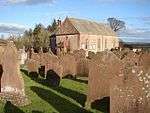 | |||
| Kirkconnel Lea House and Gatepiers | 54°59′13″N 3°33′37″W / 54.986902°N 3.560342°W | Category B | 3808 | | |||
| Kirkconnel Lea Double Well | 54°59′10″N 3°33′35″W / 54.986002°N 3.559729°W | Category C(S) | 3813 | | |||
| Kirkconnel Lea Castellated Folly | 54°59′12″N 3°33′40″W / 54.986658°N 3.561177°W | Category B | 3809 | | |||
| Conheath Walled Garden, Garden House And Summer House | 55°00′44″N 3°34′21″W / 55.012224°N 3.572585°W | Category B | 3806 | |
Key
The scheme for classifying buildings in Scotland is:
- Category A: "buildings of national or international importance, either architectural or historic; or fine, little-altered examples of some particular period, style or building type."[1]
- Category B: "buildings of regional or more than local importance; or major examples of some particular period, style or building type, which may have been altered."[1]
- Category C: "buildings of local importance; lesser examples of any period, style, or building type, as originally constructed or moderately altered; and simple traditional buildings which group well with other listed buildings."[1]
In March 2016 there were 47,288 listed buildings in Scotland. Of these, 8 per cent were Category A, and 50 per cent were Category B, with the rest listed at Category C.[2]
Notes
- ↑ Sometimes known as OSGB36, the grid reference (where provided) is based on the British national grid reference system used by the Ordnance Survey.
• "Guide to National Grid". Ordnance Survey. Retrieved 2007-12-12.
• "Get-a-map". Ordnance Survey. Retrieved 2007-12-17. - ↑ The "HB Number" is a unique number assigned to each listed building by Historic Environment Scotland.
References
- All entries, addresses and coordinates are based on data from Historic Scotland. This data falls under the Open Government Licence
- 1 2 3 "What is Listing?". Historic Environment Scotland. Retrieved 29 May 2018.
- ↑ Scotland's Historic Environment Audit 2016 (PDF). Historic Environment Scotland and the Built Environment Forum Scotland. pp. 15–16. Retrieved 29 May 2018.
This article is issued from
Wikipedia.
The text is licensed under Creative Commons - Attribution - Sharealike.
Additional terms may apply for the media files.