| Name |
Location |
Date Listed |
Grid Ref. [note 1] |
Geo-coordinates |
Notes |
HB Number [note 2] |
Image |
| Auldgirth Inn |
|
|
|
55°09′41″N 3°42′27″W / 55.161517°N 3.707616°W / 55.161517; -3.707616 (Auldgirth Inn) |
Category B |
3967 |
 Upload another image
|
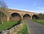
| Ballochan Linn Railway Viaduct |
|
|
|
55°10′10″N 3°42′44″W / 55.16948°N 3.712086°W / 55.16948; -3.712086 (Ballochan Linn Railway Viaduct) |
Category B |
3968 |

|
| Dalgarnock Old Burial Ground |
|
|
|
55°13′26″N 3°46′07″W / 55.223962°N 3.768668°W / 55.223962; -3.768668 (Dalgarnock Old Burial Ground) |
Category B |
4013 |
|
| Blackwood: House, Cottages and Walled Garden |
|
|
|
55°09′57″N 3°42′59″W / 55.165913°N 3.716502°W / 55.165913; -3.716502 (Blackwood: House, Cottages and Walled Garden) |
Category B |
4041 |
|
| Cample Viaduct |
|
|
|
55°13′45″N 3°44′05″W / 55.229295°N 3.734625°W / 55.229295; -3.734625 (Cample Viaduct) |
Category B |
4002 |
 Upload another image
|
| Claughrie |
|
|
|
55°10′50″N 3°42′30″W / 55.180424°N 3.708441°W / 55.180424; -3.708441 (Claughrie) |
Category B |
4003 |
|
| Locherben Farmhouse |
|
|
|
55°15′25″N 3°38′30″W / 55.256966°N 3.641781°W / 55.256966; -3.641781 (Locherben Farmhouse) |
Category C(S) |
3949 |
|
| Auchenrennie |
|
|
|
55°10′58″N 3°42′34″W / 55.182664°N 3.709526°W / 55.182664; -3.709526 (Auchenrennie) |
Category B |
3965 |
|
| Closeburn Church and Gatepiers |
|
|
|
55°12′45″N 3°43′28″W / 55.212525°N 3.724512°W / 55.212525; -3.724512 (Closeburn Church and Gatepiers) |
Category B |
4007 |
 Upload another image
|
| Closeburn Mains Walled Garden |
|
|
|
55°12′55″N 3°43′03″W / 55.21541°N 3.717485°W / 55.21541; -3.717485 (Closeburn Mains Walled Garden) |
Category C(S) |
4010 |
|
| 64 Closeburn Village |
|
|
|
55°12′45″N 3°44′07″W / 55.212471°N 3.735308°W / 55.212471; -3.735308 (64 Closeburn Village) |
Category B |
4012 |
|
| Kirkland Lodge |
|
|
|
55°13′06″N 3°45′30″W / 55.218368°N 3.758391°W / 55.218368; -3.758391 (Kirkland Lodge) |
Category C(S) |
3948 |
|
| Park Village, Limekilns |
|
|
|
55°12′13″N 3°43′06″W / 55.20349°N 3.718323°W / 55.20349; -3.718323 (Park Village, Limekilns) |
Category B |
167 |
|
| Shawsholm House |
|
|
|
55°12′15″N 3°45′09″W / 55.204164°N 3.752468°W / 55.204164; -3.752468 (Shawsholm House) |
Category B |
169 |
|
| Auchencairn Farmhouse and Steading |
|
|
|
55°11′54″N 3°41′39″W / 55.19847°N 3.694271°W / 55.19847; -3.694271 (Auchencairn Farmhouse and Steading) |
Category C(S) |
3964 |
|
| Cample Mill |
|
|
|
55°13′46″N 3°44′00″W / 55.22951°N 3.733408°W / 55.22951; -3.733408 (Cample Mill) |
Category B |
4001 |
 Upload another image
|
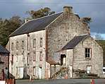
| Closeburn Mains (formerly Closeburn Hall Stables) |
|
|
|
55°12′59″N 3°43′03″W / 55.216462°N 3.71742°W / 55.216462; -3.71742 (Closeburn Mains (formerly Closeburn Hall Stables)) |
Category C(S) |
4009 |
 Upload another image
|
| Closeburn School |
|
|
|
55°12′49″N 3°43′41″W / 55.213535°N 3.728061°W / 55.213535; -3.728061 (Closeburn School) |
Category B |
4011 |
 Upload another image
|
| Kirkbog Farmhouse |
|
|
|
55°13′35″N 3°46′25″W / 55.226522°N 3.773719°W / 55.226522; -3.773719 (Kirkbog Farmhouse) |
Category C(S) |
3946 |
|
| Kirkland House |
|
|
|
55°13′07″N 3°45′45″W / 55.218622°N 3.762615°W / 55.218622; -3.762615 (Kirkland House) |
Category C(S) |
3947 |
|
| Wallacehall Assessment Centre (former Academy and Schoolhouse) |
|
|
|
55°12′49″N 3°43′35″W / 55.213684°N 3.726433°W / 55.213684; -3.726433 (Wallacehall Assessment Centre (former Academy and Schoolhouse)) |
Category A |
3953 |
|
| Gubhill Farmhouse |
|
|
|
55°12′47″N 3°37′00″W / 55.21305°N 3.616616°W / 55.21305; -3.616616 (Gubhill Farmhouse) |
Category C(S) |
3945 |
|
| Newton Farmhouse and Steading Range adjoining at South |
|
|
|
55°14′54″N 3°43′27″W / 55.24821°N 3.724122°W / 55.24821; -3.724122 (Newton Farmhouse and Steading Range adjoining at South) |
Category B |
3950 |
|
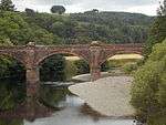
| Auldgirth Bridge |
|
|
|
55°09′34″N 3°42′35″W / 55.159492°N 3.709743°W / 55.159492; -3.709743 (Auldgirth Bridge) |
Category A |
3966 |
|
| Shotts Smithy |
|
|
|
55°12′13″N 3°42′53″W / 55.203613°N 3.714714°W / 55.203613; -3.714714 (Shotts Smithy) |
Category B |
3951 |
|
| Townpark |
|
|
|
55°13′04″N 3°43′07″W / 55.217776°N 3.718593°W / 55.217776; -3.718593 (Townpark) |
Category B |
3952 |
|
| Closeburn Castle |
|
|
|
55°12′41″N 3°43′06″W / 55.211363°N 3.718332°W / 55.211363; -3.718332 (Closeburn Castle) |
Category B |
4004 |
 Upload another image
|
| Closeburn Castle South Lodge and Gatepiers |
|
|
|
55°12′25″N 3°42′55″W / 55.206883°N 3.715405°W / 55.206883; -3.715405 (Closeburn Castle South Lodge and Gatepiers) |
Category B |
4006 |
|
| Rosebank |
|
|
|
55°13′35″N 3°46′08″W / 55.226314°N 3.768851°W / 55.226314; -3.768851 (Rosebank) |
Category B |
168 |
|
| Closeburn Castle Gatepiers (to East of Castle) |
|
|
|
55°12′42″N 3°43′01″W / 55.211661°N 3.71693°W / 55.211661; -3.71693 (Closeburn Castle Gatepiers (to East of Castle)) |
Category C(S) |
4005 |
|
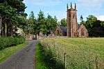
| Closeburn Old Church, Kirkpatrick of Closeburn Mausoleum and Churchyard Enclosure |
|
|
|
55°12′46″N 3°43′28″W / 55.212894°N 3.72445°W / 55.212894; -3.72445 (Closeburn Old Church, Kirkpatrick of Closeburn Mausoleum and Churchyard Enclosure) |
Category B |
4008 |
 Upload another image
|
| Dressertland Farm Roofed Midden |
|
|
|
55°13′42″N 3°43′17″W / 55.228289°N 3.721279°W / 55.228289; -3.721279 (Dressertland Farm Roofed Midden) |
Category B |
3944 |
|