List of listed buildings in Canonbie, Dumfries and Galloway
| Wikimedia Commons has media related to Canonbie. |
This is a list of listed buildings in the parish of Canonbie in Dumfries and Galloway, Scotland.
List
| Name | Location | Date Listed | Grid Ref. [note 1] | Geo-coordinates | Notes | HB Number [note 2] | Image |
|---|---|---|---|---|---|---|---|
| Canonbie Village, Canonbie War Memorial | 55°04′40″N 2°57′13″W / 55.07789°N 2.95357°W | Category C(S) | 3502 |  | |||
| Tarrasfoot Tile Works | 55°07′09″N 2°58′22″W / 55.119067°N 2.972676°W | Category A | 3535 |  | |||
| Barnglieshead Farm Steading | 55°05′51″N 3°03′40″W / 55.097625°N 3.060995°W | Category C(S) | 3536 | | |||
| Claygate Village, Claygate House and Gatepiers | 55°06′11″N 2°57′00″W / 55.103134°N 2.949986°W | Category C(S) | 3503 | | |||
| Byreburnfoot Bridge and Embankment (A7 over Byre Burn) | 55°05′33″N 2°57′25″W / 55.092403°N 2.956971°W | Category A | 3520 | | |||
| Canonbie Village, Schoolhouse | 55°04′51″N 2°56′50″W / 55.080841°N 2.947359°W | Category C(S) | 3501 | | |||
| Byreburn Bridge, (B6318 over Byre Burn) | 55°06′15″N 2°56′44″W / 55.104049°N 2.94551°W | Category C(S) | 3519 | | |||
| Penton Bridge (B6318 over the Liddel Water) | 55°05′17″N 2°53′25″W / 55.088111°N 2.890204°W | Category B | 3530 | 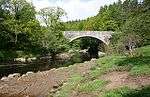 | |||
| Sark Bridge, (B6357 over River Sark) | 55°04′02″N 3°02′47″W / 55.06734°N 3.04646°W | Category B | 3534 | .jpg) | |||
| Canonbie Village School, Playground Walls and Railings | 55°04′49″N 2°56′49″W / 55.080403°N 2.947035°W | Category C(S) | 3500 | | |||
| Canonbie Free Church | 55°05′04″N 2°57′36″W / 55.084327°N 2.960021°W | Category B | 3521 | 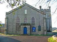 | |||
| Harelaw Limekilns | 55°06′02″N 2°53′59″W / 55.100433°N 2.899693°W | Category B | 3524 | | |||
| Hollows or Gilnockie Tower | 55°05′51″N 2°58′10″W / 55.097588°N 2.969491°W | Category A | 3527 | 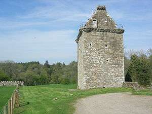 | |||
| Riddings Junction Viaduct over Liddel Water | 55°04′18″N 2°55′27″W / 55.071655°N 2.924183°W | Category A | 3533 | 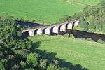 | |||
| Canonbie Village, Canonbie Parish Churchyard and Donaldson Monument (Priory Sedilia) | 55°04′40″N 2°56′57″W / 55.0777°N 2.949117°W | Category B | 3498 | 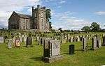 | |||
| Morton Churchyard (Sark Tower Churchyard) | 55°03′55″N 3°02′49″W / 55.065241°N 3.047079°W | Category B | 3528 | .jpg) | |||
| Canonbie Village, Canonbie Bridge (A7 over River Esk) | 55°04′47″N 2°56′55″W / 55.079698°N 2.948742°W | Category B | 3522 | 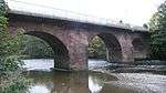 | |||
| Canonbie Village, Canonbie Parish Church | 55°04′40″N 2°56′57″W / 55.0777°N 2.949117°W | Category B | 3523 | | |||
| Old Tollbooth | 55°03′14″N 2°57′43″W / 55.053812°N 2.961952°W | Category B | 3529 | | |||
| Priorslynn, Cruck-framed Building | 55°04′24″N 2°57′04″W / 55.073262°N 2.951189°W | Category A | 3531 | | |||
| Brockwoodlees Farmhouse and Steading | 55°05′35″N 2°58′10″W / 55.09297°N 2.969379°W | Category B | 3537 | | |||
| Canonbie Free Church Manse | 55°05′03″N 2°57′37″W / 55.084099°N 2.960407°W | Category B | 3538 | | |||
| Uppermillsteads Farm Steading with Farmhouse and Well | 55°07′18″N 2°54′24″W / 55.121769°N 2.906649°W | Category C(S) | 49580 | | |||
| Glencartholm Farmhouse | 55°06′13″N 2°58′31″W / 55.103608°N 2.975185°W | Category B | 3505 | | |||
| Woodslee House | 55°03′33″N 2°57′18″W / 55.05907°N 2.954939°W | Category B | 3518 | | |||
| Priorslynn Farmhouse and Steading | 55°04′27″N 2°57′00″W / 55.074098°N 2.950034°W | Category B | 3532 | | |||
| Canonbie Village, Riverside Inn | 55°04′48″N 2°57′01″W / 55.079911°N 2.950203°W | Category B | 3499 | | |||
| Gilnockie Bridge (A7 over River Esk) | 55°05′39″N 2°57′50″W / 55.094154°N 2.96397°W | Category A | 3504 | .jpg) | |||
| Hollows Mill | 55°05′42″N 2°57′53″W / 55.095003°N 2.964617°W | Category B | 3525 | | |||
| Hollows Mill, Farm Steading | 55°05′43″N 2°57′55″W / 55.09516°N 2.965232°W | Category B | 3526 | |
Key
The scheme for classifying buildings in Scotland is:
- Category A: "buildings of national or international importance, either architectural or historic; or fine, little-altered examples of some particular period, style or building type."[1]
- Category B: "buildings of regional or more than local importance; or major examples of some particular period, style or building type, which may have been altered."[1]
- Category C: "buildings of local importance; lesser examples of any period, style, or building type, as originally constructed or moderately altered; and simple traditional buildings which group well with other listed buildings."[1]
In March 2016 there were 47,288 listed buildings in Scotland. Of these, 8 per cent were Category A, and 50 per cent were Category B, with the rest listed at Category C.[2]
Notes
- ↑ Sometimes known as OSGB36, the grid reference (where provided) is based on the British national grid reference system used by the Ordnance Survey.
• "Guide to National Grid". Ordnance Survey. Retrieved 2007-12-12.
• "Get-a-map". Ordnance Survey. Retrieved 2007-12-17. - ↑ The "HB Number" is a unique number assigned to each listed building by Historic Environment Scotland.
References
- All entries, addresses and coordinates are based on data from Historic Scotland. This data falls under the Open Government Licence
- 1 2 3 "What is Listing?". Historic Environment Scotland. Retrieved 29 May 2018.
- ↑ Scotland's Historic Environment Audit 2016 (PDF). Historic Environment Scotland and the Built Environment Forum Scotland. pp. 15–16. Retrieved 29 May 2018.
This article is issued from
Wikipedia.
The text is licensed under Creative Commons - Attribution - Sharealike.
Additional terms may apply for the media files.