Lhatse County
| Lhazê County 拉孜县 • ལྷ་རྩེ་རྫོང་། | |
|---|---|
| County | |
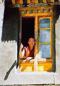 Old Lhatse Monastery | |
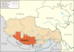
.png) Location of Lhatse County (red) within Xigazê City (yellow) and Tibet | |
 Lhatse Location of the seat in Tibet | |
| Coordinates: 29°11′15″N 88°05′34″E / 29.18750°N 88.09278°ECoordinates: 29°11′15″N 88°05′34″E / 29.18750°N 88.09278°E | |
| Country | People's Republic of China |
| Autonomous region | Tibet |
| Prefecture-level city | Xigazê |
| Seat | Lhatse |
| Time zone | UTC+8 (China Standard) |
| Lhatse County | |||||||||||
| Chinese name | |||||||||||
|---|---|---|---|---|---|---|---|---|---|---|---|
| Simplified Chinese | 拉孜县 | ||||||||||
| Traditional Chinese | 拉孜縣 | ||||||||||
| |||||||||||
| Tibetan name | |||||||||||
| Tibetan | ལྷ་རྩེ་རྫོང་། | ||||||||||
| |||||||||||
Lhatse County is a county of Xigazê in the Tibet Autonomous Region. It was established in 1959, with Lhatse Town as the county seat. In 1968, Quxia Town became the county seat.[1]
Lhatse County, has a population of some 50,000 and is about 200 kilometers from Mount Everest (or Chomolungma). It is among the most impoverished counties in China.[2]
Geography
Towns and townships
- Lhazê Town (ལྷ་རྩེ་, 拉孜镇)
- Quxar Town (ཆུ་ཤར་, 曲下镇)
- Tashi Dzom Township (བཀྲ་ཤིས་འཛོམས་, 扎西宗乡)
- Qoima Township (ཆོས་མ་, 曲玛乡)
- Püncogling Township (ཕུན་ཚོགས་གླིང་, 彭措林乡)
- Tashigang Township (བཀྲ་ཤིས་སྒང་, 扎西岗乡)
- Liu Township (སླེའུ་, 柳乡)
- Resa Township (རེ་ས་, 热萨乡)
- Mangpu Township (མང་ཕུ་, 芒普乡)
- Xiqên Township (གཞིས་ཆེན་, 锡钦乡)
- Chau Township (གྲའུ་, 查务乡)
- 482 natural villages [1]
Transport
References
- 1 2 "Lhatse, Lhatse County – Lhatse Trip". China Travel Blogs – Tour-Beijing.com. 2011-09-01. Retrieved 2013-10-20.
- ↑ "Move to hospital deliveries saves mothers, infants in Tibet." Xinhua Writers Bai Xu and Hu Xing. 25 Feb. 2009
| County-level divisions |
|  | ||||
|---|---|---|---|---|---|---|
| Settlements | ||||||
| Landmarks | ||||||
| Geography | ||||||
| Transport |
| |||||
This article is issued from
Wikipedia.
The text is licensed under Creative Commons - Attribution - Sharealike.
Additional terms may apply for the media files.