Leilani Estates, Hawaii
| Leilani Estates, Hawaii | ||
|---|---|---|
| Census-designated place | ||
|
| ||
| Coordinates: 19°28′25″N 154°55′13″W / 19.47361°N 154.92028°WCoordinates: 19°28′25″N 154°55′13″W / 19.47361°N 154.92028°W | ||
| Country | United States | |
| State | Hawaii | |
| County | Hawaiʻi | |
| Area | ||
| • Total | 4.1 sq mi (10.5 km2) | |
| • Land | 4.1 sq mi (10.5 km2) | |
| • Water | 0.0 sq mi (0.0 km2) | |
| Elevation | 771 ft (235 m) | |
| Population (2010) | ||
| • Total | 1,560 | |
| • Density | 387/sq mi (149.3/km2) | |
| Time zone | UTC-10 (Hawaii-Aleutian Standard Time Zone) | |
| Area code(s) | 808 | |
| FIPS code | 15-44562 | |
| GNIS feature ID | 1852580 | |
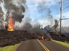
Leilani Estates is a census-designated place (CDP) in Hawaiʻi County, Hawaii, United States located in the District of Puna. The subdivision was formed in 1964.[1] The population was 1,560 at the 2010 census,[2] up from 1,046 at the 2000 census. On May 4, 2018 the subdivision was under voluntary evacuation due to an outbreak of numerous lava vents along the lower East Rift Zone of Kīlauea volcano. By May 6 the count of homes destroyed by lava reached 26.[3] By May 9, the loss of another home raised the count to 27.[4] After more homes were destroyed, a mandatory evacuation was ordered by Hawaiʻi Civil Defense by June 1 of all residents from Pomaikai Street eastward, with people found in the area after that date subject to arrest.[5]
Geography
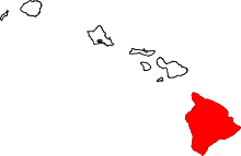
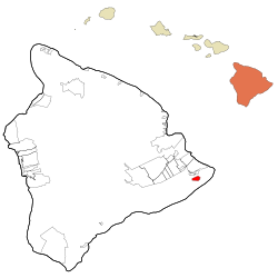
Leilani Estates is located near the eastern tip of the island of Hawaii.[6] It is 3 miles (5 km) south of Pāhoa and 23 miles (37 km) south of Hilo. It is bordered to the southeast by the Malama Kī Forest Reserve.
According to the United States Census Bureau, the CDP has a total area of 4.03 square miles (10.45 km2), all of it land.[2]
Leilani Estates is located directly on a stretch of the lower East Rift Zone of Kīlauea volcano, in lava flow hazard zone 1.[7] Zone 1 includes the summit and rift zones of active volcanoes—new eruptive vents can spawn anywhere inside this zone. Approximately 10% or 50 square miles (100 km2) out of the 500 square miles (1,000 km2) of Puna have been covered by lava flows since 1790.[8]
2018 eruption
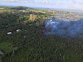
On May 3, 2018, a fissure opened in Leilani Estates, resulting in lava fountaining up to 150 feet (50 m) in the air and spreading over an area 200 yards (200 m) wide.[9] All inhabitants of Leilani Estates were ordered to evacuate the subdivision.[10] By May 6 Hawaiʻi County Civil Defence reported that 26 houses in the subdivision had been destroyed after eruptions occurred from 14 separate vents along the rift. By May 9, the destruction of an additional home raised the count to 27.[4] The rift is a fault in the volcano's structure that runs deep underground, and from the volcano's summit into the sea. The eruption continued until early August, and continued to claim more homes in the subdivision[11][12] and beyond it.
Demographics
As of the census of 2010, there were 1,560 people in 696 households residing in the CDP. The population density was 371.4 people per square mile (144.4/km²). There were 807 housing units at an average density of 192.1 per square mile (74.7/km²). The racial makeup of the CDP was 63.4% White, 1.4% African American, 1.8% American Indian & Alaska Native, 6.1% Asian, 6.2% Native Hawaiian & Pacific Islander, 1.2% from other races, and 20.0% from two or more races. Hispanic or Latino of any race were 9.8% of the population.[13]
There were 696 households out of which 18.1% had children under the age of 18 living with them. The average household size was 2.24.[13]
In the Leilani Estates CDP the population was spread out with 17.4% under the age of 18, 6.9% from 18 to 24, 11.7% from 25 to 34, 17.6% from 35 to 49, 32.9% from 50 to 64, and 13.4% who were 65 years of age or older. For every 100 females, there were 113.1 males. For every 100 males there were 88.4 females.[13]
The median income for a household in the CDP at the 2000 census was $31,540, and the median income for a family in 2000 was $32,692. Males had a median income of $30,500 versus $22,875 for females in 2000. The per capita income for the CDP in 2000 was $15,522. About 13.7% of families and 21.9% of the population were below the poverty line in 2000, including 16.4% of those under age 18 and 25.5% of those age 65 or over.
References
- ↑ "Chapter "Leilani Estates History" at leilaniestates.org". Retrieved May 31, 2018.
- 1 2 "Geographic Identifiers: 2010 Demographic Profile Data (G001): Leilani Estates CDP, Hawaii". American Factfinder. U.S. Census Bureau. Retrieved June 1, 2017.
- ↑ "Gov. David Ige to meet with officials on Hawaii island over volcano relief". 6 May 2018. Retrieved 8 May 2018.
- 1 2 "New vents destroy another Leilani Estates home". Honolulu Star-Advertiser. 9 May 2018. Retrieved 9 May 2018.
- ↑ http://www.staradvertiser.com/2018/06/01/hawaii-news/leilani-estates-lava-might-not-be-part-of-the-eruption-that-began-in-1983-scientists-say/
- ↑ "US Gazetteer files: 2010, 2000, and 1990". United States Census Bureau. 2011-02-12. Retrieved 2011-04-23.
- ↑ Wright, T.L.; Chun, J.Y.F.; Exposo, Jean; Heliker, Christina; Hodge, Jon; Lockwood, J.P.; Vogt, S.M. (1992). "Map Showing Lava-Flow Hazard Zones, Island of Hawaii". USGS Pubs Warehouse. U.S. Geological Survey. Retrieved 2017-12-30.
- ↑ Program, Volcano Hazards. "USGS: Volcano Hazards Program HVO Kilauea". hvo.wr.usgs.gov. Retrieved 8 May 2018.
- ↑ "Overnight, earthquakes and lava become the new norm on Hawaii island". 3 May 2018. Retrieved 8 May 2018.
- ↑ "Nine Leilani Estates homes destroyed; lava fountains reach as high as 230 feet". 4 May 2018. Retrieved 8 May 2018.
- ↑ Hawaii County Civil Defense,"East Rift Zone Eruption WED,7/11/18,12PM"
- ↑ "Lava destroys 3 more homes in Leilani Estates". Honolulu Star Advertiser. 11 July 2018. Retrieved 11 July 2018.
- 1 2 3 ASD, Website Services & Coordination Staff,. "2010 Demographic Profile - U.S. Census Bureau". www.census.gov. Retrieved 8 May 2018.