Lauriston, Victoria
| Lauriston Victoria | |||||||||||||||
|---|---|---|---|---|---|---|---|---|---|---|---|---|---|---|---|
 Lauriston Road | |||||||||||||||
 Lauriston | |||||||||||||||
| Coordinates | 37°15′S 144°23′E / 37.250°S 144.383°ECoordinates: 37°15′S 144°23′E / 37.250°S 144.383°E | ||||||||||||||
| Population | 295 (2011 census)[1] | ||||||||||||||
| Postcode(s) | 3444 | ||||||||||||||
| Location | |||||||||||||||
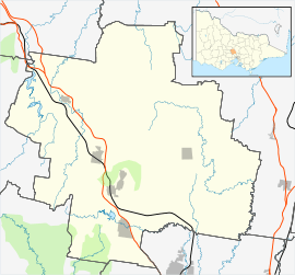
| LGA(s) | Shire of Macedon Ranges | ||||||||||||||
| State electorate(s) | Macedon | ||||||||||||||
| Federal Division(s) | Bendigo | ||||||||||||||
| |||||||||||||||
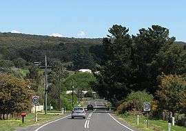
Lauriston is a small community in Victoria, Australia. It is situated on the Coliban River, in a gully 8 kilometres (5 mi) west of Kyneton. The Lauriston Reservoir, (which serves Kyneton), is 2 kilometres (1 mi) south east of the town.
At the 2011 census, Lauriston had a population of 295.[1]
Lauriston Post Office opened on 1 July 1864 after gold was discovered in the area and closed in 1969.[2]
References
- 1 2 Australian Bureau of Statistics (31 October 2012). "Lauriston (State Suburb)". 2011 Census QuickStats. Retrieved 9 December 2014.

- ↑ Premier Postal History, Post Office List, retrieved 2008-04-11
External links
![]()
This article is issued from
Wikipedia.
The text is licensed under Creative Commons - Attribution - Sharealike.
Additional terms may apply for the media files.