La Magdeleine
| La Magdeleine | ||
|---|---|---|
| Comune | ||
|
Comune di La Magdeleine Commune de La Magdeleine | ||
| ||
 La Magdeleine Location of La Magdeleine in Italy | ||
| Coordinates: 45°49′N 7°37′E / 45.817°N 7.617°ECoordinates: 45°49′N 7°37′E / 45.817°N 7.617°E | ||
| Country | Italy | |
| Region | Aosta Valley | |
| Province | none | |
| Frazioni | Artaz, Brengon, Clou, Messelod, Vieu | |
| Area | ||
| • Total | 8 km2 (3 sq mi) | |
| Elevation | 1,644 m (5,394 ft) | |
| Population (31 December 2006) | ||
| • Total | 100 | |
| • Density | 13/km2 (32/sq mi) | |
| Time zone | UTC+1 (CET) | |
| • Summer (DST) | UTC+2 (CEST) | |
| Postal code | 11020 | |
| Dialing code | 0166 | |
| Saint day | 23 July | |
| Website | Official website | |
.svg.png)
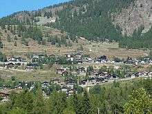
La Magdeleine (Valdôtain: La Madéléna) is a town and comune in the Aosta Valley region of north-west Italy. La Magdeleine is a small ski resort featuring easy slopes, a nordic ski touring route and a snow park for children. It is also a launching base for hand-glider flights. At an altitude of 1644 metres, it is located on the left bank of the Marmore river, in the middle of the Cervino Valley. This mountain settlement in the Aosta Valley is the old centre in the hamlet of Vieu. The town features eight mills, powered by water from a small river, whose origins date back to the XVIII century. La Magdeleine is home to many chapels, including one built in the 1600s which is dedicated to San Rocco, in the hamlet of Messelod. Paleontological remains found at a height of more than 2000 metres (on the slopes of Monte Tantané) suggest that this area was populated during the first Iron Age. In Medieval times, La Magdeleine was part of the Cly Dominion and was economically linked to Châtillon.[1]
References
