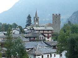
Champorcher
| Champorcher | ||
|---|---|---|
| Comune | ||
|
Comune di Champorcher Commune de Champorcher | ||
 | ||
| ||
 Champorcher Location of Champorcher in Italy | ||
| Coordinates: 45°37′N 7°37′E / 45.617°N 7.617°E | ||
| Country | Italy | |
| Region | Aosta Valley | |
| Frazioni | Boussiney, Perrier, Dogier, Dublanc, Salleret, Outre l’éve, Parié, Moulin, L’Écreux, Véranaz, Loré, Vigneroisaz, Vagly, Mellier, Coudreyt, Grand-Rosier, Petit-Rosier, Château, Gontier, Garavet, Byron, Arbussey, Collin, Grand-Mont-Blanc, Petit-Mont-Blanc, Perruchon, Ronchas, Chardonney, Sen-du-Gail, Vignat | |
| Government | ||
| • Mayor | Celestino Savin | |
| Area | ||
| • Total | 68 km2 (26 sq mi) | |
| Elevation | 1,427 m (4,682 ft) | |
| Population (January 2017) | ||
| • Total | 394[1] | |
| Demonym(s) | Champorchereins | |
| Time zone | UTC+1 (CET) | |
| • Summer (DST) | UTC+2 (CEST) | |
| Postal code | 11020 | |
| Dialing code | 0125 | |
| Patron saint | Saint Nicholas | |
| Saint day | 6 December | |
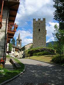
the Castle
Champorcher (Arpitan: Tsamportsé, lit. 'field of Porcius'[2]) is a comune in the Aosta Valley region of northwestern Italy, the main town in the Champorcher Valley.
References
- ↑ Bilancio demografico anno 2017 (dati provvisori) Comune: Champorcher, demo.istat.it
- ↑ A Roman Catholic saint, according to the legend one of the matyrs of the Theban Legion.
External links
- Champorcher, lovevda.it
- Scuola di Sci Champorcher, lovevda.it

This article is issued from
Wikipedia.
The text is licensed under Creative Commons - Attribution - Sharealike.
Additional terms may apply for the media files.