Etroubles
| Étroubles | ||
|---|---|---|
| Comune | ||
|
Comune di Étroubles Commune d'Étroubles | ||
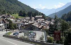 View of Étroubles | ||
| ||
 Étroubles Location of Étroubles in Italy | ||
| Coordinates: 45°49′N 7°13′E / 45.817°N 7.217°ECoordinates: 45°49′N 7°13′E / 45.817°N 7.217°E | ||
| Country | Italy | |
| Region | Aosta Valley | |
| Province | None | |
| Frazioni | Bézet, Chez-les-Blancs, Cerisey, Échevennoz, Éternod, La Collère, Lavanche, Pallais, Prailles, Vachéry, Véyaz | |
| Government | ||
| • Mayor | Massimo Tamone | |
| Area | ||
| • Total | 39 km2 (15 sq mi) | |
| Elevation | 1,280 m (4,200 ft) | |
| Population (31 December 2010) | ||
| • Total | 491 | |
| • Density | 13/km2 (33/sq mi) | |
| Demonym(s) | Étroubleins | |
| Time zone | UTC+1 (CET) | |
| • Summer (DST) | UTC+2 (CEST) | |
| Postal code | 11014 | |
| Dialing code | 0165 | |
| Website | Official website | |
.svg.png)

the Parish Church
Étroubles (Valdôtain: Étroble) is a town and comune in the Aosta Valley region of northwestern Italy.
Sights include a bell tower from a now disappeared 15th century Romanesque church and a medieval watchtower (built in the 12th century on Roman foundings.
History
In Roman times, it was known as Restapolis and was the main center in the Grand-Saint-Bernard Valley. It perhaps housed the local garrison watching the main access from Gaul. In medieval times, it was a stage on the Via Francigena.
Napoleon Bonaparte stayed at Étroubles on 20 May 1800, during his march to Marengo and the eponymous battle.

This article is issued from
Wikipedia.
The text is licensed under Creative Commons - Attribution - Sharealike.
Additional terms may apply for the media files.