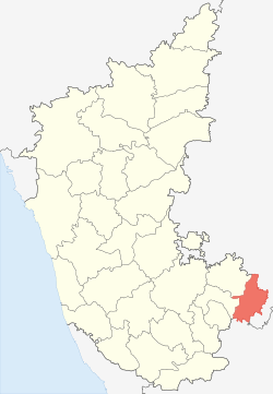
Kolar district
| Kolar district | |
|---|---|
| District | |
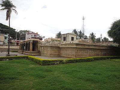
.JPG) Someshwara Temple in Kolar | |
 | |
| Country | India |
| State | Karnataka |
| Division | Bangalore |
| Headquarters | Kolar |
| Area† | |
| • Total | 4,012 km2 (1,549 sq mi) |
| Population (2011)† | |
| • Total | 1,540,231 |
| • Density | 384/km2 (990/sq mi) |
| Languages | |
| • Official | Kannada |
| Time zone | UTC+5:30 (IST) |
| ISO 3166 code | IN-KA-KL |
| Vehicle registration | KA-07, KA-08 |
| Sex ratio | 0.976 ♂/♀ |
| Literacy | 74.33% |
| Lok Sabha constituency | Kolar Lok Sabha constituency |
| Precipitation | 724 millimetres (28.5 in) |
| Website |
kolar |
| † Kolar district at a glance | |
Kolar district ![]()
On 10 September 2007, it was bifurcated to form the new district of Chikballapur.[1] Due to the discovery of the Kolar Gold Fields, the district has become known as the "Golden Land" of India.
History
_at_Kolar.JPG)
_in_Someshvara_Temple_at_Kolar.JPG)
_at_Avani.JPG)
.JPG)
Kolar, formerly known as Kolahala, Kuvalala and Kolala, was called Kolahalapura during the Middle Ages. In Kannada, kolahahapura means "violent city" and it was the battlefield for the warring Chalukyas in the north and the Cholas in the south. In 1004 AD, the Cholas annexed Kolar until 1116. Vishnuvardhana (1108-1142) freed Gangavadi from the Cholas and, to commemorate his victory, built the Chennakesava Temple at Belur.
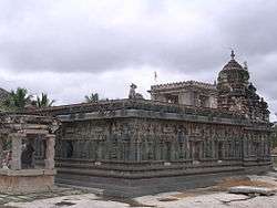
Kolaramma and Someshwara are notable temples in Kolar. The Kolaramma temple, built in Dravida Vimana style during the secondnd century, is dedicated to Shakti. It underwent renovations under Rajendra Chola I in the 10th century and the Vijayanagara kings in the 15th century.[2][3] Someswara Temple is an example of 14th-century Vijayanagara art.
Kolar's early history was compiled by Fred Goodwill, superintendent of the Wesleyan Tamil mission in Bangalore and the Kolar Gold Fields, and his studies have been published in a number of journals.[4][5][6] Older than Bangalore, Kolar dates back to the second century. The Western Gangas made Kolar their capital, ruling Mysore, Coimbatore, Salem and Travancore. During the 13th century Bhavanandi composed Nannool, his treatise on Tamil grammar.
Under the Cholas, King Sridhar kora (ruled 970–985) reportedly built the temple for Renuka and founded the city of Kolaahalapuram. Veera Chola, Vikrama Chola and Rajendra Chola I built stone structures with inscriptions at Avani, Mulbagal, Sitti Bettta and elsewhere. Chola inscriptions, which document the rule of Adithya Chola I (871-907), Raja Raja Chola I and Rajendra Chola I of Kolar, refer to Kolar as Nikarili Cholamandalam and Jayam Konda Chola Manadalam. Inscriptions from Rajendra Chola I also appear on the Kolaramma Temple. Many Siva temples were built in Kolar during the reign of the Cholas, including the Someshwarar and Sri Uddhandeshwari Temples at Maarikuppam Village, the Eswaran Temple at Oorugaumpet and the Sivan Temple at Madivala Village. Chola rule of Kolar lasted until 1116. The inscriptions are neglected, and some have been vandalised.
In 1117 Kolar became part of the Hoysala Empire; in 1254 it was bestowed to Ramanatha, one of King Someshwara's two sons. The Hoysala were defeated by the Vijayanagara Empire, which ruled Kolar from 1336 to 1664. During this period, the Sri Someshwara Temple at Kolar was built.
For 50 years in the 17th century Kolar was under Maratha rule as part of the Jagir of Shahaji, followed by 70 years of Muslim rule. In 1720 it became part of the Province of Sira, with Fateh Mohammed (the father of Hyder Ali) the province's Faujdar. Kolar was then ruled by the Marathas, the Nawab of Cuddapah, the Nizam of Hyderabad and Hyder Ali. It was under British rule from 1768 to 1770 before a brief Maratha rule followed by Hyder Ali. In 1791 Lord Cornwallis conquered Kolar and returned it to the Kingdom of Mysore in the peace treaty of 1792.
In the Kolar region, inscriptions document the reigns of the Mahavalis (Baanaas), the Pallavas and the Vaidumbaas.[4][5][6][7][8] Benjamin Lewis Rice recorded 1,347 inscriptions in the Kolar District, in the 10th volume of his Epigraphia Carnatica. Of the inscriptions, 422 are in Tamil, 211 in Telugu and the remainder in Kannada.[9]
Geography
Kolar district is in a semi-arid, drought-prone region and covers an area of 8,225 square kilometres (3,176 sq mi). It stretches about 135 kilometres (84 mi) north to south and almost the same distance east to west. The district occupies the tableland of Mysore, bordering the Eastern Ghats. The plateau is interrupted by a hills and mountains of varying heights, particularly in the north. The Nandi Hills run north from Nandi towards Penukonda and Dharmavaram in Andhra Pradesh. Rivers are small and seasonal; the Palar, Uttara Pinakini and Dakshina Pinakini originate in the highlands. Borewel has reached level of 2000 ft. Water is contaminated from fluoride. People are fighting for drinking water. A protest 'Shashwata NEERAVARI HORATA' -people initiative is started before 250 days and still going on.
Taluks
Economy
The major sources of employment are agricultural: dairy farming, sericulture and floriculture. The district is popularly known as the land of "silk, milk and gold". Farmers in Kolar depend on borewell water for irrigation and drinking. The Kolar Gold Fields were closed in 2003 due to shrinking gold deposits and increasing production costs.
Industry and markets
Honda received incentives from the state government to manufacture motorcycles in the district and it becomes the World's largest two wheeler manufacturing plant and also consists of major industries like Scania commercial vehicles India Pvt Ltd, Mahindra Aerospace, Glaxo Smith Kline(GSK) pharmaceutical company, Tata Power, Mitsubishi Electric, Cerebra e-waste recycler plant, Prakash Buses and many more ref>Honda Unit at Narasapura, Kolar</ref>[10] Power Grid Corporation of India has a substation at Arahalli Village in Kolar.[11] There is a tomato market in Mulbagal, a silk and vegetable market in Kolar, a mango market in Srinivaspura and jewellery shops at the Kolar Gold Fields. Realtors Paratus BuildCon Pvt.Ltd aggressively developing layouts near Narsapura.Bharath Earth Movers Limited(BEML) has their plant at Kolar Gold Fileds.
Transport
Road
National Highway 75 (old NH-4) passes through Narasapura, Kolar and Mulbagal, and a state highway and district roads connect other taluks. NH-75 connects Bangalore, Narasapura, Kolar, Mulbagal, Chittor, Vellore, Katpadi and Chennai, with connection to Thirupathi. Bangalore is about a 90-minute drive from Mulbagal.[12]
| Sl No | Kolar district | National highway | State highway | District road | Total length |
|---|---|---|---|---|---|
| 01 | Entire district | 137 | 308 | 1083 | 1528 |
| 02 | Mulbagilu | 68 | 0 | 354 | 422 |
| 03 | Malur | 8 | 68 | 94 | 170 |
| 04 | Bangarpet | 0 | 77 | 201 | 278 |
| 05 | Srinivaspura | 30 | 72 | 217 | 319 |
Rail
Kolar is in the South Western Railway zone of Indian Railways. The district has junctions at Kolar and Bangarapet and Kolar Gold Fields itself consists of five stations, namely BEML nagar, Coromandel, Oorgaum, Champion Reef, Marikuppam and other stations at Malur, Bisanattam, Byatrayana Halli, Kamasamudram, Makali Durg, Srinivaspura, and Tyakal. They are on the Chennai-Bangalore main line or its branch line. Bangarpet Junction is one of the busiest railway line in SWR division.[14]
Demographics
| Population growth | |||
|---|---|---|---|
| Census | Pop. | %± | |
| 1901 | 392,651 | — | |
| 1911 | 429,193 | 9.3% | |
| 1921 | 436,066 | 1.6% | |
| 1931 | 469,811 | 7.7% | |
| 1941 | 555,545 | 18.2% | |
| 1951 | 650,807 | 17.1% | |
| 1961 | 721,822 | 10.9% | |
| 1971 | 826,563 | 14.5% | |
| 1981 | 1,044,394 | 26.4% | |
| 1991 | 1,211,858 | 16.0% | |
| 2001 | 1,387,062 | 14.5% | |
| Est. 2010 | 1,571,700 | 13.3% | |
| Source: District website[15] | |||
In the 2011 census, the district had a population of 1,540,231[16]—roughly equal to that of Gabon[17] or Hawaii.[18] It ranked 324th of India's 640 districts).[16] The district has a population density of 384 inhabitants per square kilometre (990/sq mi),[16] with a growth rate of 11.04 percent from 2001 to 2011.[16] Kolar's sex ratio is 976 females per 1,000 males.[16] Its literacy rate is 74.33 percent.[16] The district has 15 towns and a total of 3,321 villages (2,889 inhabited villages and 432 uninhabited).
Culture
The district's primary language is Kannada; Urdu, Tamil and Telugu are also spoken. Kolar Gold Fields (KGF) has an Anglo-Indian population. Festivals include the 13-day summer Karaga, celebrated in Malur and usually beginning the first Friday after Ugadi; the water festival Theppothsava, and Dyavara.
Attractions
Kolar
- Antara Gange
- Kolaramma Temple and Someshwara Temple
- Hyder Ali Parents tomb
- Clock tower & Kutubsha DARGHA
- Markandeya Hill
- Therhalli
8 BYPANAHALLI{{{{DEFAULTSORT:}}}}
Bangarapet
- Budikote
- Bethamangala
- Kotilingeshwara
- Bytarayappana Bett
- chitnahalli
Malur
- Chikka Tirupati
- Dharmaraya Swamy Temple
- Marikamba temple
Mulbagal
- Baba Hyder-e-Safdar DARGHA
- Byrakur
- gokunte
- Kurudumale
- Avani
- gudipalli Someshwara Temple
Notable residents
- Hyder Ali - father of Tipu Sultan
- D. V. Gundappa - Kannada poet
- K. C. Reddy - first Chief Minister of Karnataka
- Maasti Venkatesh Ayengar - Kannada writer and Jnanpith Award recipient
- K. H. Muniyappa - Union Minister of state for Indian Railways; represents Kolar in the Parliament of India for a sixth term.
- N. R. Narayana Murthy - Chairman and Chief Mentor of Infosys Technologies Limited
- Soundarya - South Indian film actress
- A. N. Prahlada Rao - author and crossword
- GOPALAPPA - International Kabaddi player
- [ [KR Ramesh kumar K,R ] ] Health Minister
- [ [KR Ramesh Kumar ] ] Speaker of karnataka Vidhana parishath
- [ [ Famous Mango City in SrinivasPura ]]
Education
- Dr.T.Thimmaiah Institute of Technology, Oorgaum post, KGF, Kolar-563120
- Global Public School Nisar Nagar, Kolar
- Sahyadri pu and degree college tekalroad kolar .C Byregowda Institute of Technology, Kolar-Srinivaspur Road, Kolar
- Sri Devaraj Urs Medical College, Kolar
- Government Law College, Kolar
- Government College for Boys, Kolar
- Government PU College for Boys, Srnivasapura, Kolar
- Government College for Women, Kolar
- Sri Devaraj Urs School of Nursing, Kolar
- Seventh Day Adventist High School, Kolar
- Mahila Samaja PU and degree college, Kolar
- St Anne's Convent High School, Kolar
- St. Joseph's Convent, Champion Reefs, KGF
- St. Mary's High School, Champion Reefs, KGF
- Parkinson Memorial School, KGF
- Sri Bhagawan Mahaveer Jain College, KGF
- Suvarna Central School, Kolar
- Sambhram Institute Of Medical Sciences And Research, D.K. Plantation, BEML Nagar, Kolar Gold Fields, Karnataka– 563115.
Media
See also
References
- ↑ "A Handbook of Karnataka - Administration" (PDF). Government of Karnataka. pp. 354, 355. Archived from the original (pdf) on 8 October 2011. Retrieved 16 November 2010.
- ↑ "A green view". The Hindu. Chennai, India. 11 March 2006. Retrieved 23 December 2010.
- ↑ "Temples of Karnataka - Kolar". templenet.com. Retrieved 23 December 2010.
- 1 2 Mythic Society (Bangalore, India) (1918). The Quarterly Journal of the Mythic Society. 9–10: iv, 5, 8, 300. Missing or empty
|title=(help) - 1 2 Goodwill, Fred (1918). "Nandidroog". The Quarterly Journal of the Mythic Society. 9–10: 300. Retrieved 27 August 2014.
- 1 2 Goodwill, Fred (1921). "The Religious and Military Story of Nudydurga". KGF Mining and Metallurgical Society (5).
- ↑ Srikumar, S (2014). Kolar Gold Field: (Unfolding the Untold) (International ed.). Partridge India. pp. 40–46. ISBN 9781482815078. Retrieved 27 August 2014.
- ↑ Chandrashekar, Gayatri (2015). Grit and Gold. Partridge Publishing. ISBN 9781482855845. Retrieved 11 July 2016.
- ↑ Rice, Benjamin Lewis (1994). Epigraphia Carnatica: Volume X: Inscriptions in the Kolar District. Mangalore, British India: Department of Archeology, Mysore State. p. i. Retrieved 4 August 2015.
- ↑ "Karnataka showers Honda with concessions - The Times of India". The Times Of India.
- ↑ Power Grid , Kolar
- ↑ Bangalore-Mulbagal Road (NH-75)Mulbagal
- ↑ Kolar Roads
- ↑
- ↑ "Kolar district at a glance" (PDF). Archived from the original (pdf) on 12 March 2011. Retrieved 22 December 2010.
- 1 2 3 4 5 6 "District Census 2011". Census2011.co.in. 2011. Retrieved 2011-09-30.
- ↑ US Directorate of Intelligence. "Country Comparison:Population". Retrieved 2011-10-01.
Gabon 1,576,665
- ↑ "2010 Resident Population Data". U. S. Census Bureau. Archived from the original on 23 August 2011. Retrieved 2011-09-30.
Hawaii 1,360,301
- ↑ Kolaravani
- ↑ Kannada Thilaka
External links
| Wikimedia Commons has media related to Kolar district. |