Kirchberg, Saxony
| Kirchberg | ||
|---|---|---|
| ||
 Kirchberg Location of Kirchberg within Zwickau district 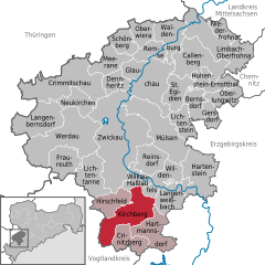  | ||
| Coordinates: 50°37′20″N 12°31′32″E / 50.62222°N 12.52556°ECoordinates: 50°37′20″N 12°31′32″E / 50.62222°N 12.52556°E | ||
| Country | Germany | |
| State | Saxony | |
| District | Zwickau | |
| Government | ||
| • Mayor | Dorothee Obst | |
| Area | ||
| • Total | 39.58 km2 (15.28 sq mi) | |
| Elevation | 349 m (1,145 ft) | |
| Population (2017-12-31)[1] | ||
| • Total | 8,317 | |
| • Density | 210/km2 (540/sq mi) | |
| Time zone | CET/CEST (UTC+1/+2) | |
| Postal codes | 08107 | |
| Dialling codes | 37602 | |
| Vehicle registration | Z | |
| Website | www.kirchberg.de | |

Kirchberg is a town in the Zwickau district, in the Free State of Saxony, Germany. It is situated at the western end of the Ore Mountains, 11 km south of Zwickau.
.jpg)
Panorama of Kirchberg
Sons and daughters of the city
- Christoph Graupner (1683-1760), musician and composer. The high school in Kirchberg is named after him.
- Robert Seidel (1850-1933), politician, took part in the founding congress of the SPD. There is a street named after him in Kirchberg.
See also

References
- ↑ "Aktuelle Einwohnerzahlen nach Gemeinden 2017] (Einwohnerzahlen auf Grundlage des Zensus 2011)" (PDF). Statistisches Landesamt des Freistaates Sachsen (in German). October 2018.
This article is issued from
Wikipedia.
The text is licensed under Creative Commons - Attribution - Sharealike.
Additional terms may apply for the media files.