Kingswood, South Gloucestershire
| Kingswood | |
|---|---|
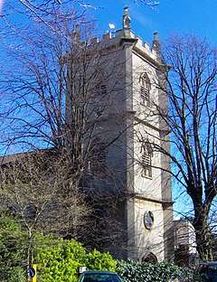 Holy Trinity church | |
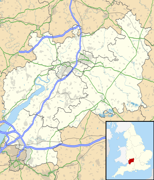 Kingswood Kingswood shown within Gloucestershire | |
| Population | 40,734 (2011 Census) |
| OS grid reference | ST649736 |
| Unitary authority | |
| Ceremonial county | |
| Region | |
| Country | England |
| Sovereign state | United Kingdom |
| Post town | BRISTOL |
| Postcode district | BS15 |
| Dialling code | 0117 |
| Police | Avon and Somerset |
| Fire | Avon |
| Ambulance | South Western |
| EU Parliament | South West England |
| UK Parliament | |
Kingswood is a town in South Gloucestershire, England, on the eastern border of the City of Bristol. The suburb is situated 3.4 miles (5.5 km) east-northeast of Bristol City Centre and 102 miles (164 km) west of London.[1][2]
Royal Forest
In Saxon and Norman times, Kingswood Forest was a royal hunting estate which surrounded Bristol, extending as far as Filwood in South Bristol. "From early days the Constable of Bristol Castle, the king's officer in the area, was also the Chief Ranger of the Kingswood Forest and the first of these recorded is Ella who died in 920. At the edge of the forest, to the north of the River Froom, lay the little hamlet of Stapleton, the name of which is Saxon in origin, being held to mean 'The farm, homestead or croft – by or near the Stapol, post or pillar'".[3]
Demography
Kingswood town and Staple Hill are the only areas that are unparished (an area that doesn't have an incorporated town council on its own) in South Gloucestershire. Furthermore Kingswood is considered by ONS as part of Bristol, being within its urban subdivision.[4] This makes Kingwood statistically and administratively an informal settlement, being unparished and part of a larger urban subdivision, parliament constituency and district with all three divisions containing other areas. Hence its population is taken from four ward boundaries in South Gloucestershire. Kingswood Urban Neighbourhood is made up of four wards, Rodway, Staple Hill, Woodstock and King's Chase.[5] These wards had a combined population of 40,734 in 2011, with a largely white British population[6]
Geographically, Kingswood is between the M4 to the North, Hanham to the south and includes a small part of Emersons Green. Although the area is administered by South Gloucestershire Council.
Transport
Kingswood town centre is a mile south of the M4 and 2.5 miles east of Lawrence Hill railway station. Buses connect the town to surrounding areas including Hanham, Emersons Green and Bristol city centre.
Coal mining
The Kingswood area first came into industrial prominence in the late 17th century, because of coal mining. Typical of these were coal fields in the Easton and Coalpit Heath/Yate areas.[7] The coal mining history still affects the town with gardens occasionally opening up. The local MP has petitioned in Parliament for full surveys of the coal mines under the town. A recent archaeological excavation of the Wade Street area of Kingswood has uncovered artisans'houses that were established in the early 18th century. These dwellings were demolished as part of a 'slum clearance' project in the mid 20th century. [8]
References
- ↑ "Distance between Kingswood, Bristol, United Kingdom and London, United Kingdom (UK)". distancecalculator.globefeed.com.
- ↑ "Distance between Bristol, United Kingdom and Kingswood, Bristol, United Kingdom (UK)". distancecalculator.globefeed.com.
- ↑ Penny, John (2008). "Bristol Past". fishponds.org.uk. Fishponds Local History Society. Retrieved 20 October 2011.
- ↑ "Bristol (Bristol, South West England, United Kingdom) - Population Statistics, Charts, Map, Location, Weather and Web Information". www.citypopulation.de.
- ↑ http://www.andrewteale.me.uk/2007/maps/s-glos07.png
- ↑ Services, Good Stuff IT. "South Gloucestershire - UK Census Data 2011". UK Census Data.
- ↑ http://www.cems.uwe.ac.uk/~rstephen/livingeaston/local_history/coalmining/Kingswood.html cems.uwe.ac.uk
- ↑ Corcos, Nick (2017). "Excavations and Watching Brief at the Corner of Wade Street and Little Anne Street, St Jude's, Bristol, 2014". Internet Archaeology (45). doi:10.11141/ia.45.3.
External links
| Wikimedia Commons has media related to Kingswood, South Gloucestershire. |
- Kingswood Rugby Club - The Official Home of Kingswood RFC
- Kingswood and Mangotsfield Archaeological Assessment Report 1997
- Photographic Record of Kingswoods Past
- Kingswood Ten Sing – Youth performing arts group
- Audio from a talk entitled The Kingswood Colliers & the Cock Rd. Gang by Steve Mills for Bristol Radical History Group