Charlton, Bristol
Coordinates: 51°31′08″N 2°35′24″W / 51.519°N 2.590°W Charlton was the name of a small village or large hamlet in Gloucestershire, England in its heyday having a Bethel Chapel and Sunday School, it was demolished in the late 1940s. Its site is part of the helicopter-used runway and safety margins of Bristol Filton Airport. It was between Filton and what is today the Cribbs Causeway out-of-town commercial and retail area immediately north of Bristol. In contemporary terms to the north lay fields then Over Court Deer Park, which is today Bristol Golf Club and a short section of the M5 motorway.
History
Charlton was a tything in the ancient parish, and later civil parish, of Henbury which still ecclesiastically covers more than 9,000 acres (14 sq mi). In 1870 Charlton had a population of 425, living in 88 houses.[1] From 1910-1915 the place was served by Charlton Halt, on the Henbury Loop railway just south of the village. In 1935 the civil parish of Henbury was abolished, and Charlton was transferred to the civil parish of Almondsbury.[2]
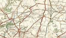
The B4057 road ran through the village.[3] Charlton had farm houses, a public house called the Carpenters Arms, a post office, large houses and a few cottages.
In the late 1940s nearly all of the place was demolished to make way for an extension of the main runway at Filton Airfield to accommodate take-offs of the Bristol Brabazon propeller-driven airliner. By virtue of compulsory purchase, government offered residents a market price for their homes and here offered rehousing in council housing in Patchway, which many took up to retain community links.
Subsequent use of the site
Filton Airfield, later Bristol Filton Airport, operated until the end of 2012. Although the Brabazon project was cancelled in 1953, the extended runway proved very useful later, when Vulcan V bombers were dispersed to Filton during the Cuban Missile Crisis and when Concorde supersonic airliners took off. The runway over the site was later used by various large Airbus jetliners, such as the A300 and A330.
After the closure of the airfield, parts of the site were sold for redevelopment. Nine acres of the site were developed to house the Aerospace Bristol museum, including a new hangar to house Concorde 216. The runway over the site of Charlton was used to bring in exhibits, and the museum opened in 2017.
A mixed use development, to be known as New Charlton, has been proposed between Patchway and Cribbs Causeway, on the site of the runway extension over the village.[4]
Survival of the name
The name survives in Charlton Common – a public recreation area, to the south of the original settlement – Charlton Road, which led from Passage Road, Westbury on Trym, to the village, and Charlton Lane, which led from Henbury and Brentry.
In the 1970s the name was resurrected for the new development of Charlton Mead, on the south side of Filton Airfield near Southmead, and in 2009 it was used again for the new development of Charlton Hayes, on the north side of Filton Airfield at Patchway.
See also
- Heathrow (hamlet), a less populous hamlet demolished similarly
References
- ↑ "Descriptive Gazetteer Entry for Charlton. Imperial Gazetteer of England and Wales (1870-72)". A Vision of Britain. University of Portsmouth. Retrieved 14 September 2017.
- ↑ "Henbury CP. Relationships and changes". A Vision of Britain. University of Portsmouth. Retrieved 24 December 2017.
- ↑ Ordnance Survey map, 1949 Archived 1 July 2016 at the Wayback Machine.
- ↑ "Cribbs/Patchway New Neighbourhood". Patchway Journal. Retrieved 24 December 2017.
External links
- Paul Townsend. "The Lost Villages of Bristol". Retrieved 2011-01-05.
- Google Earth view of Bristol Filton Airport and the site of Charlton
- Closer Google Earth view of the site of Charlton (north of "Charlton Common")