Almondsbury
| Almondsbury | |
|---|---|
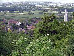 Part of Almondsbury from The Tump. The spire is Saint Mary the Virgin church. | |
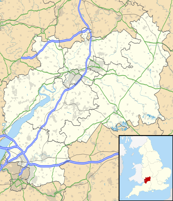 Almondsbury Almondsbury shown within Gloucestershire | |
| Population | 4,705 (2011 census)[1] |
| OS grid reference | ST604843 |
| Civil parish |
|
| Unitary authority | |
| Ceremonial county | |
| Region | |
| Country | England |
| Sovereign state | United Kingdom |
| Post town | BRISTOL |
| Postcode district | BS32 |
| Dialling code | 01454 |
| Police | Avon and Somerset |
| Fire | Avon |
| Ambulance | South Western |
| EU Parliament | South West England |
| UK Parliament | |
Almondsbury is a large village near junction 16 of the M5 motorway, in South Gloucestershire, England, and a civil parish which also includes the villages of Hortham, Gaunt's Earthcott, Over, Easter Compton, Compton Greenfield, and Hallen.
Governance
Almondsbury is in the South Gloucestershire unitary authority area. The electoral ward of Almondsbury covers the same area as the civil parish, stretching from Gaunt's Earthcott east of the M5 motorway south west to Hallen on the boundary with Bristol.
Description
The village is split by a steep hill, part of the escarpment overlooking the Severn floodplain. At the bottom of the hill is Lower Almondsbury where a pub and hotel, The Bowl Inn, is situated. South Wales, the Forest of Dean, the River Severn and both Severn Bridges are visible from the higher parts of the village.
The place-name 'Almondsbury' is first attested in the Domesday Book of 1086, where it appears as Almodesberie. The name means 'Æthelmod's or Ealhmund's burgh or fortified place'.[2]
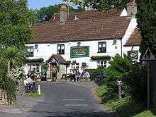
The pub takes its name from the bowl shape of the land surrounding the estuary. Parts of this whitewashed-stone inn were originally the three cottages erected in 1146 to house the monks building the adjacent church of St Mary the Virgin. The present building became a licensed inn in 1550.[3]
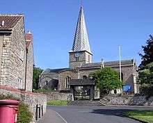
Also at the bottom of the hill is the local church, dedicated to Saint Mary the Virgin.
The church and tower were built in 1140 AD. The lead-covered spire was added some time before 1619.
In 1817, a woman purporting to be Princess Caraboo was found in the town, in what was to become one of the more elaborate deceptions of the period.[4]
Amenities
Another pub, The Swan Inn, is located on the A38, in the upper part of the village, almost opposite an open space known as Almondsbury Tump.
In March 2009 a community shop was opened in the village by the not-for-profit Almondsbury Community Services Association (ACSA), situated opposite the Old School Hall at 14 Church Road. The community shop is staffed entirely by unpaid volunteers. The aim of the project goes beyond a village shop, being a service for the village, to support local suppliers wherever possible, and to be another focal point where people in the village can meet. A proportion of the surplus generated by the shop is returned to community projects and organisations in the village. The main manager of the shop is Alun Evans.
The village also has an ambulance station, a motorway police station, a garden centre, and a restaurant/pub. A helicopter base is currently in development next to the Almondsbury Interchange as a new home for NPAS Filton and the Great Western Air Ambulance.[5]
Sport and leisure
Almondsbury is home to non-League football club Almondsbury UWE who play at Almondsbury Sports & Social Complex on Gloucester Road.[6] Almondbury Cricket Club and Almondsbury Tennis club are also based at the same site.
Gloucestershire FA are also based in Almondsbury at Oakland Park.[7] North Bristol RFC play next door.[8]
Education
Education is provided by Almondsbury Church of England Primary School. This is a state maintained school. The Ofsted report, dated April 2009, rated the school as good (outstanding in places). For secondary education Almondsbury is served by Patchway Community College.
Notable residents
Almondsbury is the birthplace of Alex Kapranos, the lead singer of Franz Ferdinand.[9]
Civil parish
The civil parish of Almondsbury is much larger than the village. It includes the villages of Hortham, Gaunt's Earthcott, Over, Easter Compton, Compton Greenfield, Catbrain and Hallen. It also includes Cribbs Causeway and the site of the village of Charlton, now the western end of Filton Airfield.
When it was originally created in 1866 the civil parish also included Patchway, but not Easter Compton, Compton Greenfield, Hallen, Cribbs Causeway or Charlton, all of which were transferred from the parish of Henbury in 1935. The parish of Patchway was separated from Almondsbury in 1953.[10]
Notes and references
- ↑ "Parish population 2011". Retrieved 18 March 2015.
- ↑ Eilert Ekwall, The Concise Oxford Dictionary of English Place-names, p.7.
- ↑ "About Us". The Bowl Inn. Retrieved 12 March 2015.
- ↑ Dictionary of National Biography. Oxford University Press. 2004.
- ↑ "Emergency service's air base plan in Almondsbury given all-clear for take-off". Gazette Series.
- ↑ "Almondsbury UWE Football Club". Toolstation League. Retrieved 17 February 2017.
- ↑ "Directions". Gloucestershire FA. Retrieved 17 February 2017.
- ↑ "About". North Bristol RFC. Retrieved 17 February 2017.
- ↑ IMDB.
- ↑ "Almondsbury Gloucestershire". Vision of Britain. University of Portsmouth. Retrieved 2 September 2017.
External links
| Wikimedia Commons has media related to Almondsbury. |