Khan el-Khalili
Khan el-Khalili (Arabic: خان الخليلي) is a major souk in the historic center of Islamic Cairo. The bazaar district is one of Cairo's main attractions for tourists and Egyptians alike.
History

The site of Khan el-Khalili was originally the site of the mausoleum known as the turbat az-za'faraan (Saffron Tomb),[1] which was the burial site of the Fatimid caliphs.[2][3]:57 The mausoleum was part of the Fatimid Great Eastern Palace complex, begun in 970 AD by Gawhar al-Siqilli, the general who conquered Egypt for the Fatimid dynasty and founded Cairo that same year.[3]:56–57
By the time of Sultan Barquq, the first Circassian (or Burji) Mamluk Sultan, in the late 14th century, Egypt had been significantly affected by the ravages of the Black Death but continued to be the center of great economic activity, with many commercial and religious buildings still being constructed at this time.[3]:147 During Barquq's first reign (1382-1389) his Master of the Stables (or amir akhur), Jaharkas al-Khalili, demolished the Fatimid cemetery to erect a large caravanserai (خان khan in Arabic; a building that could house merchants and their goods) at the heart of the city.[4]:179 He reportedly disposed of the bones of the Fatimid royal family by throwing them into the rubbish hills east of the city.[3]:57
The khan was located close to al-Azhar and to the area known as Bayn al-Qasrayn, at the middle of Cairo's most important zone of economic activity. This economic and commercial zone extended along the city's main north-south axis, the qasaba (now known as al-Mu'izz street), and was also the privileged site of many monumental religious complexes built throughout the Mamluk period and beyond.[3] Later sultans also built commercial establishments in the vicinity, such as the wikala (another word meaning caravanserai) of Sultan Qaytbay and the wikala of Sultan al-Ghuri. By the late 15th century, the district around Khan el-Khalili had also become the major center of foreign trade, including the sale of slaves and precious stones.[5]:62

In the early 16th century, Sultan al-Ghuri, Egypt's last powerful Mamluk sultan (1501-1516), modified the layout of the whole district through a major campaign of demolition and new construction. In addition to building his own religious and funerary complex and a large wikala (the same mentioned above), he demolished the original khan built by al-Khalili and rebuilt it in 1511 as a commercial complex with monumental gates and streets in a regular grid plan.[3]:179 This sort of complex resembled what in other cities was often known as a qaysariyya (also bedestan in Turkish), a central bazaar where the most precious goods were sold, which often had roofed streets and was protected by locked gates at night. It's possible that this was done in imitation of similar commercial complexes in major Ottoman cities, at a time when the Ottoman Empire was the major rival of the Egyptian Mamluk state and when Turkish merchants were probably increasingly prominent in Cairo.[3]:179
Among al-Ghuri's constructions was the Wikala al-Qutn ("of cotton"). Parts of this structure are still visible today, including an ornate gate and the upper stories whose facade is lined with iron-grilled windows where merchants' rooms were located. Two other monumental gates, the Bab al-Badistan and the Bab al-Ghuri, also date from this time and are still standing today.[4]:179
From al-Ghuri's reign onwards, the district became associated with Turkish merchants, and during the Ottoman period the Turkish community of Cairo was centred here.[3]
Today
The Khan el-Khalili today is mainly occupied by Egyptian rather than foreign merchants and shopholders, but is significantly geared towards tourists. Shops typically sell souvenirs, antiques and jewellery, but many traditional workshops continue to operate in the surrounding area and the adjoining goldsmiths' souq, for example, is still important for locals.[4]:180[6]:81
In addition to shops, there are several coffeehouses (مقهى maqha ), restaurants, and street food vendors distributed throughout the market. The coffeeshops are generally small and quite traditional, serving Arabic coffee and usually offering shisha. One of the oldest and most famous coffeehouses is Fishawi's, established in 1773.[6]:109
The al-Hussein Mosque is adjacent to Khan el-Khalili, and Al-Azhar University and its mosque are nearby.
In literature
Naguib Mahfouz's novel Midaq Alley (1947) is set in an alley in Khan el-Khalili.
Pivotal events of Neil Stephenson's novel The Confusion (2004), which is the second book of his The Baroque Cycle series, are set in the caravanserai within Khan el-Khalili.
Terrorist attacks
The market was a target of terrorism during the spate of attacks in Cairo in April 2005. The suicide attack in the market, on April 7, killed 21 people (eleven Egyptians, two French tourists, one American, and seven foreigners of unidentified origin). It was the first attack in the series; this attack drove away tourists from Egypt in general and Khan el-Khalili in particular for some time.
The market was again a target of terrorism on 22 February 2009. In this attack a 17-year-old French girl was killed and 22 people were injured.
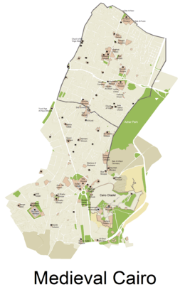
Gallery
 Medieval gateways in Khan el-Khalili
 Souq street in Khan el-Khalili.
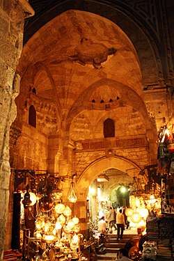
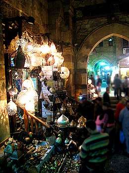
- Lantern shop under Bab el-Ghuri.
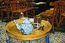 Tea at Fishawi's Café.
.jpg) Souq street in Khan el-Khalili.
Souq street in Khan el-Khalili._-_Egypt-13A-097.jpg) Souq street.
Souq street.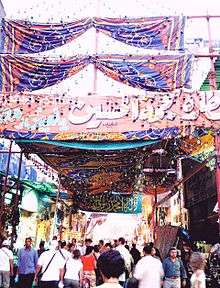 Souq street.
 Souq street.
_-_Egypt-13A-093.jpg) Shops in the souq.
Shops in the souq._-_Egypt-13A-094.jpg) Souq street.
Souq street._-_Egypt-13A-096.jpg) Spices for sale.
Spices for sale. Hookah pipes on sale.
_-_Egypt-13A-100.jpg) El-Hussein Square, on the edge of Khan el-Khalili.
El-Hussein Square, on the edge of Khan el-Khalili. Building on el-Hussein Square, on the edge of Khan el-Khalili.
_-_Egypt-13A-088.jpg) An old building west of el-Hussein Mosque.
An old building west of el-Hussein Mosque._-_Egypt-13A-103.jpg) Window detail of more modern building, part of Al-Azhar university.
Window detail of more modern building, part of Al-Azhar university._-_Egypt-13A-105.jpg) Details of more modern building, part of Al-Azhar university.
Details of more modern building, part of Al-Azhar university. Souq street at night.
 Souq street at night.
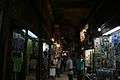 Souq street at night.
 Souq street at night.
 Souvenirs.
 Souvenirs.
 Mosque and Sabil-Kuttab of Shaykh Ali al-Mutahhar, near Khan el-Khalili.
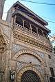 Mosque and Sabil-Kuttab of Shaykh Ali al-Mutahhar, near Khan el-Khalili.
 Portal of the Mosque-Madrasa of al-Ashraf Barsbay, in Khan el-Khalili district.
References
| Wikimedia Commons has media related to Khan el-Khalili. |
- ↑ Lev, Y. 2001. "Aspects of the Egyptian Society in the Fatimid Period". In Vermeulen, Urbain & J. van Steenbergen (eds.). Egypt and Syria in the Fatimid, Ayyubid, and Mamluk Eras III: Proceedings of the 6th, 7th and 8th International Colloquium Organized at the Katholieke Universiteit Leuven in May 1997, 1998, and 1999. Peeters Publishers. p. 20.
- ↑ Discover Islamic Art
- 1 2 3 4 5 6 7 8 Raymond, André. 1993. Le Caire. Fayard.
- 1 2 3 Williams, Caroline. 2008 (6th ed.). Islamic Monuments in Cairo: The Practical Guide. Cairo: American University in Cairo Press.
- ↑ Behrens-Abouseif, Doris. 2007. Cairo of the Mamluks: A History of Architecture and its Culture. Cairo: The American University in Cairo Press.
- 1 2 O'Neill, Zora et al. 2012. Lonely Planet: Egypt (11th edition).
Coordinates: 30°02′51″N 31°15′44″E / 30.04750°N 31.26222°E