Kentucky Route 15
| ||||
|---|---|---|---|---|
| Route information | ||||
| Maintained by KYTC | ||||
| Length | 131.418 mi[1] (211.497 km) | |||
| Major junctions | ||||
| South end |
| |||
|
| ||||
| North end |
| |||
| Location | ||||
| Counties | Letcher, Knott, Perry, Breathitt, Wolfe, Powell, Clark | |||
| Highway system | ||||
| ||||

Kentucky Route 15 begins at a junction of US 119/Corridor F & Business KY 15 in Whitesburg, and terminates in Winchester at US 60. It is a major route, connecting the coalfields of the Cumberland Plateau with Lexington and other cities in the Bluegrass region. The segment from Whitesburg to KY 15 at Campton, which in turn connects to the Bert T. Combs Mountain Parkway near the town, is also the primary part of Corridor I of the Appalachian Development Highway System.
Future
Currently, KY 15 is being relocated onto a new four-lane divided alignment in phases. Construction on section 17 of the relocation project is from KY 205 at Vancleve to Fivemile; construction began on January 6, 2005 at a cost of $36.4 million and is 100% complete.[2] Work is also progressing on section 16 from Fivemile to Wolverine; construction began on November 2, 2006 with a projected cost of $4.7 million and is approximately 95% complete. There are additional plans to reconstruct the segment from Jackson south to Hazard on new alignment beginning in 2008.
The current construction is progressing from Vancleve to Jackson. Local reports suggest that the roadway will be opening for traffic flow by the summer of 2013. Construction of the section between Jackson and Haddix, KY has not started. The current budget crisis and lowered revenues for state and federal construction projects may delay groundbreaking on that section for years. (Updated June 2013)
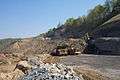 Working on a cut near Vancleve.
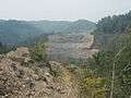 Looking north across Frozen Creek and KY 1812.
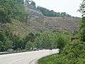 Looking south on KY 15 near the northern end of construction on section 17 at KY 205.
Major intersections
| County | Location | mi | km | Destinations | Notes |
|---|---|---|---|---|---|
| Letcher | Whitesburg | 0.000 | 0.000 | Southern terminus of business route | |
| 1.389 | 2.235 | Western terminus of connector road | |||
| 2.284 | 3.676 | Northern terminus of business route; south end of KY 931 overlap | |||
| | 2.736 | 4.403 | North end of KY 931 overlap | ||
| | 3.918 | 6.305 | Northern terminus of KY 3401 | ||
| | 4.794 | 7.715 | Southern terminus of KY 3402 | ||
| Van | 6.225 | 10.018 | Southern terminus of KY 1811; south end of KY 160 overlap | ||
| | 8.911 | 14.341 | Western terminus of KY 1148 | ||
| Isom | 9.216 | 14.832 | South end of KY 7 concurrency | ||
| | 9.876 | 15.894 | North end of KY 7 concurrency | ||
| Knott | | 15.262 | 24.562 | North end of KY 160 overlap | |
| | 16.945 | 27.270 | Southern terminus of KY 1231 | ||
| | 17.375 | 27.962 | Carr Creek State Park | ||
| | 20.435 | 32.887 | Eastern terminus of KY 1088 | ||
| Perry | Vicco | 21.253 | 34.203 | Northern terminus of KY 1095 | |
| | 26.846 | 43.204 | Northern terminus of KY 7 | ||
| Glomawr | 29.581 | 47.606 | Southern terminus of KY 451 | ||
| | 29.970 | 48.232 | |||
| Hazard | 31.795 | 51.169 | Southern terminus of Hazard business route | ||
| 32.515 | 52.328 | Northern terminus of connector road | |||
| 33.933 | 54.610 | Northern terminus of Hazard business route | |||
| 34.351 | 55.283 | Interchange; western terminus of KY 550; south end of KY 80 overlap | |||
| 35.861 | 57.713 | Interchange; north end of KY 80 overlap; ramp from EB Hal Rogers Parkway to KY 15 south of intersection | |||
| 36.023 | 57.973 | Interchange; eastern terminus of Hal Rogers Parkway; parkway exit 59; ramp from WB KY 80 to KY 15 just east of here | |||
| Bonnyman | 36.608 | 58.915 | |||
| | 40.518 | 65.207 | Southern terminus of KY 1067 | ||
| | 41.399 | 66.625 | Eastern terminus of KY 28 | ||
| Breathitt | Ned | 46.372 | 74.628 | Northern terminus of KY 2446 | |
| | 49.890 | 80.290 | Northern terminus of KY 1278 | ||
| Lost Creek | 53.582 | 86.232 | Northern terminus of KY 476 | ||
| Haddix | 55.019 | 88.544 | Northern terminus of KY 1110 | ||
| Jackson | 60.487 | 97.344 | Eastern terminus of KY 1098; southern terminus of KY 1812 | ||
| 60.741 | 97.753 | South end of KY 30 overlap | |||
| 62.593 | 100.734 | South end of KY 1812 overlap; eastern terminus of KY 3068 | |||
| 62.813 | 101.088 | ||||
| 63.289 | 101.854 | North end of KY 1812 overlap | |||
| 63.740 | 102.580 | North end of KY 30 overlap | |||
| | 65.699 | 105.732 | South end of KY 205 overlap | ||
| | 66.802 | 107.507 | North end of KY 205 overlap | ||
| | 68.164 | 109.699 | South end of KY 1812 overlap | ||
| Vancleve | 69.164 | 111.309 | Interchange; 205 both ways, 1812 to the north; north end of KY 1812 overlap | ||
| Wolfe | Bethany | 73.200 | 117.804 | South end of KY 1261 overlap | |
| 73.239 | 117.867 | North end of KY 1261 overlap | |||
| | 77.059 | 124.014 | Northern terminus of KY 2028 | ||
| | 80.199 | 129.068 | Southern terminus of connector road | ||
| | 80.377 | 129.354 | |||
| Campton | 81.022 | 130.392 | Southern terminus of KY 15 Spur; western terminus of KY 191 | ||
| | 82.239 | 132.351 | Northern terminus of KY 651 | ||
| | 84.897 | 136.628 | Western terminus of KY 1653 | ||
| | 85.129– 85.422 | 137.002– 137.473 | Interchange; Mountain Parkway exit 40 | ||
| | 84.455 | 135.917 | Western terminus of KY 3040 | ||
| | 85.555 | 137.687 | South end of KY 715 overlap | ||
| Pine Ridge | 86.389 | 139.030 | North end of KY 715 overlap | ||
| Powell | Slade | 93.704 | 150.802 | South end of KY 11 concurrency | |
| | 95.200 | 153.210 | Northern terminus of KY 77 | ||
| | 97.652 | 157.156 | Northern terminus of KY 1639 | ||
| Bowen | 99.517 | 160.157 | Western terminus of KY 613 | ||
| | 102.535 | 165.014 | Northern terminus of KY 3354 | ||
| Rosslyn | 103.015 | 165.787 | Southern terminus of KY 1184 | ||
| Stanton | 105.744 | 170.178 | |||
| 105.791 | 170.254 | Southern terminus of KY 2486 | |||
| 106.325 | 171.114 | Southern terminus of KY 2073 | |||
| Clay City | 109.298 | 175.898 | Southern terminus of KY 2480 | ||
| 109.741 | 176.611 | Western terminus of KY 1057 | |||
| 109.978 | 176.992 | Western terminus of KY 2026; northern terminus of KY 2481 | |||
| 110.513 | 177.853 | Southern terminus of KY 2479 | |||
| 110.949 | 178.555 | North end of KY 11 concurrency | |||
| 111.466 | 179.387 | Southern terminus of KY 3022 | |||
| 111.478– 111.511 | 179.406– 179.460 | Interchange; Mountain Parkway exit 16 | |||
| 111.613 | 179.624 | Eastern terminus of KY 82; ramp to parkway to the south, 82 to the west; 15 turns north | |||
| | 112.904 | 181.701 | Northern terminus of KY 3352 | ||
| Clark | Goffs Corner | 117.692 | 189.407 | ||
| Pilot View | 122.295 | 196.815 | Southern terminus of KY 3368 | ||
| | 128.086 | 206.134 | |||
| | 128.718 | 207.152 | Western terminus of KY 1960 | ||
| Winchester | 129.449 | 208.328 | |||
1.000 mi = 1.609 km; 1.000 km = 0.621 mi
| |||||
Special routes
Kentucky Route 15X
| |
|---|---|
| Location | Whitesburg, Letcher County |
| Length | 2.838 mi[1] (4.567 km) |
Kentucky Route 15 Business in Whitesburg, in Letcher County, signed as KY 15X, is the business route of KY 15 in Whitesburg. It begins at KY 15's southern terminus and ends at KY 15 north of town. The route is 2.838 miles (4.567 km) long.
Kentucky Route 15 Connector
| |
|---|---|
| Location | Whitesburg, Letcher County |
| Length | 0.24 mi[1] (0.39 km) |
Kentucky Route 15 Connector (KY 15C) provides access from KY 15 to KY 15X and the Letcher County Veterans Memorial Museum in Whitesburg. It is 0.24 miles (0.39 km) long.
Kentucky Route 15 Business (Hazard)
| |
|---|---|
| Location | Hazard, Perry County |
| Length | 2.306 mi[1] (3.711 km) |
Kentucky Route 15 Business (KY 15 BUS) is a business route of KY 15 in Hazard, Perry County. It is the original alignment of KY 15 through the city. It is 2.306 miles (3.711 km) long.
Kentucky Route 15 Spur
| |
|---|---|
| Location | Campton, Wolfe County |
| Length | 1.058 mi[1] (1.703 km) |
Kentucky Route 15 Spur (KY 15 Spur) is the spur route connecting KY 15 with the Bert T. Combs Mountain Parkway's Exit 46 interchange at Campton, in Wolfe County. The length of this alignment is 1.058 miles (1.703 km) long. This roadway is not accessible from the Mountain Parkway's westbound lanes.
References
- 1 2 3 4 5 "Kentucky Transportation Cabinet - Division of Planning - Highway Information System Official Milepoint Route Log Extract". Archived from the original on April 30, 2007. Retrieved 2007-06-11.
- ↑ KY-15 Corridor. Kentucky Transportation Cabinet. Archived from the original on March 3, 2007. Retrieved 2007-05-17.